Perhentian Islands, Malaysia tide times
Perhentian Islands, Malaysia tide forecast — heights relative to MSL.
Today's tide times for Perhentian Islands, Malaysia
Tide times at Perhentian Islands, Malaysia on Saturday, 4 July 2026: first low tide at 08:00am, first high tide at 11:12am. Sunrise 06:59am, sunset 07:27pm.
Tide chart for Perhentian Islands, Malaysia
24-hour cosine-interpolated curve around the present moment. Heights relative to MSL. Predictions: Predictions: Open-Meteo Marine (MeteoFrance SMOC, 0.08° grid).
Sun, moon and conditions on Sat 04 Jul
Snapshot at build time — refreshes daily. Sea state from Open-Meteo Marine.
Highs and lows next 7 days
Every predicted high and low for the next week, with the daily tidal coefficient (0–120; higher = bigger swing, > 95 means stronger currents).
Other spots nearby
The three closest curated TideTurtle locations to Perhentian Islands, Malaysia, measured by great-circle distance.
Today's solunar windows
Solunar tradition: major periods are the ≈3h windows around moon transit and opposition; minor are ≈2h around moonrise and moonset. Pair with the local tide stage and wind for the best read.
Cycle dates near Perhentian Islands, Malaysia
Last spring tide on Sat 04 Jul (range 1.4m). Next spring tide on Fri 10 Jul (range 1.3m). Next neap on Wed 08 Jul.
Spring tides cluster around new and full moons (biggest swings). Neap tides land on quarter moons (smallest swings). See the spring tide and neap tide glossary entries for the why.
About tides at Perhentian Islands, Malaysia
A short guide to the coastline at Perhentian Islands, Malaysia — geography, sea state, and what the tide is actually doing under your feet.
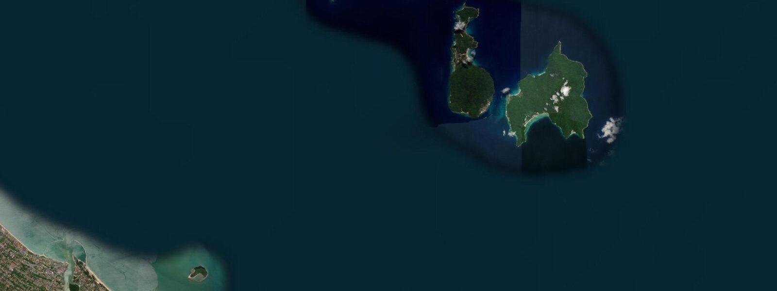
The Perhentian Islands — Pulau Perhentian Besar and Pulau Perhentian Kecil — sit 21 km off the Terengganu coast in the South China Sea. They are two islands separated by a 1.5 km channel, and between them they contain the most established budget dive and snorkel destination on Malaysia's east coast. Coral is visible from the surface in the bays on both islands; green and hawksbill sea turtles are resident on the reef and surface regularly in the bays within swimming distance of the accommodation.
Besar — Big Island — hosts the larger resort infrastructure, the marine park office, and the dive centres serving the main reef sites on the western coast. Kecil — Small Island — holds Long Beach on its exposed eastern coast (a 400 m arc of sand with a dense strip of budget chalets, dive operators, and the backpacker social scene that has defined the Perhentians for two decades) and the quieter Coral Bay on the western side, shallower and more sheltered, where the snorkelling off the beach hits turtle territory reliably. The channel between the two islands is the productive zone for the stronger current dive sites: the Sugar Wreck, a small coastal trader at 20 m, and the channel pinnacles that concentrate reef fish in the tidal flow.
The South China Sea here is mixed semidiurnal with a spring range of 1.2 to 1.8 m. The tidal state matters most for beach access: at the spring high, Long Beach narrows considerably and the zone between the beach bars and the water is compressed; at the spring low, the sand expands by 20 to 30 m and the shallow reef flat is accessible for wading and surface snorkelling without fins. The channel between the two islands runs 0.5 to 1.5 knots depending on tidal phase; dive operators plan the channel sites on the running current for the best fish aggregations.
The monsoon closure is absolute. From November through February, the northeast monsoon builds seas of 3 to 4 m in the open South China Sea and the speedboat services from Kuala Besut suspend. The islands are effectively inaccessible to visitors for four months. Arriving in March at the season opening is arriving to a freshly reopened island — sand redistributed by the monsoon swell, dive sites cleared of algae buildup, sometimes new infrastructure. The fresh-season phenomenon is real and the diving in early March is often some of the best of the year in terms of visibility.
The primary marine park species are hawksbill and green turtles, blacktip and whitetip reef sharks on the outer reef slope, bumphead parrotfish on the morning reef flat, and the giant clams in the seagrass meadows at the southern end of Besar. Sea turtle encounters in the bays are governed by marine park rules — no touching, no flash photography within 3 m, no blocking the turtle's path to surface. These rules are enforced by the park wardens and the dive operators; noncompliance results in immediate removal from the water. Predictions on this page come from Open-Meteo Marine (gridded model, ±45 min / ±0.2–0.3 m). The water sports scene on both islands — windsurfers, kayakers, snorkellers, and the occasional kitesurfer on the northern beaches of Besar — is entirely dependent on the monsoon window. Outside the November–February closure, the islands offer consistent light winds from the northeast that produce good windsurfing and kite conditions in the morning, settling to flat water in the afternoon. The Long Beach evening scene on Kecil — restaurants and beach bars along the 400 m sand arc — is the social gravitational centre of the Perhentian experience; the conversation is as likely to be about dive site conditions as it is about travel.
Tide questions about Perhentian Islands, Malaysia
Quick answers to the most common questions about tide times, range, and water access at Perhentian Islands, Malaysia.
When is the next high tide at the Perhentian Islands?
The hero block shows the next predicted high at the Perhentians in Malaysia Standard Time (MYT, UTC+8). Mixed semidiurnal pattern, spring range 1.2 to 1.8 m. At the spring high, beach widths at Long Beach and Coral Bay narrow; at the spring low, sand flats expand by 20 to 30 m and the shallow reef zone is easier to access without fins. The 7-day table covers all four daily tidal extremes. Predictions from Open-Meteo Marine (gridded model, ±45 min / ±0.2–0.3 m).
What is the tidal range at the Perhentians?
Spring range runs 1.2 to 1.8 m; neap range about 0.7 to 1.0 m. The mixed semidiurnal pattern produces two unequal highs and two unequal lows each day — the larger swing on a spring day is in the 1.5 to 1.8 m band, enough to change beach width noticeably and to run meaningful current through the inter-island channel. The biggest spring swings occur around new and full moons. The 1.2 to 1.8 m spring range in the South China Sea here is larger than the Society Islands or Maldives but smaller than the Andaman Sea; it is enough to noticeably change beach width and shallow reef access across the cycle.
Where do these predictions come from?
Open-Meteo Marine, a free gridded global ocean model, accuracy ±45 min / ±0.2–0.3 m. Jabatan Laut Malaysia (Marine Department of Malaysia) publishes authoritative harmonic predictions for Malaysian waters; the nearest reference station for the South China Sea off Terengganu is Kuala Terengganu. The Perhentians have a small offset from that station; local dive operators apply the correction for channel dive timing. Jabatan Laut Malaysia's tide tables include the Perhentians reference station; the tables are published annually and available at Malaysian maritime offices and online through the JLM website.
When is the Perhentians open, and how do I get there?
The islands are open March through October; all speedboat services from Kuala Besut jetty (45 minutes south of Kota Bharu, 4 hours north of Kuala Terengganu) suspend entirely from November through February for the northeast monsoon. Speedboats run on demand from Kuala Besut; the crossing takes 30 to 45 minutes and is roughest in the afternoon sea breeze. In peak season (June–August), book accommodation before arriving at the jetty — chalets on both islands sell out. Arrive at Kuala Besut by 10:00 for the most crossings available on the day.
Is this safe to use for navigation?
No. TideTurtle is a planning tool. The South China Sea approaches to the Perhentians and the inter-island channel have submerged reefs and shoals not visible at surface level. For vessel navigation in these waters, use official Malaysia Marine Department chart products. The speedboat operators running from Kuala Besut are licensed and know the reef positions; private boats approaching the islands in poor visibility without local knowledge face grounding risk. The South China Sea approaches to the Perhentians have coral reefs and the inter-island channel has submerged shoals; Malaysia Marine Department chart products cover these waters for vessel operations.
8-day tide table — Perhentian Islands, Malaysia
Heights relative to MSL. Predictions: Open-Meteo Marine (MeteoFrance SMOC, 0.08° grid) — heights relative to MSL (not chart datum / LAT). Model-derived.
| Day | Type | Time | Height |
|---|---|---|---|
| Sat 04 Jul | Low | 08:00 | 1.0m |
| High | 11:12 | 1.5m | |
| Sun 05 Jul | Low | 02:47 | 0.1m |
| Mon 06 Jul | High | 11:56 | 1.3m |
| Low | 20:50 | 0.4m | |
| Tue 07 Jul | Low | 03:50 | 0.4m |
| High | 12:15 | 1.2m | |
| Low | 20:10 | 0.3m | |
| Wed 08 Jul | High | 12:22 | 1.1m |
| Low | 20:12 | 0.2m | |
| Thu 09 Jul | High | 12:10 | 0.9m |
| Fri 10 Jul | Low | 21:07 | -0.1m |
| Sat 11 Jul | High | 06:15 | 1.3m |