Palermo tide times
Palermo tide forecast — heights relative to MSL.
Today's tide times for Palermo
Tide times at Palermo on Friday, 31 July 2026: first high tide at 02:00, first low tide at 04:50, second high tide at 23:00. Sunrise 06:07, sunset 20:18.
Tide chart for Palermo
24-hour cosine-interpolated curve around the present moment. Heights relative to MSL. Predictions: Predictions: Open-Meteo Marine (MeteoFrance SMOC, 0.08° grid).
Sun, moon and conditions on Fri 31 Jul
Snapshot at build time — refreshes daily. Sea state from Open-Meteo Marine.
Highs and lows next 7 days
Every predicted high and low for the next week, with the daily tidal coefficient (0–120; higher = bigger swing, > 95 means stronger currents).
Other spots nearby
The three closest curated TideTurtle locations to Palermo, measured by great-circle distance.
Today's solunar windows
Solunar tradition: major periods are the ≈3h windows around moon transit and opposition; minor are ≈2h around moonrise and moonset. Pair with the local tide stage and wind for the best read.
Cycle dates near Palermo
Next spring tide on Sun 02 Aug (range 0.3m). Next neap on Wed 05 Aug.
Spring tides cluster around new and full moons (biggest swings). Neap tides land on quarter moons (smallest swings). See the spring tide and neap tide glossary entries for the why.
About tides at Palermo
A short guide to the coastline at Palermo — geography, sea state, and what the tide is actually doing under your feet.
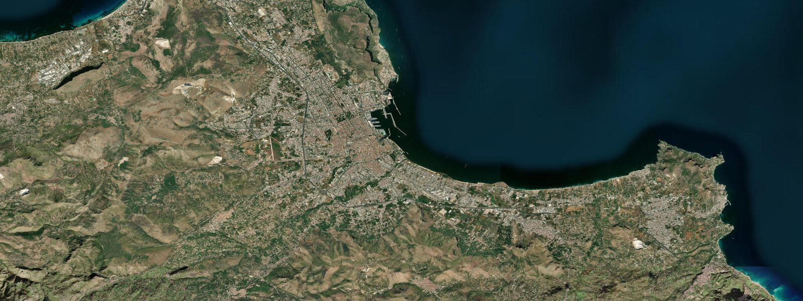
Palermo sits on the northwest coast of Sicily, the largest island in the Mediterranean, backed by the Conca d'Oro — the golden shell-shaped valley — and fronted by the Tyrrhenian Sea. The city is built around its harbour, one of the oldest in the western Mediterranean, and the Arab-Norman architecture downtown (cathedral, Palatine Chapel, La Martorana, the palaces at Zisa and Cuba) records the layered occupation that defined Sicily from 827 to 1072 under Aghlabid and Kalbid rule and from 1072 under the Normans. 1 metres.
Like Genoa and most other Italian Mediterranean ports, the astronomical tide here is a minor variable and weather-driven water level changes are the practical reality. What makes Sicily's relationship with tides distinctive is not the Tyrrhenian coast where Palermo sits, but the Strait of Messina on the eastern tip of the island — a geographically separate phenomenon that belongs to the same regional picture. The Strait of Messina is a 3-kilometre-wide channel between Sicily and the Calabrian toe of mainland Italy, with a shallow sill in the middle.
The Tyrrhenian and Ionian Seas sit either side of the strait, and their tidal signals arrive slightly out of phase with each other. Despite the tiny astronomical range visible at any measurement point along the strait, the phase difference between the two basins creates a hydraulic gradient that drives tidal currents through the strait. Those currents can reach 3 to 4 knots at peak spring flow — among the fastest tidal currents in the Mediterranean — and the interaction of the fast flow with the irregular submarine topography of the sill generates upwelling eddies, surface whirlpools, and rip lines.
This is the original physical basis for the Scylla and Charybdis mythology in Homer's Odyssey: the eddies and boils around the sill at Capo Peloro (the Sicilian side) are real, predictable, and tide-state dependent. They are most pronounced around maximum flood and ebb, most subdued at the slack periods around high and low tide. For vessels transiting north-south through the Strait of Messina — and virtually all north-south traffic along the Italian west coast passes through the strait — the tidal current state is the primary navigation variable.
The Villa San Giovanni to Messina ferry crossing (the busiest short sea crossing in Italy, carrying both passengers and rail wagons connecting the mainland rail network to Sicily) operates on a timetable that accounts for the current. On the Tyrrhenian coast at Palermo, the microtidal environment means practical coastal planning focuses on other variables. Mondello beach, 11 kilometres northwest of the city centre in a sheltered bay between Monte Pellegrino and Capo Gallo, is the main city beach — a wide sand strand inside a protected bay formed by the two headlands.
The bay geometry shelters the beach from the prevailing swell directions and the water inside is generally calm. 3 metre tidal signal at Mondello is below the threshold that changes the usable beach width perceptibly for most visitors. 4 metres above the astronomical prediction and bring warm, dusty air from the Sahara.
The Palermo port handles Sicily-mainland ferry services (primarily to Civitavecchia, Naples, and Livorno), and the busy passenger terminal is a significant element of Sicily's transport geography. Ferry scheduling here is sea-state and season dependent, not tide dependent. Beyond Mondello, the coastline around the Capo Gallo marine reserve to the north and the Golfo di Carini to the west holds dive sites and rocky shore fishing ground that operate on sea-state availability.
The diving inside the Capo Gallo reserve — a protected marine area covering the submerged rocky slopes of the headland — is scheduled on weather windows and visibility, not tide state. The predictions on this page come from Open-Meteo Marine, a gridded global ocean model. 3 metres on height — model-derived, not from the Palermo gauge.
3 metre range, the model height uncertainty is comparable to the tidal range itself. The tidal timing information is still useful as a reference, but actual water level is dominated by atmospheric pressure and wind. ISPRA operates the Palermo gauge as part of the Italian national sea-level network.
Tide questions about Palermo
Quick answers to the most common questions about tide times, range, and water access at Palermo.
What is the tide range at Palermo?
Mean tidal range at Palermo is approximately 0.1 to 0.3 metres — among the smallest tidal signals at any major European city. Spring tides occasionally reach 0.3 metres; neap tides can drop to 0.05 metres. This is normal Mediterranean microtidal character: the Tyrrhenian Sea is a partially enclosed basin where the Atlantic tidal signal entering through the Strait of Gibraltar 2,000 kilometres to the west has been strongly attenuated by the basin geometry. ISPRA operates the Palermo sea-level gauge as part of the Italian national network.
What are the tidal currents in the Strait of Messina and are they dangerous?
The Strait of Messina has some of the fastest tidal currents in the Mediterranean — up to 3 to 4 knots at peak spring tide — driven by the slight phase difference between the Tyrrhenian and Ionian tidal signals either side of the strait. This is the physical basis for the Scylla and Charybdis mythology in Homer's Odyssey: the upwelling eddies and surface whirlpools around the shallow sill are real and tide-state dependent. For small boat operators, the currents are significant and the crossing should be timed for slack water. The Villa San Giovanni to Messina ferry route is managed professionally and accounts for the current. The currents are strongest at mid-tide (flood and ebb) and weakest at the slack periods around high and low tide.
How does the tide affect Mondello beach near Palermo?
At 0.1 to 0.3 metres, the astronomical tide at Mondello barely changes the visible beach width or water level. What matters at Mondello is sea state: the bay is sheltered from prevailing swell directions by Monte Pellegrino and Capo Gallo, but the summer tramontana (afternoon northwesterly wind) generates chop inside the bay regardless of tide state. Sirocco events from the south can raise water level by 0.2 to 0.4 metres — more than the entire tidal range — and bring turbid water in from offshore. Planning a beach day at Mondello means checking wind and swell, not the tide table.
Does the tide affect Palermo's ferry services to the mainland?
No. The ferry services operating from Palermo's passenger terminal (to Civitavecchia, Naples, Livorno, and other mainland ports) are scheduled by season, sea state, and operator timetable — not tidal state. The Tyrrhenian Sea's 0.1 to 0.3 metre tidal range is far too small to affect the navigation of large ferry vessels or the usability of the ferry berths. Ferry cancellations and delays at Palermo are driven by Mediterranean storm events and strong Sirocco or Tramontane conditions, not by tidal cycles.
Where do these tide predictions come from, and how accurate are they?
Open-Meteo Marine, a free gridded global ocean model. Accuracy is typically within plus or minus 45 minutes on timing and 0.2 to 0.3 metres on height — model-derived, not a local gauge. At Palermo, the model's height uncertainty (0.2 to 0.3 metres) is comparable to or larger than the entire tidal range (0.1 to 0.3 metres). The timing information has value as a reference for the astronomical phase, but actual water level at Palermo on any given day is driven as much by atmospheric pressure and wind setup as by the tide itself. ISPRA maintains the authoritative Italian sea-level record for Palermo.
8-day tide table — Palermo
Heights relative to MSL. Predictions: Open-Meteo Marine (MeteoFrance SMOC, 0.08° grid) — heights relative to MSL (not chart datum / LAT). Model-derived.
| Day | Type | Time | Height |
|---|---|---|---|
| Fri 31 Jul | High | 02:00 | -0.5m |
| Low | 04:50 | -0.6m | |
| High | 23:00 | -0.3m | |
| Sat 01 Aug | Low | 05:10 | -0.5m |
| High | 10:50 | -0.3m | |
| Low | 16:50 | -0.6m | |
| Sun 02 Aug | High | 11:45 | -0.3m |
| Low | 17:42 | -0.6m | |
| Mon 03 Aug | High | 00:15 | -0.2m |
| Low | 18:15 | -0.5m | |
| Tue 04 Aug | High | 00:45 | -0.3m |
| Low | 07:10 | -0.6m | |
| High | 13:10 | -0.3m | |
| Low | 19:00 | -0.5m | |
| Wed 05 Aug | High | 01:15 | -0.3m |
| Low | 07:50 | -0.6m | |
| High | 14:10 | -0.4m | |
| Low | 19:50 | -0.5m | |
| Thu 06 Aug | High | 02:10 | -0.3m |
| Low | 08:50 | -0.5m | |
| Fri 07 Aug | High | 01:00 | -0.4m |