Cagliari, Sardinia tide times
Cagliari, Sardinia tide forecast — heights relative to MSL.
Today's tide times for Cagliari, Sardinia
Tide times at Cagliari, Sardinia on Sunday, 26 July 2026: first low tide at 13:10, first high tide at 20:00. Sunrise 06:17, sunset 20:42.
Tide chart for Cagliari, Sardinia
24-hour cosine-interpolated curve around the present moment. Heights relative to MSL. Predictions: Predictions: Open-Meteo Marine (MeteoFrance SMOC, 0.08° grid).
Sun, moon and conditions on Sun 26 Jul
Snapshot at build time — refreshes daily. Sea state from Open-Meteo Marine.
Highs and lows next 7 days
Every predicted high and low for the next week, with the daily tidal coefficient (0–120; higher = bigger swing, > 95 means stronger currents).
Other spots nearby
The three closest curated TideTurtle locations to Cagliari, Sardinia, measured by great-circle distance.

Today's solunar windows
Solunar tradition: major periods are the ≈3h windows around moon transit and opposition; minor are ≈2h around moonrise and moonset. Pair with the local tide stage and wind for the best read.
About tides at Cagliari, Sardinia
A short guide to the coastline at Cagliari, Sardinia — geography, sea state, and what the tide is actually doing under your feet.
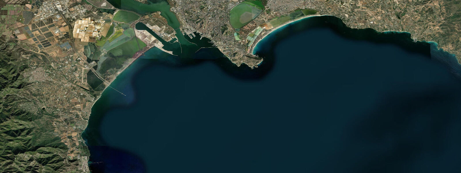
Cagliari sits on the southern shore of Sardinia at the head of the Golfo di Cagliari, the working capital of the second-largest Mediterranean island and the historical Phoenician-then-Roman-then-Pisan-then-Aragonese port that anchored the western Mediterranean trade routes for nearly three thousand years. The city wraps the Castello quarter on a limestone bluff above the modern port, with the long Poetto beach corridor running east toward the Devil's Saddle (Sella del Diavolo) headland and the Stagno di Cagliari salt-marsh and lagoon system stretching north-east of the city across the coastal plain. 3 metres and neaps dropping near flat.
The astronomical signal is genuinely tiny because the Mediterranean connects to the Atlantic only through the narrow Strait of Gibraltar. What matters more on a day-to-day basis is meteorological tide. The mistral funnels down from the Gulf of Lion across the Sardinian Sea in cold-front events, dropping water level on the western coast and raising it on the eastern by 20 to 30 centimetres on sustained event days; the scirocco southerly that builds ahead of approaching depressions does the opposite and can raise water at Cagliari by 20 to 40 centimetres on sustained events.
The defining ecological feature of the southern coast is the Stagno di Cagliari salt-marsh and lagoon system. The Molentargius-Saline regional park immediately east of the city wraps a chain of brackish lagoons, salt pans (saline), and reedbeds that hosts one of the largest greater flamingo breeding colonies in the western Mediterranean — about 10,000 to 20,000 pairs nest each spring, and the pink flocks visible from the Poetto beach promenade are a Cagliari signature. The salt-pan industry that gave the lagoons their working name was active from Roman times until the 1985 closure, and the modern lagoon system runs as a freshwater-fed brackish wetland with controlled exchange to the sea through engineered sluices.
The Marina Piccola anchorage at the Devil's Saddle headland, the working ferry terminal at Molo Sant'Agostino with daily sailings to Civitavecchia, Genoa, and Palermo, the cruise calls at the modern Porto Canale, the surf at Chia and Capo Spartivento on the south-western coast, and the rocky shore at Cala Mosca and Calamosca all read the wider weather pattern more than the tide table. ISPRA Mareografico Nazionale runs the authoritative Italian gauge network; Open-Meteo Marine drives the gridded predictions on this page.
Tide questions about Cagliari, Sardinia
Quick answers to the most common questions about tide times, range, and water access at Cagliari, Sardinia.
When is the next high tide at Cagliari?
The hero block shows the next high tide at the Cagliari harbour gauge in local Italian time (CET/CEST with DST). The 7-day table covers all daily highs and lows. The Mediterranean micro-tide pattern produces two small highs and two small lows of comparable size each day, but the astronomical signal is tiny enough that wind (mistral and scirocco) dominates day-to-day water-level variation.
What's the typical tide range at Cagliari?
Mean range at the Cagliari harbour gauge is about 0.2 metres — a small Tyrrhenian Mediterranean signal. Spring tides reach close to 0.3 metres and neaps drop near flat. The Mediterranean connects to the Atlantic only through the narrow Strait of Gibraltar, so the astronomical forcing is small enough that the mistral and scirocco wind events (which can shift water levels 20 to 40 centimetres) dominate the working day-to-day signal.
Where do these tide predictions come from?
Open-Meteo Marine, a gridded global ocean model. Useful for planning Poetto beach windows, the Marina Piccola anchorage at the Devil's Saddle, the working ferry departures from Molo Sant'Agostino to Civitavecchia, Genoa, and Palermo, and the surf calendar at Chia and Capo Spartivento. For authoritative Italian tide data, the ISPRA Mareografico Nazionale runs the gauge network and publishes the official records.
What's the Stagno di Cagliari salt-marsh and the flamingo colony?
The Stagno di Cagliari salt-marsh and lagoon system immediately east of the city — the Molentargius-Saline regional park — wraps a chain of brackish lagoons, salt pans (saline), and reedbeds that hosts one of the largest greater flamingo breeding colonies in the western Mediterranean. About 10,000 to 20,000 pairs nest each spring, and the pink flocks visible from the Poetto beach promenade are a Cagliari signature. The salt-pan industry that gave the lagoons their working name was active from Roman times until the 1985 closure; the modern system runs as a freshwater-fed brackish wetland with controlled exchange to the sea through engineered sluices.
Is this safe to use for navigation?
No. For piloting in or out of the Cagliari Porto Canale or the Molo Sant'Agostino ferry terminal use the ISPRA Mareografico Nazionale authoritative gauge readings, the Autorità di Sistema Portuale del Mare di Sardegna pilotage guidance, and the Italian Coast Guard marine forecasts during mistral and scirocco events. The astronomical signal is small enough that meteorological forcing dominates day-to-day water-level variation.
7-day tide table — Cagliari, Sardinia
Heights relative to MSL. Predictions: Open-Meteo Marine (MeteoFrance SMOC, 0.08° grid) — heights relative to MSL (not chart datum / LAT). Model-derived.
| Day | Type | Time | Height |
|---|---|---|---|
| Sun 26 Jul | Low | 13:10 | -0.5m |
| High | 20:00 | -0.3m | |
| Mon 27 Jul | Low | 03:00 | -0.5m |
| Tue 28 Jul | High | 21:15 | -0.4m |
| Wed 29 Jul | Low | 15:00 | -0.6m |
| High | 22:00 | -0.4m | |
| Thu 30 Jul | — | ||
| Fri 31 Jul | Low | 16:10 | -0.6m |
| High | 23:00 | -0.3m | |
| Sat 01 Aug | Low | 16:50 | -0.6m |
| High | 23:45 | -0.3m | |