Terracina tide times
Terracina tide forecast — heights relative to MSL.
Today's tide times for Terracina
Tide times at Terracina on Sunday, 21 June 2026: first high tide at 02:00, first low tide at 09:00, second high tide at 15:00, second low tide at 20:10. Sunrise 05:33, sunset 20:43.
Tide chart for Terracina
24-hour cosine-interpolated curve around the present moment. Heights relative to MSL. Predictions: Predictions: Open-Meteo Marine (MeteoFrance SMOC, 0.08° grid).
Sun, moon and conditions on Sun 21 Jun
Snapshot at build time — refreshes daily. Sea state from Open-Meteo Marine.
Highs and lows next 7 days
Every predicted high and low for the next week, with the daily tidal coefficient (0–120; higher = bigger swing, > 95 means stronger currents).
Other spots nearby
The three closest curated TideTurtle locations to Terracina, measured by great-circle distance.
Today's solunar windows
Solunar tradition: major periods are the ≈3h windows around moon transit and opposition; minor are ≈2h around moonrise and moonset. Pair with the local tide stage and wind for the best read.
Cycle dates near Terracina
Last spring tide on Sun 21 Jun (range 0.3m). Next spring tide on Fri 26 Jun (range 0.2m). Next neap on Thu 25 Jun.
Spring tides cluster around new and full moons (biggest swings). Neap tides land on quarter moons (smallest swings). See the spring tide and neap tide glossary entries for the why.
About tides at Terracina
A short guide to the coastline at Terracina — geography, sea state, and what the tide is actually doing under your feet.
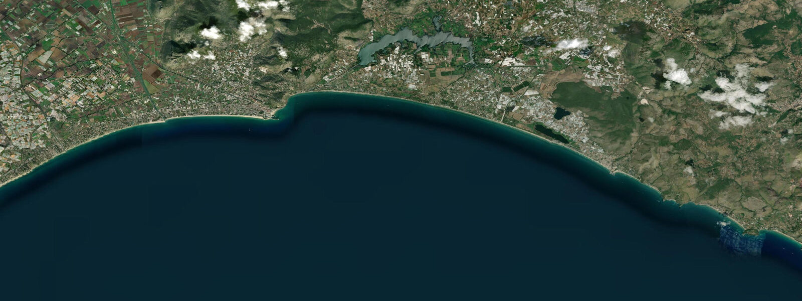
Terracina sits where the Via Appia reaches the Tyrrhenian coast, blocked by the Ausoni hills from pushing further south and forced to skirt them along a narrow coastal strip still called the Passo Anxur. The town has been a port and waystation for two thousand years precisely because of this geography — the first natural harbour south of Rome on the open coast. Above the modern town on a promontory 117 metres high, the Temple of Giove Anxur watches the sea. On clear days the temple terrace is visible from vessels 40 kilometres offshore on the approach from the south — the same landmark that guided shipping in the first century AD.
Tidal range at Terracina is approximately 0.3 metres — microtidal Tyrrhenian standard. The coast here is exposed to southwest and libeccio conditions; the Circeo headland immediately south provides partial shelter for the inner harbour, but the main town beaches are open. Calm mornings after settled high pressure produce the best swimming conditions, particularly at the beaches south of the promontory where the Circeo shadow reduces swell.
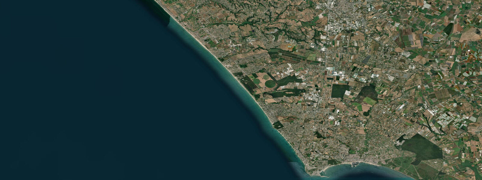
The promontory itself divides old Terracina from the modern resort development to the south. The Roman town — forum, columns, the original paving of the Via Appia — is visible at street level in the historic centre; the black and white mosaic floor of the old forum has been preserved in place and is routinely walked over by residents going about their day, which is the kind of casual cohabitation with antiquity that is distinctively Lazio. The Roman-era canal system that drained the Pontine Marshes — the Canale delle Acque Alte — meets the sea near Terracina at the mouth of the Canale Mussolini (now officially renamed), the Fascist-era drainage infrastructure built on the original Roman alignment.
The sand beaches stretch south from the promontory for several kilometres toward San Felice Circeo. The sea floor transitions from sand to posidonia meadow offshore, and the water quality along the Circeo coastline is consistently high — the Parco Nazionale del Circeo protects the dune and marine environment. Snorkelling off the rocky sections at the Circeo headland, 12 kilometres south, produces better results than the sand beaches.
Sailors entering from the south use the Giove Anxur temple as a bearing mark on the approach, exactly as the Romans did. The small marina at Terracina handles leisure craft; the commercial fishing harbour is adjacent. The town's direct connection to Rome — 100 kilometres up the Via Appia, or 2 hours by regional rail — makes it a day-trip or long-weekend destination for the city rather than a standalone resort.
Predictions on this page come from Open-Meteo Marine, a gridded global ocean model. Accuracy is typically within plus or minus 45 minutes on timing and 0.2 to 0.3 metres on height — model-derived, not from a local gauge. For authoritative Italian tide data, consult ISPRA (Istituto Superiore per la Protezione e la Ricerca Ambientale) through the Rete Mareografica Nazionale.
Tide questions about Terracina
Quick answers to the most common questions about tide times, range, and water access at Terracina.
What is the tidal range at Terracina?
Terracina is on the southern Lazio Tyrrhenian coast, firmly within the Mediterranean's microtidal regime. Spring tidal range is approximately 0.3 metres. Sea level variation for practical purposes is driven by wind: libeccio (southwest) and sirocco (southeast) produce the most significant water level and sea-state changes. The Circeo headland immediately south provides partial shelter; north-facing beaches within the harbour are calmer than the open south-facing beaches during southwest conditions.
Can I visit the Temple of Giove Anxur?
Yes. The Temple of Giove Anxur sits on the promontory 117 metres above the town and is accessible by road or a steep walking path from the historic centre. The site includes the vaulted cryptoportico substructures that supported the temple platform, and an open terrace with unobstructed views south over the Circeo headland and north toward Rome's coastal plain. The temple is the same landmark navigators use on the sea approach — the view explains why it was placed there.
What are the best beaches near Terracina?
The main sandy beaches run south from the Terracina promontory for several kilometres toward San Felice Circeo, backed by pine woods and protected partly by the Parco Nazionale del Circeo. The water quality is good. The rocky sections around the Circeo headland, 12 kilometres south, are better for snorkelling. The beaches north of the promontory face more open-sea conditions and are better suited to conditions when southwest wind and swell are absent.
What is the Pontine Marshes history?
The Pontine Marshes — Agro Pontino — covered the coastal plain between the Alban Hills and the sea from antiquity until the 20th century. Romans attempted drainage in the 1st century BC; Julius Caesar and Augustus both commissioned canal work. The definitive drainage was a Fascist infrastructure project between 1928 and 1935, using modern earthmoving equipment to extend the Roman canal network and establish the five new towns (Latina, Sabaudia, Pontinia, Aprilia, Pomezia) that now dominate the plain. The Canale Mussolini — now officially renamed Canale delle Acque Alte — carries the drainage water to the sea near Terracina.
Are the tide predictions on this page suitable for navigation?
No. Predictions here come from Open-Meteo Marine, a global ocean model providing indicative tide timing and height guidance — not certified nautical data. For passage planning, berthing decisions, or any navigational purpose, use official sources: Italian Hydrographic Institute (Istituto Idrografico della Marina) publications, or ISPRA's Rete Mareografica Nazionale for observed water levels. The Temple of Giove Anxur is a recognised visual bearing mark on charts for the southern Lazio approach, but always navigate with official charts and verified position data.
7-day tide table — Terracina
Heights relative to MSL. Predictions: Open-Meteo Marine (MeteoFrance SMOC, 0.08° grid) — heights relative to MSL (not chart datum / LAT). Model-derived.
| Day | Type | Time | Height |
|---|---|---|---|
| Sun 21 Jun | High | 02:00 | -0.4m |
| Low | 09:00 | -0.7m | |
| High | 15:00 | -0.5m | |
| Low | 20:10 | -0.7m | |
| Mon 22 Jun | High | 03:15 | -0.4m |
| Low | 09:50 | -0.7m | |
| Tue 23 Jun | High | 04:10 | -0.4m |
| Low | 11:00 | -0.6m | |
| Wed 24 Jun | High | 05:00 | -0.4m |
| Thu 25 Jun | Low | 00:00 | -0.6m |
| High | 19:10 | -0.4m | |
| Fri 26 Jun | Low | 01:00 | -0.6m |
| High | 07:00 | -0.4m | |
| Low | 13:00 | -0.6m | |
| High | 19:50 | -0.4m | |
| Sat 27 Jun | Low | 13:50 | -0.6m |