Hendijan tide times
Hendijan tide forecast — heights relative to MSL.
Today's tide times for Hendijan
Tide times at Hendijan on Saturday, 4 July 2026: first low tide at 05:21am, first high tide at 11:21am, second low tide at 06:40pm. Sunrise 05:13am, sunset 07:16pm.
Tide chart for Hendijan
24-hour cosine-interpolated curve around the present moment. Heights relative to MSL. Predictions: Predictions: Open-Meteo Marine (MeteoFrance SMOC, 0.08° grid).
Sun, moon and conditions on Sat 04 Jul
Snapshot at build time — refreshes daily. Sea state from Open-Meteo Marine.
Highs and lows next 7 days
Every predicted high and low for the next week, with the daily tidal coefficient (0–120; higher = bigger swing, > 95 means stronger currents).
Other spots nearby
The three closest curated TideTurtle locations to Hendijan, measured by great-circle distance.
Today's solunar windows
Solunar tradition: major periods are the ≈3h windows around moon transit and opposition; minor are ≈2h around moonrise and moonset. Pair with the local tide stage and wind for the best read.
Cycle dates near Hendijan
Last spring tide on Sat 04 Jul (range 2.5m). Next spring tide on Fri 10 Jul (range 2.0m). Next neap on Thu 09 Jul.
Spring tides cluster around new and full moons (biggest swings). Neap tides land on quarter moons (smallest swings). See the spring tide and neap tide glossary entries for the why.
About tides at Hendijan
A short guide to the coastline at Hendijan — geography, sea state, and what the tide is actually doing under your feet.
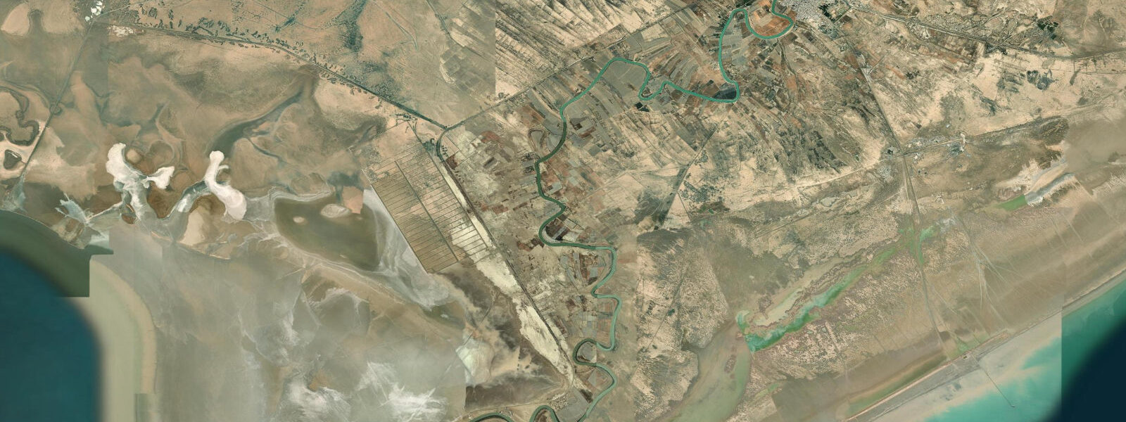
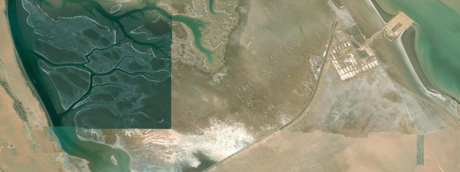
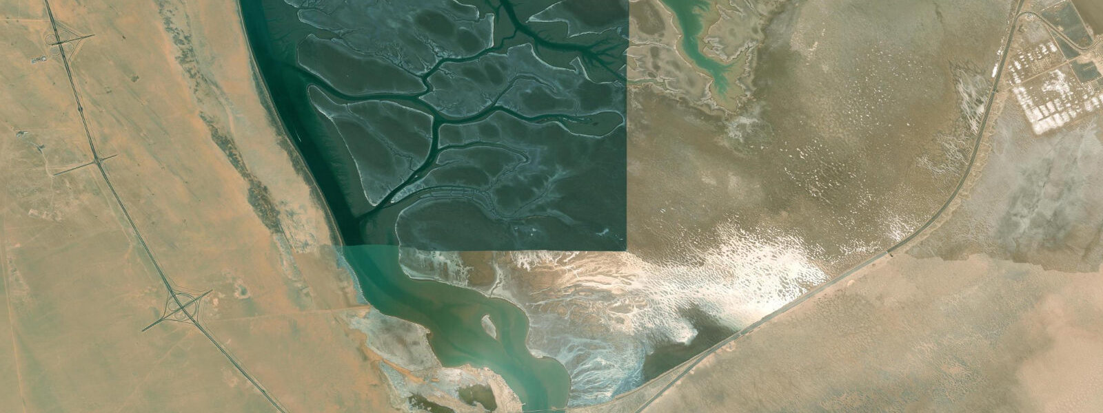
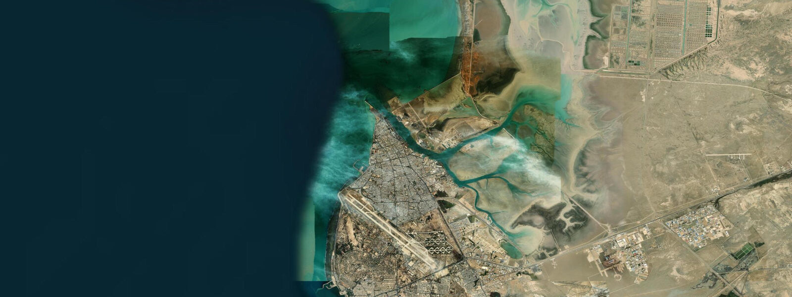
Hendijan is a port and fishing community on the northern Persian Gulf coast of Iran, in Khuzestan Province, west of Bushehr and east of the head of the Gulf where the Shatt al-Arab empties into the sea. The town sits on the edge of a mangrove-lined tidal estuary, one of the few remaining significant mangrove habitats on Iran's Persian Gulf coast. The Hendijan mangrove complex, known locally as the Hendijan Estuary Wetland, is a protected area under the Iranian Department of Environment.
The Persian Gulf at Hendijan has mixed semidiurnal tides with significant diurnal inequality and a spring range of approximately 1.5 to 2.5 metres. Tide predictions here use Open-Meteo Marine's global model, with ±45 minutes timing accuracy and ±0.2 to 0.3 metres height accuracy. The shallow northern Gulf, particularly in the approach to the head of the Gulf near the Shatt al-Arab, amplifies tidal range and wind effects. Shamal events can add 0.5 to 1.0 metres of wind-driven surge on top of the predicted tide.
The mangrove species at Hendijan are the two Gulf mangrove species: Avicennia marina (grey mangrove) and Rhizophora mucronata (loop-root mangrove). These species represent the northern limit of mangrove distribution in the Persian Gulf — the winter water temperatures at this latitude (14 to 17°C at minimum in January and February) approach the cold tolerance threshold for mangrove survival. The Hendijan system has survived and regenerated, making it an important reference point for Gulf mangrove ecology and climate resilience research.
For the fishing community, the tidal channels through the mangrove provide access to the productive shrimp, crab, and fish habitat in the estuary. Traditional kalek (boat) fishing targets shrimp on the ebb tide as the water draws out through the channels, concentrating the crustaceans in predictable locations. The Hendijan shrimp fishery feeds a processing operation that exports to domestic and regional markets.
For birdwatchers, the mangrove and adjacent tidal flat support a productive winter assemblage. The western Iran Gulf coast is on the Central Asian-East African flyway; the Hendijan wetland accumulates waders and waterfowl from October through March. Greater flamingo flocks, grey herons, various cormorant species, and during migration season Palaearctic waders from as far as Siberia pass through.
Access to Hendijan from Ahvaz (the Khuzestan provincial capital) is by the Ahvaz-Bandar Imam highway and then south on the coastal road — a journey of approximately 3 to 4 hours. The town has basic facilities; the mangrove wetland area requires coordination with the local Department of Environment office for access to the protected zones.
The Hendijan estuary has been the subject of research by Iranian marine biologists and international conservation organisations focused on Gulf mangrove ecology. The two Gulf mangrove species present — Avicennia marina and Rhizophora mucronata — show different cold-tolerance thresholds; Avicennia (grey mangrove) is the more cold-tolerant and penetrates furthest north along the Gulf coast, while Rhizophora (red mangrove) is restricted to the warmer south Gulf waters and reaches its northern limit at or near Hendijan. The precise location of this distributional boundary has shifted over time as Gulf winter minimum temperatures have changed.
The shrimp fishery at Hendijan is part of the larger northern Gulf shrimp fishery that extends across the head of the Gulf from Kuwait to the Iranian coast east of Bushehr. The western Iranian Gulf shrimp grounds are managed by the Iranian Fisheries Organisation; catch limits and seasonal closures are set annually based on stock assessment data. The traditional kalek fishing boats operate within the tidal estuary system and in the nearshore Gulf; offshore shrimp trawling requires licensed commercial vessels. The two sectors of the fishery — artisanal and commercial — coexist with periodic tensions over access to the same grounds.
The broader wetland complex around Hendijan extends into the tidal creeks and salt marshes between the estuary and the Bandar Imam Khomeini industrial port to the west. This corridor of coastal wetland, though modified by adjacent industrial infrastructure, retains ecological function as a bird movement corridor along the Gulf coast. Migrating raptors, including the greater spotted eagle and the imperial eagle, have been recorded along the coast in October and November.
Tide questions about Hendijan
Quick answers to the most common questions about tide times, range, and water access at Hendijan.
What is the tidal range at Hendijan?
Hendijan is on the northern Persian Gulf coast in the approach to the head of the Gulf. Mixed semidiurnal tides with significant diurnal inequality; spring range approximately 1.5 to 2.5 metres. The shallow northern Gulf and proximity to the Gulf head amplifies both the tidal range and wind surge effects. Shamal events can add 0.5 to 1.0 metres on top of the predicted tide. Tide data uses Open-Meteo Marine's global model, with ±45 minutes timing accuracy and ±0.2 to 0.3 metres height accuracy.
What makes the Hendijan mangroves ecologically significant?
The Hendijan mangrove complex is at the northern distributional limit of mangroves in the Persian Gulf. Winter water temperatures of 14 to 17°C approach the cold tolerance threshold for the two Gulf mangrove species (Avicennia marina and Rhizophora mucronata). The survival and periodic regeneration of the Hendijan system makes it a reference site for studies of mangrove cold tolerance and Gulf ecological resilience. The mangroves also provide the full suite of ecosystem services: nursery habitat for fish and shrimp, coastal stabilisation, carbon storage, and the tidal flat and creek habitat that supports the western Iran Gulf bird community.
What birds can I see at the Hendijan wetland?
The Hendijan Estuary Wetland is on the Central Asian-East African flyway. Winter assemblages (October through March) include greater flamingo, grey heron, western reef heron, great and little egret, Eurasian spoonbill, various cormorant species, and a range of Palaearctic waders: dunlin, curlew sandpiper, grey plover, bar-tailed godwit, and Eurasian curlew are regularly recorded. October and November bring the widest variety during active migration. Access to the best observation points within the protected zone requires coordination with the Iranian Department of Environment office at Hendijan.
What fish and seafood come from Hendijan?
The Hendijan estuary is a shrimp and fish production area for the northern Persian Gulf. The dominant commercial species is the Indian white shrimp (Penaeus indicus), taken by traditional kalek fishing boats using trawl and bag nets in the tidal channels. Fish species include silver pomfret, grouper, and various bream. The silver pomfret is the most commercially valued finfish species in the northern Gulf market; it is caught by trawl and gill net offshore and processed for fresh and frozen sale. A fish and shrimp processing facility in Hendijan handles the local catch.
How do I get to Hendijan from major Iranian cities?
Hendijan is in Khuzestan Province in southwestern Iran. From Ahvaz (the provincial capital), the journey is approximately 150 kilometres south on the Ahvaz-Bandar Imam highway and then southwest on the coastal road — about 3 to 4 hours by car. From Tehran the journey is 800 kilometres and is done most efficiently by flying to Ahvaz and then driving. From Bushehr to the east, the coastal road runs about 200 kilometres northwest to Hendijan. Foreign visitors require the standard Iranian tourist visa; travel within Khuzestan Province is generally unrestricted for visa holders, though proximity to the Iraqi border in some areas requires attention to current security advisories.
8-day tide table — Hendijan
Heights relative to MSL. Predictions: Open-Meteo Marine (MeteoFrance SMOC, 0.08° grid) — heights relative to MSL (not chart datum / LAT). Model-derived.
| Day | Type | Time | Height |
|---|---|---|---|
| Sat 04 Jul | Low | 05:21 | 0.3m |
| High | 11:21 | 1.6m | |
| Low | 18:40 | -0.9m | |
| Sun 05 Jul | High | 01:21 | 1.0m |
| Low | 06:16 | 0.2m | |
| High | 11:50 | 1.4m | |
| Low | 19:13 | -0.9m | |
| Mon 06 Jul | High | 01:49 | 0.9m |
| Low | 07:08 | 0.0m | |
| High | 12:36 | 1.1m | |
| Low | 19:36 | -0.9m | |
| Tue 07 Jul | High | 02:20 | 0.9m |
| Low | 20:03 | -0.8m | |
| Wed 08 Jul | High | 02:52 | 1.0m |
| Low | 20:36 | -0.6m | |
| Thu 09 Jul | High | 03:23 | 1.1m |
| Low | 10:17 | -0.6m | |
| High | 15:49 | 0.3m | |
| Low | 21:13 | -0.5m | |
| Fri 10 Jul | High | 04:13 | 1.1m |
| Low | 11:36 | -0.8m | |
| High | 17:46 | 0.2m | |
| Low | 21:54 | -0.2m | |
| Sat 11 Jul | High | 02:30 | 0.8m |