Kochi tide times
Kochi tide forecast — heights relative to MSL.
Today's tide times for Kochi
Tide times at Kochi on Friday, 31 July 2026: first low tide at 05:30, first high tide at 12:42, second low tide at 19:12. Sunrise 06:14, sunset 18:48.
Tide chart for Kochi
24-hour cosine-interpolated curve around the present moment. Heights relative to MSL. Predictions: Predictions: Open-Meteo Marine (MeteoFrance SMOC, 0.08° grid).
Sun, moon and conditions on Fri 31 Jul
Snapshot at build time — refreshes daily. Sea state from Open-Meteo Marine.
Highs and lows next 7 days
Every predicted high and low for the next week, with the daily tidal coefficient (0–120; higher = bigger swing, > 95 means stronger currents).
Other spots nearby
The three closest curated TideTurtle locations to Kochi, measured by great-circle distance.
Today's solunar windows
Solunar tradition: major periods are the ≈3h windows around moon transit and opposition; minor are ≈2h around moonrise and moonset. Pair with the local tide stage and wind for the best read.
Cycle dates near Kochi
Last spring tide on Fri 31 Jul (range 1.0m). Next spring tide on Wed 05 Aug (range 0.9m). Next neap on Tue 04 Aug.
Spring tides cluster around new and full moons (biggest swings). Neap tides land on quarter moons (smallest swings). See the spring tide and neap tide glossary entries for the why.
About tides at Kochi
A short guide to the coastline at Kochi — geography, sea state, and what the tide is actually doing under your feet.
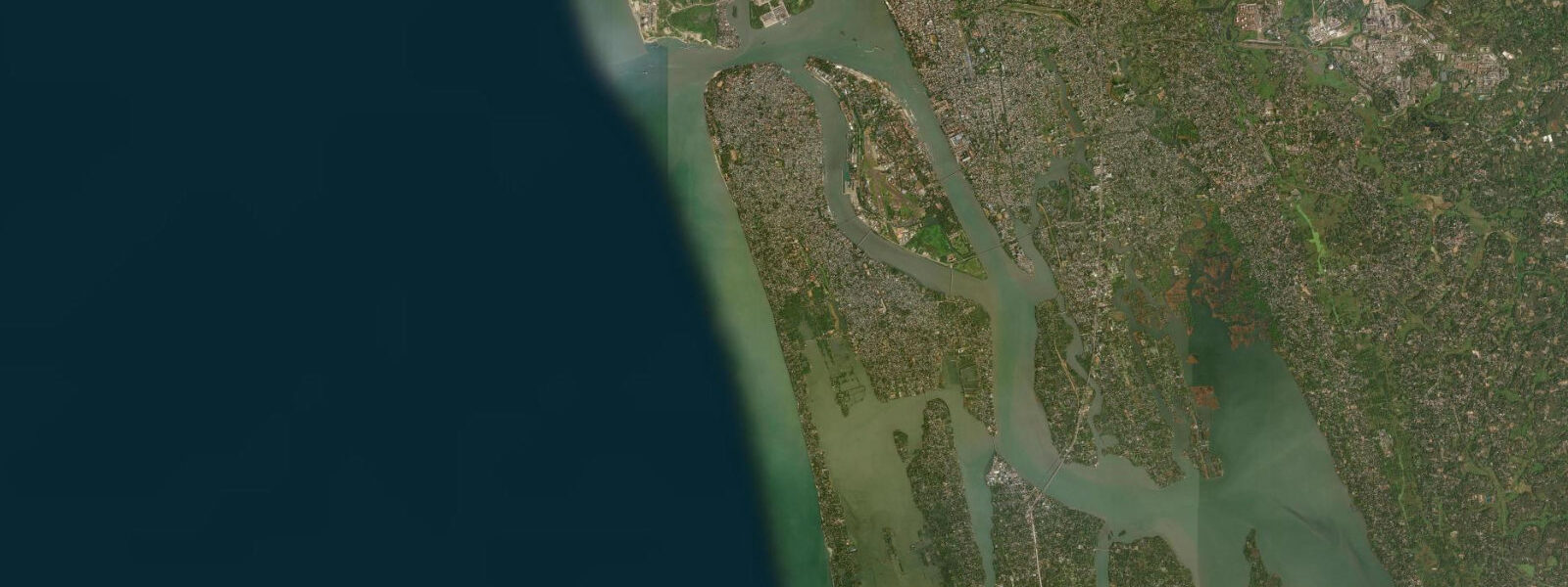
Kochi sits where the Kerala backwaters meet the Arabian Sea, at the mouth of a broad natural harbour formed by the confluence of several rivers and the outer edge of Vembanad Lake. The harbour itself — one of the finest natural ports on the Indian west coast — is accessed through a navigable channel between Vypeen Island to the north and the Fort Kochi headland to the south. Kochi Port handles container traffic, petroleum tankers, and the cruise ships that call seasonally. The fishing harbour at Thoppumpady, a few kilometres south of the commercial port, is among the busiest inshore fishing harbours in Kerala. Both operate with tide in mind, though in different ways.
The tidal regime at Kochi is diurnal with a mixed character. On many days through the month you will see one large high, one smaller high, and two lows of unequal depth — the canonical mixed tide. At other points in the lunar cycle, particularly when the moon's declination is near zero, the pattern approaches two roughly equal highs and two roughly equal lows. Mean spring range is approximately 0.8 to 1.0 metres, placing this firmly in the microtidal category. That is a smaller range than most people associate with the word "tide": the difference between high and low water at Kochi is roughly the height of a large dog. But on a flat estuary coast, 0.8 metres of tidal change shifts the water's edge by tens of metres across the mudflats and sand bars, and through the backwater channels the tidal current is real enough to matter.
The Chinese fishing nets at Fort Kochi — cheena vala — are the most photographed objects on the Kerala coast. They were built to use exactly this tidal current. The counterbalanced cantilever structure lowers a large net flat into the water; the tidal flood or ebb current carries fish over the net; the net is raised sharply, trapping the catch. The nets work best in the couple of hours around the main ebb or flood, when current speed is high enough to concentrate fish against the net face. In the neap period, when the tidal range is compressed and the current slackens, the nets produce less. Experienced operators can tell from the shape of the tidal curve whether a session will be productive before they even lower the net. The Fort Kochi waterfront is lined with these nets, and watching one complete a full cycle — from the deliberate lowering, through the wait in current, to the heaved haul — takes about twenty minutes and is one of the more honest windows into how a tide-dependent fishery actually works.
The backwaters extend north and east from Kochi through Vembanad Lake toward Kottayam and Alappuzha. Houseboat routes through the backwaters cross several lock-and-weir structures where the kaayals open to the sea; these locks are tidal-state dependent for draft-sensitive boats. The shallow channels between paddy islands in Kuttanad — the area called the Rice Bowl of Kerala, farmed below sea level — are managed by bunds and sluices that control tidal inflow for salinity management. The entire Kuttanad system, 50 to 70 kilometres east of Kochi, is in a continuous negotiation with tidal water.
Kayakers and small-boat paddlers find Kochi a workable paddling environment in the right windows. The inner harbour and the backwater channels off Mattancherry and Fort Kochi carry ferry and fishing boat traffic — give way to everything larger, and stay out of the main shipping channel. The flood tide, pushing northeast into the harbour from the sea, makes the outbound paddle toward the open water harder; the ebb makes the return easier. For routes east into the backwaters, the flood carries you inland and the ebb brings you back — a straightforward tidal-assist plan if you time the turn.
Monsoon conditions from June through September change the coast fundamentally. Swell at the harbour mouth reaches two to three metres. Wave heights on the open sea beyond the breakwaters are non-trivial, and the bar between Vypeen Island and Fort Kochi can generate short, steep wave sets when swell meets the ebb current. Fishing boats that work offshore from Kochi during the pre-monsoon and post-monsoon seasons largely shelter in harbour during the southwest monsoon core months. The backwaters, protected from open swell, stay navigable year-round for houseboat and smaller craft — but monsoon river discharge increases salinity intrusion and changes the water quality in the kaayals.
Photographers working the Fort Kochi waterfront should plan for the hour around sunset, when the Chinese fishing nets are backlit against the harbour water and the evening ferry traffic crosses behind them. Low tide exposes more of the mud foreground in front of the nets; high tide brings the water closer. Both work — different compositions, different mood. The fish market adjacent to the Fort Kochi nets opens from the morning catch, the freshness directly tied to what the tide and the current moved into those nets before dawn.
Predictions on this page come from Open-Meteo Marine — a gridded global ocean model — typically within plus or minus 45 minutes on timing and 0.2 to 0.3 m on height, model-derived, not a local gauge. On a coast with a mean spring range of under a metre, that uncertainty is a significant fraction of the total signal. The official tide gauge for Kochi is maintained by the National Hydrographic Office of India; for commercial harbour operations, navigation, and any safety-critical use, consult the NHO or Kochi Port Authority.
Tide questions about Kochi
Quick answers to the most common questions about tide times, range, and water access at Kochi.
When is the next high tide at Kochi?
The next predicted high tide at Kochi, with time shown in India Standard Time (IST, UTC+5:30), appears in the tide table at the top of this page. Kochi follows a mixed diurnal pattern — the number of distinct highs and lows per day shifts through the lunar month, and some days show a single dominant high rather than two clear high-water events. Mean spring range is approximately 0.8 to 1.0 metres. Predictions come from Open-Meteo Marine, typically accurate to within plus or minus 45 minutes on timing and 0.2 to 0.3 m on height — model-derived, not a local gauge. The National Hydrographic Office of India maintains the authoritative Kochi tide record.
What is the tidal range at Kochi and why is it so small?
Mean spring range at Kochi is approximately 0.8 to 1.0 metres, placing it in the microtidal category. The Arabian Sea basin geometry does not amplify the open-ocean tidal signal the way enclosed bays or funnel-shaped estuaries do; there is no resonant amplification pathway here comparable to the Bay of Fundy or the Bristol Channel. The tidal character is mixed diurnal — the pattern shifts between two-high, two-low days and single-dominant-high days as the moon's declination changes through the month. Spring tides around new and full moons push toward the upper end of the range; neap tides at quarter moons compress the swing toward 0.4 to 0.5 metres. Wind-driven setup during the southwest monsoon can exceed the tidal signal entirely.
Where does the tide data for Kochi come from?
Tide predictions on this page come from Open-Meteo Marine, a free global ocean model that estimates tidal heights from hydrodynamic equations applied across a geographic grid. This is not derived from harmonic analysis of a dedicated Kochi gauge record. Accuracy is typically within plus or minus 45 minutes on timing and 0.2 to 0.3 m on height — model-derived, not a local gauge. On Kochi's small-range coast, that model uncertainty is a meaningful fraction of the total predicted swing. The National Hydrographic Office of India and the Kochi Port Authority hold the official gauge data and publish official tide tables for commercial and navigational use.
How do the Chinese fishing nets at Fort Kochi use the tide?
The cheena vala — counterbalanced cantilever nets along the Fort Kochi waterfront — are designed to work the tidal current in the harbour mouth. The large horizontal net is lowered flat into the water; the flood or ebb current concentrates fish over the net surface; the net is then hauled sharply upward, trapping the catch. The two-to-three hours around each tidal turning point, when current speed is near its peak, are the most productive windows. During neap periods, when the tidal range compresses and the current slackens, catches decline. The nets are a practical illustration of how a tide-dependent fishery calibrates to a small but consistent tidal signal.
Can I use these tide predictions for navigation in Kochi Harbour?
No. Predictions on this page are for general planning — understanding the tidal rhythm, timing backwater paddling, knowing roughly when the cheena vala nets are working, scheduling a ferry crossing. They are not charted navigational data. Kochi Harbour is a working commercial port with container vessels, tankers, and ferry traffic. For vessel navigation, bar crossing at the harbour mouth, and under-keel clearance decisions, use the official tide tables from the National Hydrographic Office of India or consult Kochi Port Authority. Open-Meteo Marine predictions carry model uncertainty of plus or minus 45 minutes and 0.2 to 0.3 m — not precision adequate for safe navigational use in a busy commercial port.
8-day tide table — Kochi
Heights relative to MSL. Predictions: Open-Meteo Marine (MeteoFrance SMOC, 0.08° grid) — heights relative to MSL (not chart datum / LAT). Model-derived.
| Day | Type | Time | Height |
|---|---|---|---|
| Fri 31 Jul | Low | 05:30 | -0.2m |
| High | 12:42 | 0.8m | |
| Low | 19:12 | 0.1m | |
| Sat 01 Aug | High | 00:15 | 0.5m |
| Low | 06:15 | -0.1m | |
| Sun 02 Aug | High | 13:20 | 0.8m |
| Low | 19:50 | -0.1m | |
| Mon 03 Aug | High | 01:40 | 0.5m |
| Low | 07:40 | -0.0m | |
| High | 13:49 | 0.7m | |
| Low | 20:24 | -0.1m | |
| Tue 04 Aug | High | 02:30 | 0.5m |
| Low | 08:12 | 0.0m | |
| High | 14:15 | 0.7m | |
| Wed 05 Aug | Low | 08:52 | 0.1m |
| High | 14:37 | 0.7m | |
| Low | 21:35 | -0.3m | |
| Thu 06 Aug | High | 04:30 | 0.5m |
| Low | 09:40 | 0.2m | |
| High | 15:08 | 0.6m | |
| Low | 22:20 | -0.3m | |
| Fri 07 Aug | High | 04:30 | 0.5m |