Port Blair tide times
Port Blair tide forecast — heights relative to MSL.
Today's tide times for Port Blair
Tide times at Port Blair on Saturday, 27 June 2026: first low tide at 12:24. Sunrise 04:58, sunset 17:46.
Tide chart for Port Blair
24-hour cosine-interpolated curve around the present moment. Heights relative to MSL. Predictions: Predictions: Open-Meteo Marine (MeteoFrance SMOC, 0.08° grid).
Sun, moon and conditions on Sat 27 Jun
Snapshot at build time — refreshes daily. Sea state from Open-Meteo Marine.
Highs and lows next 7 days
Every predicted high and low for the next week, with the daily tidal coefficient (0–120; higher = bigger swing, > 95 means stronger currents).
Other spots nearby
The three closest curated TideTurtle locations to Port Blair, measured by great-circle distance.
Today's solunar windows
Solunar tradition: major periods are the ≈3h windows around moon transit and opposition; minor are ≈2h around moonrise and moonset. Pair with the local tide stage and wind for the best read.
Cycle dates near Port Blair
Next spring tide on Thu 02 Jul (range 1.3m). Next neap on Sun 28 Jun.
Spring tides cluster around new and full moons (biggest swings). Neap tides land on quarter moons (smallest swings). See the spring tide and neap tide glossary entries for the why.
About tides at Port Blair
A short guide to the coastline at Port Blair — geography, sea state, and what the tide is actually doing under your feet.
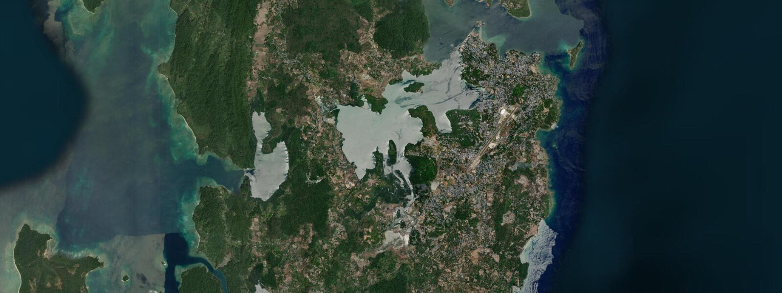
Port Blair is the administrative capital of the Andaman and Nicobar Islands Union Territory, positioned on the southeast coast of South Andaman island where it commands the protected anchorage of the harbour named after William Blair, the British naval surveyor who charted these waters in 1789. The town of roughly 100,000 people is the transit hub for the entire archipelago: the Veer Savarkar International Airport, the main government ferry terminal at Phoenix Bay, and the inter-island boat services to Havelock, Neil, and the Andaman's outer islands all operate through here.
The tidal regime at Port Blair is semidiurnal with a spring range of 3.2–3.8 m — among the largest in India. Two daily tidal cycles of approximately equal height drive strong tidal currents through the narrow passages between South Andaman and the surrounding islands. The Aberdeen Jetty in Port Blair's inner harbour and the Phoenix Bay ferry terminal both operate within a partially enclosed water body where the tidal influence is measurable but moderated. The open harbour and the passage between South Andaman and Rutland Island to the south are where tidal currents are most significant: 2–3 knots at peak spring ebb in the Rutland Strait.
The Cellular Jail — Kala Paani, as the colonial prisoners named it — stands directly on the Port Blair waterfront, its seven radiating wings visible from the harbour approach. Built between 1896 and 1906, it held Indian independence activists in solitary confinement, its isolated island location intended to make escape impossible. The most famous prisoner was Vinayak Damodar Savarkar, imprisoned here 1911–1924. The building is now a national memorial and the mandatory first stop for most visitors to the Andamans. The sea wall below the jail's eastern face is exposed at low spring tides, dropping 2–3 m below the base of the wall to reveal the intertidal rock face and the coral growth that colonises the lower exposed zone. The best photographs of the jail's seafront elevation are taken at low water from a boat or from the waterfront road, when the full height of the sea wall above the water is visible.
For boaters and paddlers, Port Blair's inner harbour is well sheltered at all tidal states. The Aberdeen Jetty handles the fishing fleet and inter-island government ferries; the Chatham Island jetty and boatyard — connected to the mainland by a short causeway — is the departure point for many organised dive and snorkel day trips. The tidal current in the approach channel to the harbour, through the passage east of Chatham Island, runs at 1.0–1.5 knots at peak spring flood and ebb. Kayakers should plan harbour-exit and re-entry around the slack water periods — roughly 30 minutes on either side of high and low water — when the passage current is manageable.
The inter-island ferry services from Phoenix Bay are the critical logistics for any multi-island itinerary. The government ferries (MV Makruzz, MV Havelock) and private launches to Havelock Island operate on fixed timetables that do not adjust for tidal state, but the journey time and sea state on the crossing are affected by tidal current in the passages between islands. On spring tides, the passage current adds or subtracts 15–25 minutes to the 90-minute Havelock crossing. The sea state in the inter-island passages on a spring ebb against a 1.5 m southwest swell can make the crossing rough for those prone to seasickness.
Anglers target grouper, snapper, and barracuda on the offshore reefs accessible by boat from the harbour. The reef system around North Passage Island is productive for bottom-fishing; the 60-minute slack-water window is when baits hold position and bite rates are highest. Shore fishing from the Aberdeen Jetty area and the rocky points around Corbyn's Cove (3 km south of town) is productive on the ebb. Corbyn's Cove — a sheltered sand crescent accessible by road — is the closest family beach to Port Blair, with a snorkeable coral reef offshore at mid-tide and above.
For photographers, the Cellular Jail at dawn — before tourist traffic arrives, with early light on the red-brick facade — and the Phoenix Bay ferry loading are the primary Port Blair subjects. Low water at the Cellular Jail exposes the full seawall height and intertidal rock texture below the jail's base.
All tide predictions for Port Blair come from the Open-Meteo Marine gridded model. Timing accuracy is ±45 minutes; height accuracy is ±0.3 m above Chart Datum.
Tide questions about Port Blair
Quick answers to the most common questions about tide times, range, and water access at Port Blair.
What is the tidal range at Port Blair and how does it affect ferry schedules?
Port Blair's spring tidal range is 3.2–3.8 m, semidiurnal — one of India's largest. Government ferry timetables from Phoenix Bay run on fixed schedules but journey times on the inter-island crossings are affected by tidal current. On spring tides the passage current adds or subtracts 15–25 minutes to the 90-minute Havelock crossing. Sea conditions can be rough when a spring ebb runs against a 1.5 m southwest swell. The flood-tide crossing is generally calmer than the spring ebb crossing. Book the earliest departure (typically 06:00–07:00) to avoid afternoon southwest wind chop. Open-Meteo predictions carry ±45 minutes and ±0.3 m uncertainty.
When is the best time to visit the Cellular Jail and does the tide affect the visit?
The Cellular Jail is most photogenic at dawn before tourist traffic arrives, with early light on the red-brick facade. Low spring water is the best tidal condition for viewing the jail's seafront elevation — the sea wall below the eastern wing drops 2–3 m to the exposed intertidal rock, providing a visual scale that is absent at high water when the sea surface is close to the wall base. The national memorial museum opens at 09:00; the evening sound-and-light show begins around 18:00 and provides a different perspective on the building's scale. The jail's clifftop position means it is visible and photographable at any tidal state, but low water adds the distinctive intertidal rock exposure below the eastern face.
Is Corbyn's Cove suitable for snorkelling and when is the best tidal window?
Corbyn's Cove, 3 km south of Port Blair, is the closest accessible snorkelling reef to the capital. The coral reef immediately offshore is snorkeable from mid-tide upward — low spring water can reduce depth over the outer coral heads to 0.3–0.5 m, making contact with coral likely. The best snorkelling window is 2 hours either side of high water on neap tides, when current is minimal and depth over the reef is 1.5–2.0 m. Visibility is typically 5–10 m — lower than the outer islands (Havelock, Neil) but adequate for reef fish identification. Water temperature is 27–30°C year-round. The beach is suitable for family swimming at mid-tide and above; the surf is gentle in the harbour-facing cove.
What are the tidal current conditions for kayaking in Port Blair harbour?
The approach channel east of Chatham Island runs at 1.0–1.5 knots at peak spring flood and ebb. The inner harbour basin is well sheltered at all tidal states. Kayakers should plan exits and entries through the Chatham passage within the 30-minute slack-water window — when channel current drops below 0.5 knots — on either side of high and low water. The open harbour outside Chatham carries stronger tidal flow and afternoon southwest wind chop; morning paddling before 10:00 is the most practical window. The passage south to Jolly Buoy and Red Skin Islands runs through strong tidal narrows unsuitable for kayaks without expert-level planning.
Where is the best fishing accessible from Port Blair and what tidal conditions work?
Bottom-fishing on the offshore reefs around North Passage Island produces grouper, snapper, and barracuda. The productive window is the 60 minutes around slack water — high or low — when baits hold position rather than sweeping in the current. Shore fishing from the rocky points around Corbyn's Cove on the ebb targets barracuda and jack species along the reef edge. The Aberdeen Jetty area produces snapper on dawn sessions at any tidal state. Boat charters leave from the harbour for half-day and full-day reef trips; most operators time morning departures to reach the reef at the day's first slack water.
8-day tide table — Port Blair
Heights relative to MSL. Predictions: Open-Meteo Marine (MeteoFrance SMOC, 0.08° grid) — heights relative to MSL (not chart datum / LAT). Model-derived.
| Day | Type | Time | Height |
|---|---|---|---|
| Sat 27 Jun | Low | 12:24 | 0.3m |
| Sun 28 Jun | High | 06:35 | 1.3m |
| Low | 13:05 | 0.3m | |
| High | 18:48 | 1.0m | |
| Mon 29 Jun | Low | 00:40 | 0.2m |
| High | 07:06 | 1.3m | |
| Low | 13:36 | 0.2m | |
| High | 19:23 | 1.0m | |
| Tue 30 Jun | Low | 01:15 | 0.1m |
| High | 07:44 | 1.3m | |
| Wed 01 Jul | Low | 01:51 | 0.1m |
| High | 08:20 | 1.4m | |
| Low | 14:40 | 0.1m | |
| High | 20:30 | 1.1m | |
| Thu 02 Jul | Low | 02:25 | 0.1m |
| High | 08:52 | 1.4m | |
| Low | 15:16 | 0.1m | |
| High | 21:04 | 1.1m | |
| Fri 03 Jul | Low | 02:56 | 0.1m |
| High | 09:22 | 1.4m | |
| Low | 15:44 | 0.1m | |
| High | 21:41 | 1.1m | |
| Sat 04 Jul | Low | 03:34 | 0.2m |