Utila, Bay Islands tide times
Utila, Bay Islands tide forecast — heights relative to MSL.
Tide chart for Utila, Bay Islands
24-hour cosine-interpolated curve around the present moment. Heights relative to MSL. Predictions: Predictions: Open-Meteo Marine (MeteoFrance SMOC, 0.08° grid).
Sun, moon and conditions on Sat 27 Jun
Snapshot at build time — refreshes daily. Sea state from Open-Meteo Marine.
Highs and lows next 7 days
Every predicted high and low for the next week, with the daily tidal coefficient (0–120; higher = bigger swing, > 95 means stronger currents).
Other spots nearby
The three closest curated TideTurtle locations to Utila, Bay Islands, measured by great-circle distance.
Today's solunar windows
Solunar tradition: major periods are the ≈3h windows around moon transit and opposition; minor are ≈2h around moonrise and moonset. Pair with the local tide stage and wind for the best read.
About tides at Utila, Bay Islands
A short guide to the coastline at Utila, Bay Islands — geography, sea state, and what the tide is actually doing under your feet.
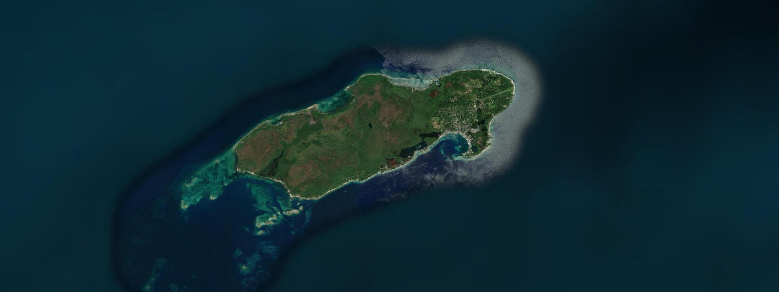
Utila is the smallest and westernmost of Honduras’s three main Bay Islands, sitting 30 km off the north coast of the mainland at the western end of the Bay Islands group. It is also the flattest: the island rises to no more than 4 m elevation at its highest point, a low limestone and mangrove platform that barely breaks the water’s surface. Utila has a reputation as the cheapest place on earth to get a PADI open-water dive certification, and that reputation is more than a decade old — it has driven the entire economy and demographic of the island toward dive instruction, budget accommodation, and a year-round population of travelling divers.
The tidal range at Utila is the same as the rest of the Bay Islands: mixed semidiurnal, spring range 0.3–0.5 m above Chart Datum, neap range 0.1–0.2 m. The island sits on the western end of the Bay Islands ridge and faces the open western Caribbean to the south and west. The main bay — Utila Bay — is on the south coast facing the mainland and is where the ferry from La Ceiba docks and where most of the dive shops, restaurants, and guesthouses cluster along the single main road (the road does not have a formal name; locals call it Main Street).
For dive operations, the tidal considerations at Utila are specific to the site types available. The north-coast wall dives — Black Hills, CJ’s Drop-Off, Ron’s Wreck — are deep-water sites where tidal current is the relevant variable. The north coast faces open Caribbean water and receives a consistent tidal current of 0.5–1.0 knots on springs flowing west-to-east on the flood and reversing on the ebb. Dive operators here run drift dives by design; briefings specify which direction to drift based on the day’s tidal phase. The current at the north wall is more predictable and consistent than the current inside the south coast bay.
For open-water certification students — the main population of divers at Utila — the confined-water training sessions take place in the south-coast bay. The bay is sheltered from northers and from Caribbean swell by the island itself. Depth in the training areas ranges from 3–8 m. Tidal current inside the bay is 0.1–0.3 knots — low enough not to significantly complicate basic skill exercises like mask clearing and regulator recovery. Skills-training on the bay works at any tidal stage; instructors choose dive site location for conditions, not tide.
Whale sharks are Utila’s principal marine attraction beyond the reef. The island sits at the southern edge of the Bay Islands whale shark aggregation zone — whale sharks concentrate in the western Caribbean from March to September, peaking April–May and again August–September. Sightings are from the surface or from a drift dive on the north coast. Tidal state does not reliably predict whale shark presence; the animals follow plankton and baitfish concentrations driven by currents and upwelling, not the astronomical tide. Vessels run dedicated search patterns off the north coast when whale sharks have been reported by other boats.
The east end of Utila — around the small settlement of Pumpkin Hill Bay — is less developed and better for kayaking and independent exploration. The mangrove systems on the island’s western and eastern ends filter the water running off the low limestone surface; the water clarity inside these mangrove channels is lower than on the open reef. The Iron Bound wetlands on the island’s interior support a diverse bird population — herons, egrets, kingfishers — that concentrates along the mangrove channels on the flooding tide when small fish move into the shallow margins.
Anglers working from Utila target snapper and grouper on the south-coast reef structures and pelagic species in the open water to the north and west. The channel between Utila and the next island to the east — Barbareta and Roatan — concentrates current and attracts pelagic predators. Fishing the channel on the spring ebb, when current is running west at 0.8–1.2 knots, is the preferred approach for wahoo and tuna.
All tide predictions for Utila come from the Open-Meteo Marine gridded model. Timing accuracy is ±45 minutes; height accuracy is ±0.3 m above Chart Datum.
Tide questions about Utila, Bay Islands
Quick answers to the most common questions about tide times, range, and water access at Utila, Bay Islands.
What is the tidal range at Utila and how does it affect scuba diving?
Utila has a mixed semidiurnal tidal range of 0.3–0.5 m on spring tides. For open-water certification dives in the south bay (3–8 m), the tidal change is minimal and training sessions run at all tidal stages. For north-coast wall dives — Black Hills, CJ’s Drop-Off — tidal current of 0.5–1.0 knots on springs is the meaningful variable. All north-coast dive operations run planned drift dives; the direction (east or west) is set by the tidal phase on the day. Dive shop briefings specify the current plan. Tide predictions from the Open-Meteo Marine gridded model carry ±45 minutes timing uncertainty and ±0.3 m height uncertainty.
Does tidal state affect whale shark sighting chances at Utila?
Whale sharks at Utila are not reliably predicted by tidal state. The animals aggregate in the western Caribbean from March to September and are tracked by the Whale Shark & Oceanic Research Centre (WSORC) based on real-time vessel reports and plankton surveys. The best correlation with sighting likelihood is surface water temperature, baitfish presence, and whether other boats have reported sightings that morning — not whether the tide is flooding or ebbing. Book a dedicated whale shark search trip through one of Utila’s licensed operators; they radio-coordinate sighting locations in real time.
Is the ferry from La Ceiba to Utila affected by the tide?
The Utila Princess catamaran ferry dock is on the south coast of Utila in 3–5 m of water at mid-tide. The tidal range of 0.3–0.5 m does not reduce dock depth to a level that affects ferry operations under normal conditions. Ferries run approximately twice daily in each direction; confirm current timetables with Utila Princess or your accommodation. Ferry cancellations at Utila are caused by northers — the winter cold fronts that bring rough seas on the 35 km crossing from La Ceiba — not by tidal state. Book flexible passage during November–March when northers are most frequent.
Where do anglers fish from Utila, and does tidal timing matter?
Shore and panga fishing from Utila targets snapper and grouper on the south-coast reef structures at all tidal stages. The most productive tidal window for these reef species is the last two hours of the ebb and the first hour of the flood, when current is low and baitfish concentrate on structure rather than drifting in the current. Pelagic fishing — wahoo, tuna — focuses on the open water north of the island and on the channel between Utila and Roatan. The spring ebb produces the strongest westward current through the inter-island channel (0.8–1.2 knots), which is the preferred condition for trolling wahoo along the current edge.
Is Utila suitable for kayakers and paddlers, and what are the tidal considerations?
The south coast bay is well protected and suitable for kayaking at all tidal stages — current is 0.1–0.3 knots and swell is blocked by the island. The east-end mangrove channels around Pumpkin Hill Bay are an excellent paddle, accessible by kayak on the flood tide when water depth in the channels reaches 0.4–0.8 m. On a spring low, some of the shallower mangrove channels drop below 0.2 m and kayak access is limited to the main channels. The north coast is exposed to Caribbean swell and tidal current; kayaking the north coast is practical only in calm weather and is not recommended for inexperienced paddlers. Rent kayaks from Main Street operators; they will advise on current conditions.
7-day tide table — Utila, Bay Islands
Heights relative to MSL. Predictions: Open-Meteo Marine (MeteoFrance SMOC, 0.08° grid) — heights relative to MSL (not chart datum / LAT). Model-derived.
| Day | Type | Time | Height |
|---|---|---|---|
| Sat 27 Jun | — | ||
| Sun 28 Jun | — | ||
| Mon 29 Jun | High | 07:00 | 0.1m |
| Tue 30 Jun | — | ||
| Wed 01 Jul | Low | 14:50 | -0.0m |
| Thu 02 Jul | High | 22:10 | 0.1m |
| Fri 03 Jul | Low | 16:00 | 0.0m |