Trujillo, Honduras tide times
Trujillo, Honduras tide forecast — heights relative to MSL.
Today's tide times for Trujillo, Honduras
Tide times at Trujillo, Honduras on Friday, 3 July 2026: first low tide at 06:00pm. Sunrise 05:16am, sunset 06:19pm.
Tide chart for Trujillo, Honduras
24-hour cosine-interpolated curve around the present moment. Heights relative to MSL. Predictions: Predictions: Open-Meteo Marine (MeteoFrance SMOC, 0.08° grid).
Sun, moon and conditions on Fri 03 Jul
Snapshot at build time — refreshes daily. Sea state from Open-Meteo Marine.
Highs and lows next 7 days
Every predicted high and low for the next week, with the daily tidal coefficient (0–120; higher = bigger swing, > 95 means stronger currents).
Other spots nearby
The three closest curated TideTurtle locations to Trujillo, Honduras, measured by great-circle distance.
Today's solunar windows
Solunar tradition: major periods are the ≈3h windows around moon transit and opposition; minor are ≈2h around moonrise and moonset. Pair with the local tide stage and wind for the best read.
Cycle dates near Trujillo, Honduras
Next spring tide on Thu 09 Jul (range 0.3m). Next neap on Wed 08 Jul.
Spring tides cluster around new and full moons (biggest swings). Neap tides land on quarter moons (smallest swings). See the spring tide and neap tide glossary entries for the why.
About tides at Trujillo, Honduras
A short guide to the coastline at Trujillo, Honduras — geography, sea state, and what the tide is actually doing under your feet.
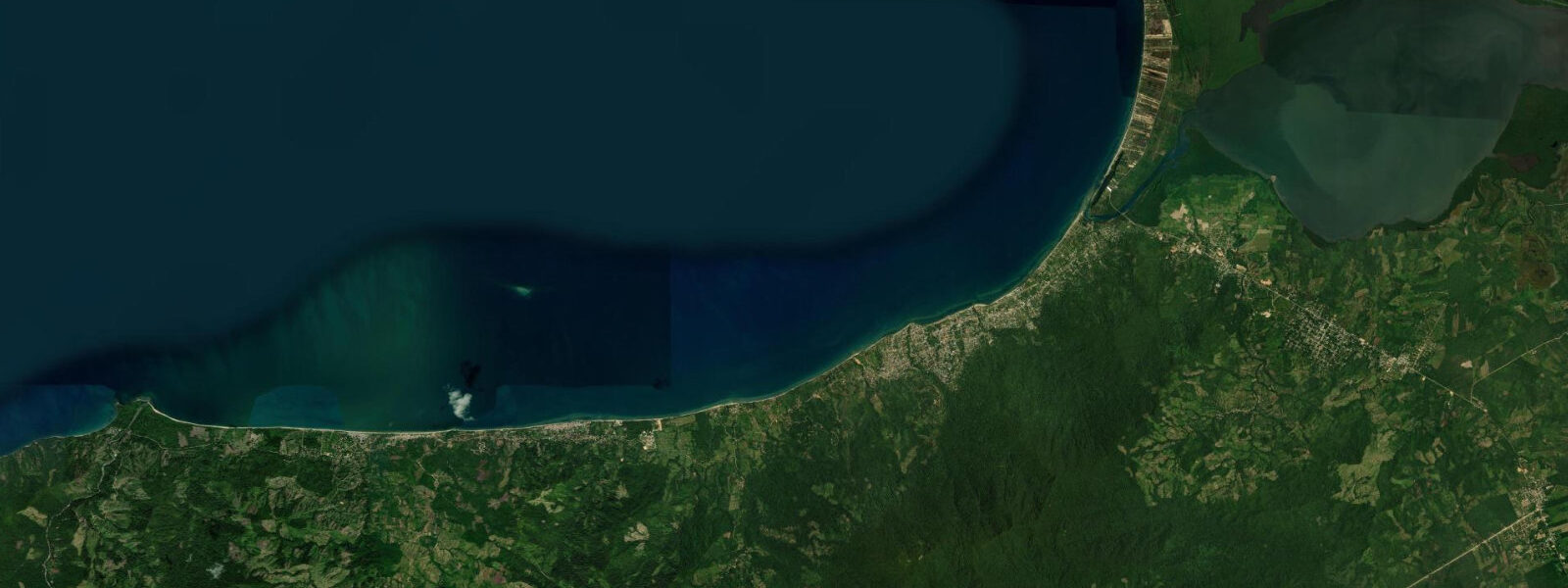
Trujillo occupies a peninsular point above a deep horseshoe bay on the eastern Caribbean coast of Honduras, where the Sierra de Agalta reaches toward the sea. Columbus anchored here on 14 August 1502 during his fourth voyage and the first Catholic Mass in Central America was celebrated on the shore below the current town. The Fortaleza de Santa Bárbara, a Spanish colonial fort built above the town in the 17th century, still stands with its cannon pointing over the bay, a reminder that this was once a strategically contested port.
The tidal pattern is microtidal and mixed semidiurnal. Open-Meteo Marine provides forecast data for Trujillo Bay — timing accuracy ±45 minutes, height accuracy ±0.2–0.3 m. Spring tidal range runs 20–50 cm. The bay's horseshoe shape provides natural shelter from prevailing trades and moderates swell from the north, making water conditions in the inner bay calm for most of the year.
Anglers working the Trujillo Bay waterfront and the river mouths east of town (Río Chapagua, Río Cristales) encounter snook, tarpon, and mangrove snapper, particularly on incoming tides in the wet season. The deep water directly off the Punta Castilla cape — the northeastern headland of the bay — transitions quickly from reef to open Caribbean, and panga charters target barracuda, kingfish, and jack along the structure there.
Kayakers launching from the town beach have access to the full arc of the horseshoe bay, with flat water in the inner section and progressively more exposed conditions toward the two headlands. The mangrove lagoons behind the eastern shore of the bay, accessible by paddling through the break in the sandbar at the river mouths, are a productive bird and wildlife circuit. A circumnavigation of the inner bay takes 3–4 hours under normal conditions.
Beach families use the main town beach, a stretch of grey-brown sand running east from the central dock. The water is calm inside the bay; a gentle slope and mostly sandy bottom make it safe for children. The beach gets heavy local weekend use but is quiet on weekdays outside of school holidays. Water temperature sits around 27–28°C year-round.
Photographers should climb to the fort in the morning for the elevated view across the bay to the Agalta ridge — the fortifications in the foreground, the bay curving away, and the mountains behind give a compressed sense of the geography that is hard to convey from sea level. At water level, the early morning light on the calm bay reflection is clean and unobstructed from the central dock.
Tide timing note: the forecast represents open-water conditions in the outer bay. River mouths on the bay's eastern shore (Río Chapagua, Río Cristales) will show a 20–45 minute lag on the tidal turn, with further attenuation of the range as you move upriver.
Tide questions about Trujillo, Honduras
Quick answers to the most common questions about tide times, range, and water access at Trujillo, Honduras.
What is the historical significance of Trujillo Bay?
Christopher Columbus anchored in Trujillo Bay on 14 August 1502 during his fourth and final voyage to the Americas — the first documented European contact with the Central American mainland. The first Catholic Mass in Central America was celebrated on the shore at Trujillo shortly after. The Spanish built Fortaleza de Santa Bárbara above the town in the 17th century to defend the port against British and Dutch privateers; the fort is now a museum with the original cannon still in place. The American adventurer William Walker was executed in Trujillo in 1860 following his failed attempt to take control of Central America.
What tidal conditions are best for fishing the river mouths near Trujillo?
Incoming tides are the most productive for snook and tarpon at the Río Chapagua and Río Cristales mouths east of town. The rising water pushes bait into the mangrove root systems and concentrates predators at the channel edges. Allow a 20–45 minute lag on the Open-Meteo Marine tide forecast (±45-minute base accuracy, ±0.2–0.3 m height) for the river mouths compared to the open bay. The wet season, May–October, sees the highest river flows and the most reliable tarpon activity. A local guide with a panga makes a significant difference for first-time visitors — the river mouth network is complex and changes after each major flood.
How sheltered is Trujillo Bay during northers?
The horseshoe geometry of Trujillo Bay provides solid protection from northers for the inner anchorage and town beach. The bay opens northeast, and the two headlands — Punta Castilla to the northeast and the lower cape to the northwest — deflect the worst of the north swell. During a strong norther, the outer part of the bay will develop chop and short-period swell, but the town waterfront stays manageable. Small craft should be hauled or moved to the inner dock if a serious front is forecast. The norther season runs November through March, with the highest frequency in December–January.
Is the Fortaleza de Santa Bárbara worth visiting?
The fort sits 200 m above the town on a spur overlooking the bay and is a 20-minute walk from the central dock. The view from the battlements across the bay to the mountain ridges behind is the best elevated perspective available in the area. The museum inside holds a modest collection of Spanish colonial artefacts and explanation panels (Spanish only) covering the conquest-era history of the coast. Original cannon are mounted on the sea-facing walls. Entry fee is nominal and the site is open daily. The walk up is steep — wear shoes with grip and allow 45 minutes for the visit.
What is the sargassum situation at Trujillo Bay beaches?
Trujillo Bay receives sargassum seaweed from the Caribbean circulation, with the heaviest influxes typically occurring May–August, though this varies considerably year to year. The horseshoe bay geometry traps seaweed that enters through the northeastern opening, particularly in the eastern corner. The town beach near the central dock is cleaned periodically by the municipality, but accumulation can be heavy during peak influx periods. The beaches on the outer headlands tend to cycle through heavy deposits and clear spells more quickly because tidal currents and wave action redistribute the material faster than in the sheltered inner bay.
8-day tide table — Trujillo, Honduras
Heights relative to MSL. Predictions: Open-Meteo Marine (MeteoFrance SMOC, 0.08° grid) — heights relative to MSL (not chart datum / LAT). Model-derived.
| Day | Type | Time | Height |
|---|---|---|---|
| Fri 03 Jul | Low | 18:00 | 0.0m |
| Sat 04 Jul | — | ||
| Sun 05 Jul | High | 13:00 | 0.1m |
| Low | 19:10 | 0.0m | |
| Mon 06 Jul | High | 00:50 | 0.1m |
| Low | 20:00 | 0.0m | |
| Tue 07 Jul | High | 15:10 | 0.1m |
| Low | 21:00 | -0.0m | |
| Wed 08 Jul | High | 02:00 | 0.1m |
| Low | 09:00 | -0.1m | |
| High | 17:00 | 0.1m | |
| Low | 22:00 | 0.0m | |
| Thu 09 Jul | High | 03:00 | 0.1m |
| Fri 10 Jul | Low | 10:50 | -0.1m |
| High | 17:00 | 0.2m | |