Ilulissat tide times
Ilulissat tide forecast — heights relative to MSL.
Today's tide times for Ilulissat
Tide times at Ilulissat on Saturday, 27 June 2026: first low tide at 03:26am, first high tide at 08:52am, second low tide at 02:48pm, second high tide at 10:03pm.
Tide chart for Ilulissat
24-hour cosine-interpolated curve around the present moment. Heights relative to MSL. Predictions: Predictions: Open-Meteo Marine (MeteoFrance SMOC, 0.08° grid).
Sun, moon and conditions on Sat 27 Jun
Snapshot at build time — refreshes daily. Sea state from Open-Meteo Marine.
Highs and lows next 7 days
Every predicted high and low for the next week, with the daily tidal coefficient (0–120; higher = bigger swing, > 95 means stronger currents).
Other spots nearby
The three closest curated TideTurtle locations to Ilulissat, measured by great-circle distance.
Today's solunar windows
Solunar tradition: major periods are the ≈3h windows around moon transit and opposition; minor are ≈2h around moonrise and moonset. Pair with the local tide stage and wind for the best read.
Cycle dates near Ilulissat
Next spring tide on Tue 30 Jun (range 2.2m). Next neap on Sun 28 Jun.
Spring tides cluster around new and full moons (biggest swings). Neap tides land on quarter moons (smallest swings). See the spring tide and neap tide glossary entries for the why.
About tides at Ilulissat
A short guide to the coastline at Ilulissat — geography, sea state, and what the tide is actually doing under your feet.
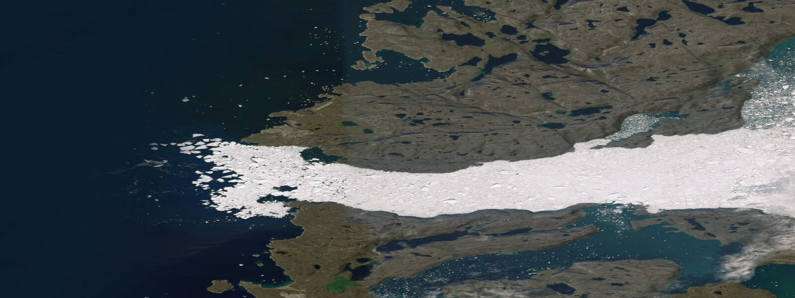
Ilulissat sits on the eastern shore of Disko Bay at 69°N, 350 km north of Nuuk. The town of 4,500 people is the third-largest in Greenland and one of the most visited — the Ilulissat Icefjord (Sermeq Kujalleq) UNESCO World Heritage site lies 40 km south of the town, where the Sermeq Kujalleq glacier, one of the fastest-moving glaciers on Earth, calves icebergs into Kangia Ice Fjord at a rate that makes it the single largest source of icebergs in the Northern Hemisphere. These icebergs drift north out of the fjord mouth and accumulate in the bay south of Ilulissat before breaking loose to drift south down the Davis Strait. The result is a seascape unlike any other: a bay perpetually studded with icebergs ranging from small bergy bits to cathedral-sized tabular bergs.
The tidal regime at Ilulissat is similar to Nuuk: mean range approximately 2.4 m, spring range reaching 3.0–3.2 m, semidiurnal with diurnal inequality. Disko Bay is a large, open embayment and the tidal dynamics are less constricted than in the Nuuk fjord system. Tidal currents around the icebergs in the bay can behave unpredictably — a large grounded berg creates eddy flows on its downstream face, and a rolling or calving berg generates waves of 0.5–2.0 m regardless of tidal state.
Sea ice at Ilulissat is a defining seasonal constraint. Disko Bay freezes over from mid-December to late April in most years, closing the harbour to shipping and making the bay inaccessible to small boats for the ice season. The freezing of the bay creates the dog-sledding season: the flat sea ice is the highway used by local hunters and dog-sled tourism operations. Ice-road travel on sea ice requires local expertise — thickness varies with location and currents; the ice over deep tidal channels remains thin throughout the winter. The ice break-up in April–May is dramatic and unpredictable in timing; year-to-year variation in break-up date of 3–4 weeks is normal.
The iceberg viewing experience at Ilulissat is best from the footpath along the south shore of the Icefjord, which requires a full-day hike from town. The path follows the rocky coastline with icebergs in the fjord visible from above. The tide affects the path's lower sections: at high spring water, several points along the path that cross intertidal rock shelves are submerged to 0.5–1.0 m. Check the tide prediction before starting the hike and plan the lower-shelf sections for the falling or low-tide window.
For boat-based iceberg viewing, Ilulissat's harbour operates year-round except during the sea-ice season. Small-boat tours navigate the outer bay, keeping a safe distance from active bergs — the unstable ones show above-water signs of recent calving (fresh blue ice faces, waterline notching). Tidal currents move icebergs at up to 1.0 knot during spring ebb and flood, and the bay's iceberg traffic makes this a dynamic navigation environment. The harbour approaches are in 5–8 m depth; vessels drawing up to 4.0 m have no tidal restriction in the main approach.
The halibut fishery at Ilulissat is the town's economic foundation. Greenlandic halibut are caught by offshore longline at depth through the winter (including through holes in the sea ice by traditional methods) and by boat in summer. The ebb current through the outer bay is the preferred setting direction for longlines. Arctic char run the rivers accessible from Ilulissat in September–October and are targeted by rod-and-line anglers from the town's river mouths.
All tide predictions for Ilulissat come from the Open-Meteo Marine gridded model. Timing accuracy is ±45 minutes; height accuracy is ±0.3 m above Chart Datum. The model does not account for ice-driven water level anomalies or iceberg-generated waves.
Tide questions about Ilulissat
Quick answers to the most common questions about tide times, range, and water access at Ilulissat.
When is Disko Bay at Ilulissat free of sea ice?
Disko Bay at Ilulissat is typically ice-covered from mid-December to late April — a 4 to 5 month sea-ice season. The harbour itself may freeze earlier in very cold years. Ice break-up in April and May is variable year to year by 3–4 weeks in either direction. During the ice season, shipping is suspended and small-boat tours cannot operate, but dog-sled tours on the sea ice are available. Icebergs calved from the Sermeq Kujalleq glacier are present in and around the bay even after ice break-up and year-round in the outer bay; they are a permanent navigation feature, not seasonal. The ice-free small-boat season runs approximately May through November.
Are the intertidal sections of the Icefjord hiking path safe at all tidal states?
No. Several sections of the Icefjord south-shore hiking path cross rock shelves that are intertidal — at spring high water these sections are submerged to 0.5–1.0 m. The spring tidal range of 3.0–3.2 m means the timing of high water is critical for safe passage on the low-level path sections. Check the Ilulissat tide prediction for the day of your hike and plan the intertidal sections during the falling or low-tide window, not within 2 hours of high water. Allow 45–60 minutes of additional buffer given the Open-Meteo model's ±45 minute timing uncertainty. The hiking path is waymarked but the intertidal crossing points are not formally signed for tidal awareness.
How close can small boats get to icebergs in Disko Bay?
Tour operators at Ilulissat follow a minimum safe distance guideline of 200–300 m from large active icebergs, and 100 m from smaller, stable ones. Icebergs can calve, roll, or split without warning — the above-water mass is 10–15% of the total; when an unstable berg rolls, it displaces its entire submerged volume in seconds, creating waves of 0.5–2.0 m in a 360-degree radius. Tidal currents move icebergs at up to 1.0 knot on spring ebb and flood, which means a berg's position relative to your boat changes constantly. Small-boat drivers read above-waterline signs of instability: fresh blue ice faces, calving notches at the waterline, tilted flat tops. Always use a local guide for iceberg-proximity navigation.
What is the best time of year to visit Ilulissat for iceberg viewing?
The peak iceberg volume in Disko Bay south of Ilulissat occurs in June and July, when the previous winter's calving production has accumulated and the bay is free of sea ice. Continuous daylight — the midnight sun runs from late May to late July at 69°N — means photography is possible at any hour, and the low sun angle at midnight gives exceptional raking light on the ice surfaces. August and September have fewer bergs but better weather reliability and the start of autumn northern lights from mid-August. The ice-free window with boat access runs May through November; December through April is the ice-locked dog-sled season.
What fish species are targeted by anglers at Ilulissat?
Greenlandic halibut (Reinhardtius hippoglossoides) is the economic foundation of the Ilulissat fishery, caught by longline at 400–1500 m depth year-round including through sea ice in winter. Arctic char (Salvelinus alpinus) run the accessible river systems in September–October and are targeted by sport anglers from the town; guided char fishing is available from local operators. Atlantic cod have been historically significant in Disko Bay; populations vary with sea temperature. The ebb tidal current in the outer bay is the preferred setting direction for commercial halibut longlines. Winter ice fishing for halibut through drilled holes in the sea ice is a traditional Greenlandic practice still used by hunters and available as a guided activity.
7-day tide table — Ilulissat
Heights relative to MSL. Predictions: Open-Meteo Marine (MeteoFrance SMOC, 0.08° grid) — heights relative to MSL (not chart datum / LAT). Model-derived.
| Day | Type | Time | Height |
|---|---|---|---|
| Sat 27 Jun | Low | 03:26 | -0.9m |
| High | 08:52 | -0.4m | |
| Low | 14:48 | -1.5m | |
| High | 22:03 | 0.4m | |
| Sun 28 Jun | Low | 04:12 | -1.0m |
| High | 09:45 | -0.4m | |
| Low | 15:27 | -1.5m | |
| High | 22:40 | 0.5m | |
| Mon 29 Jun | Low | 04:53 | -1.1m |
| High | 10:19 | -0.4m | |
| Low | 16:03 | -1.5m | |
| High | 23:11 | 0.6m | |
| Tue 30 Jun | Low | 16:42 | -1.5m |
| High | 23:41 | 0.7m | |
| Wed 01 Jul | Low | 17:15 | -1.5m |
| Thu 02 Jul | High | 00:13 | 0.7m |
| Low | 06:51 | -1.3m | |
| High | 12:06 | -0.4m | |
| Low | 17:45 | -1.5m | |
| Fri 03 Jul | High | 00:45 | 0.7m |
| Low | 18:15 | -1.4m | |
| High | 22:00 | -0.3m |