Paros tide times
Paros tide forecast — heights relative to MSL.
Tide chart for Paros
24-hour cosine-interpolated curve around the present moment. Heights relative to MSL. Predictions: Predictions: Open-Meteo Marine (MeteoFrance SMOC, 0.08° grid).
Sun, moon and conditions on Sat 27 Jun
Snapshot at build time — refreshes daily. Sea state from Open-Meteo Marine.
Highs and lows next 7 days
Every predicted high and low for the next week, with the daily tidal coefficient (0–120; higher = bigger swing, > 95 means stronger currents).
Other spots nearby
The three closest curated TideTurtle locations to Paros, measured by great-circle distance.
Today's solunar windows
Solunar tradition: major periods are the ≈3h windows around moon transit and opposition; minor are ≈2h around moonrise and moonset. Pair with the local tide stage and wind for the best read.
About tides at Paros
A short guide to the coastline at Paros — geography, sea state, and what the tide is actually doing under your feet.
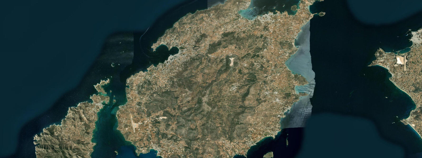
Paros sits at the geographical centre of the Cyclades — equidistant between Mykonos to the north, Santorini to the south, and the islands of Naxos to the east and Sifnos to the west. The island is 196 km² of marble, granite, and windswept plateau, with two completely distinct harbour characters: Parikia on the west coast, the main port and capital, facing the Paros channel and the wind; and Naoussa on the north coast, a smaller, more sheltered bay that was once a pirate refuge and still has the half-submerged ruins of a Venetian castle at the harbour entrance.
The tidal regime at Paros is uniformly Aegean microtidal: spring range approximately 0.2 m above Chart Datum. This is the smallest tidal range of any place in this file — a number that barely registers as a coastal variable. What governs water-level changes at Paros is the Meltemi northerly, the Cyclades' dominant summer weather system. During an established August Meltemi, wind-driven current through the Paros channel (between Paros and Antiparos to the southwest) can run 1.5–2.5 knots; the same system lowers absolute water levels 0.1–0.2 m on the north coast and creates 1.5–2.0 m chop on the exposed northern approaches. Naoussa Bay on the north coast is partially sheltered from the northerly by the headlands flanking its entrance; Parikia harbour on the west is less exposed to the northerly directly but takes fetch from the northwest when the Meltemi veers.
Parikia harbour is the logistical centre of the Cyclades ferry network. More ferries call at Parikia than at any other Cyclades port, and the main jetty — extending several hundred metres into the channel — can handle multiple large ferry vessels simultaneously. The 0.2 m tidal range makes fixed-height ferry berths practical across all tidal states; the operational variable for docking is wind angle, not tide height. The approach to Parikia from the west is exposed to Meltemi chop; ferry captains adjust approach speed and angle according to conditions on arrival.
Naoussa Bay, 8 km north of Parikia, is architecturally the more interesting harbour. The Venetian castle at the harbour entrance is partially submerged — the fortification was damaged in the 1650 Ottoman siege of the island and the lower courses now sit at sea level, with the Aegean moving through the gaps in the foundations on Meltemi-driven surge. The small fishing boats moored inside the harbour entrance pass within metres of the castle ruins on their way in and out. The bay has a small commercial fishing fleet that was active before tourist development and persists alongside it; the 04:00 departures and 10:00 returns of the fishing caiques are the most reliable daily rhythm in the harbour.
Paros is historically the source of some of the world's most prized sculptural marble. The Parian marble quarries in the hills above Marathi village, 8 km from Parikia, were the primary source of marble for classical Greek sculpture from the 7th century BCE onward. The Venus de Milo (now in the Louvre) is Parian marble. Napoleon's tomb in Les Invalides, Paris, uses Parian marble for its inner sarcophagus. The quarries operated continuously until the 19th century and can be visited today; the marble extraction was largely coastal-dependent for export, with the cut blocks moved to the Parikia harbour by ox-cart and loaded onto trading vessels at the quay.
Water sports development at Paros has focused on the Chryssi Akti (Golden Beach) on the southeast coast and the New Golden Beach area — both south-coast locations in the lee of the island during the Meltemi. The steady, consistent northerly wind that makes the north coast uncomfortable for swimming makes the Paros Strait, particularly the Santa Maria area in the northeast of the island, one of the best windsurfing and kitesurfing locations in the Aegean. The Paros World Cup windsurfing event has been held at Golden Beach. The Meltemi timing and strength, not the tidal cycle, governs which days are functional for competition.
The Paros-Antiparos strait, 500 m wide between the two islands, has the strongest ambient current in the immediate Paros area during Meltemi conditions — 1.5–2.5 knots from north to south on established northerly days. Kayakers and small motorboats crossing from Parikia to Antiparos should time the crossing for morning, when the Meltemi has not yet built to its daily maximum. This current has no tidal component.
All tide predictions for Paros come from the Open-Meteo Marine gridded model. Timing accuracy is ±45 minutes; height accuracy is ±0.3 m above Chart Datum.
Tide questions about Paros
Quick answers to the most common questions about tide times, range, and water access at Paros.
What is the tidal range at Paros, and what actually moves the water level here?
Paros has a spring tidal range of approximately 0.2 m — the minimum credible tidal signal in the Aegean. Wind drives all meaningful water-level changes. The Meltemi northerly (June–August) lowers north Cyclades water levels 0.1–0.2 m during sustained northerlies and drives 1.5–2.5 knot currents through the Paros channel. Fixed-height ferry berths at Parikia are functional at all tidal states; the approach condition that matters for ferry captains is wind angle and chop, not tide height. Open-Meteo tide predictions carry ±45 minutes timing uncertainty and ±0.3 m height uncertainty — the height uncertainty is larger than the tidal range itself at this location.
What is the half-sunken Venetian castle at Naoussa harbour?
The Venetian fortress at the entrance to Naoussa Bay dates from the medieval Venetian occupation of Paros (1207–1537) and was damaged in the Ottoman siege of 1650. The lower sections of the fortification have subsided to sea level; the Aegean moves through gaps in the lower foundation courses on every swell event, and at Meltemi surge the castle base is washed. The partially submerged ruins are visible from the fishing boats that pass within metres of the structure on their harbour approach. The castle is accessible by boat from the harbour at low Meltemi states; the upper remaining tower is stable and gives a view back across the bay toward the town.
Is Paros good for windsurfing and kitesurfing, and when is the best season?
Paros is one of the Aegean's best windsurfing and kitesurfing destinations. The Santa Maria area on the northeast coast and Golden Beach (Chryssi Akti) on the southeast are the primary sites. The reliable Meltemi northerly provides consistent 20–30 knot conditions from mid-July through August — the strongest and most predictable period. June has a lower Meltemi frequency but the conditions when it blows are typically cleaner. The Paros World Cup windsurfing event is held at Golden Beach. There is no tidal current to account for; wind strength and direction are the sole planning variables. Beginner-level water sports operate on the calmer south and east coast bays in the mornings before the Meltemi builds.
What is the connection between Paros marble and famous historical monuments?
Parian marble from the Marathi quarries near Parikia was the premium sculptural material of classical Greece — translucent white with very low iron content, prized for its workability and the way light penetrates the surface. The Venus de Milo (Louvre, Paris), the Nike of Samothrace (Louvre), and the Hermes of Praxiteles (Olympia Museum) are all Parian marble. Napoleon's tomb sarcophagus in Les Invalides, Paris, uses Parian marble for its inner lining. The quarries operated from the 7th century BCE through the 19th century CE. They are open to visitors at Marathi village; the ancient quarry tunnel, cut 100 m into the hillside, is accessible with a torch.
How do you get from Parikia to Antiparos, and what current hazards exist in the strait?
The regular small ferry (carnet) from Parikia harbour crosses the 500 m Paros-Antiparos strait in 10 minutes and runs frequently through summer, independent of tidal state. Kayakers and small motorboats making the crossing should do so in the morning, before the Meltemi builds to its daily maximum — the strait current can reach 1.5–2.5 knots from north to south during established northerlies, making the crossing slow and tiring against the flow in the afternoon. There is no tidal component to this current. Antiparos town is 5 minutes walk from the landing point and the island has several accessible beaches within cycling distance of the port.
5-day tide table — Paros
Heights relative to MSL. Predictions: Open-Meteo Marine (MeteoFrance SMOC, 0.08° grid) — heights relative to MSL (not chart datum / LAT). Model-derived.
| Day | Type | Time | Height |
|---|---|---|---|
| Sat 27 Jun | — | ||
| Sun 28 Jun | — | ||
| Mon 29 Jun | Low | 07:00 | -0.5m |
| Tue 30 Jun | High | 04:00 | -0.5m |
| Low | 22:00 | -0.6m | |
| Wed 01 Jul | High | 15:00 | -0.4m |