Ada Foah tide times
Ada Foah tide forecast — heights relative to MSL.
Today's tide times for Ada Foah
Tide times at Ada Foah on Saturday, 4 July 2026: first low tide at 12:00am, first high tide at 06:10am, second low tide at 11:55am, second high tide at 05:42pm. Sunrise 05:48am, sunset 06:15pm.
Tide chart for Ada Foah
24-hour cosine-interpolated curve around the present moment. Heights relative to MSL. Predictions: Predictions: Open-Meteo Marine (MeteoFrance SMOC, 0.08° grid).
Sun, moon and conditions on Sat 04 Jul
Snapshot at build time — refreshes daily. Sea state from Open-Meteo Marine.
Highs and lows next 7 days
Every predicted high and low for the next week, with the daily tidal coefficient (0–120; higher = bigger swing, > 95 means stronger currents).
Other spots nearby
The three closest curated TideTurtle locations to Ada Foah, measured by great-circle distance.
Today's solunar windows
Solunar tradition: major periods are the ≈3h windows around moon transit and opposition; minor are ≈2h around moonrise and moonset. Pair with the local tide stage and wind for the best read.
Cycle dates near Ada Foah
Last spring tide on Sat 04 Jul (range 1.2m). Next spring tide on Fri 10 Jul (range 1.1m). Next neap on Tue 07 Jul.
Spring tides cluster around new and full moons (biggest swings). Neap tides land on quarter moons (smallest swings). See the spring tide and neap tide glossary entries for the why.
About tides at Ada Foah
A short guide to the coastline at Ada Foah — geography, sea state, and what the tide is actually doing under your feet.
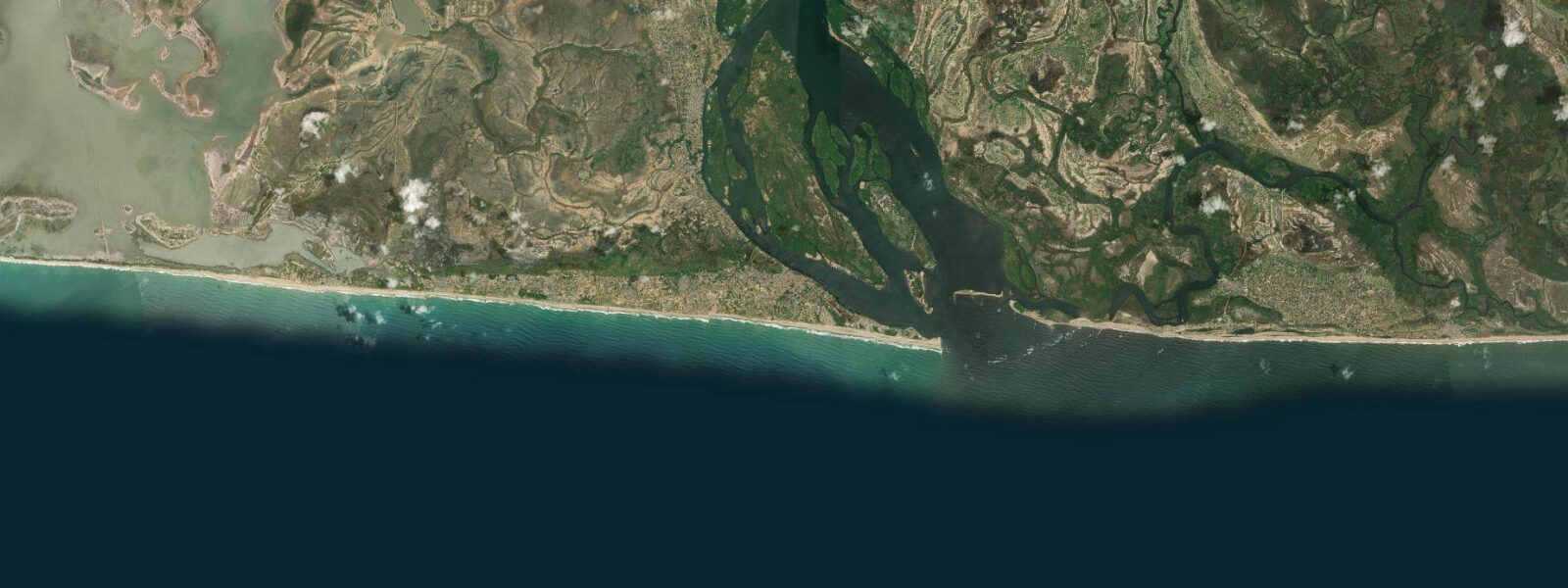
Ada Foah is at the mouth of the Volta River, where West Africa's largest reservoir system finally meets the Atlantic. The river mouth here is not a single defined channel but a shifting delta of sand spits, tidal creeks, and lagoon inlets — a hydraulic junction that produces some of the most complex water conditions on the Ghana coast. On one side of the narrow sand spit is the river; on the other, the Atlantic surf. Both are accessible from the cluster of eco-resorts and lodges that have made Ada Foah one of Ghana's most visited beach destinations.
Tide data for Ada Foah uses Open-Meteo Marine, a global gridded ocean model. Accuracy for this stretch of the Gulf of Guinea coast is typically ±45 minutes on timing and ±0.2 to 0.3 metres on height. The tidal pattern is semidiurnal with a spring range of 0.8 to 1.2 metres — a moderate range by West African standards, with the Gulf of Guinea tending toward the lower end of the West African scale. Wind effects and the Volta's discharge add significant variability on top of the astronomical tide.
The Volta River discharge is the defining variable at Ada Foah. The Akosombo Dam, completed in 1965, fundamentally changed the river's behaviour: before the dam, seasonal flood pulses from the Volta basin reached the river mouth and deposited sand, maintaining the delta spits. Post-dam, reduced sediment load has accelerated coastal erosion, and the river mouth has migrated multiple times. The sand spit that currently separates the river lagoon from the Atlantic is narrower and less stable than it was in the mid-20th century.
For beach users, the Atlantic face of the sand spit at Ada has persistent surf. Tide stage affects the wave character: at low tide the beach gradient steepens and waves dump on the foreshore. At high tide the beach is wider and the waves break further offshore, making conditions gentler for swimming. The river lagoon side is calm and shallow — ideal for kayaking and SUP. Most resorts keep a fleet of canoes and kayaks for guest use.
For anglers, the river mouth zone is highly productive on the outgoing tide. The current flush pushes bait and small fish through the mouth, concentrating predators: ladyfish, barracuda, African moonfish, and the locally prized African threadfin (capitaine) are all caught in this zone. Charter boats operating from the resort jetties run trolling and casting trips into the mouth zone from first light. Shore casting from the river banks is also productive.
Kayaking from Ada Foah into the river delta system is a full-day activity: the network of creeks and lagoon arms extends for several kilometres upstream, with mangrove corridors, fishing villages accessible only by water, and occasional monitor lizard sightings on the banks. Tide planning for these trips matters: entering the creek system on a rising tide and returning on the ebb uses the current efficiently.
Water temperature here runs 26 to 29°C for most of the year, with a cold upwelling period from June through August when Atlantic surface temperatures can drop to 22 to 24°C offshore.
The resort infrastructure at Ada Foah has grown significantly since the early 2000s. Several eco-resort properties operate on the lagoon (river) side of the spit, offering kayak hire, boat excursions, and guided river trips. The standard day-trip format from Accra — 100 kilometres west on the Accra–Tema motorway and then south on the Sogakope road — has made Ada Foah Ghana's most accessible beach and river destination from the capital. Journey time from Accra is approximately 2 hours by private vehicle.
The river mouth zone at Ada Foah is a productive site for observing the interaction between fresh and salt water. On clear days, the colour boundary between the brown Volta water and the blue-green Atlantic is visible from the beach. The mixing zone shifts with tide stage: on the incoming tide, the saltwater wedge pushes upstream under the lighter freshwater; on the ebb, the freshwater layer rides over the denser salt water as it moves toward the sea. This stratification is a significant factor in the ecology of the estuary — juvenile fish use the salinity gradient as a habitat indicator, and adult fish time their movements across the boundary with the tidal cycle.
The Ada Foah Yacht Club and the Ada Estuary Hotel, both on the lagoon side, are the established social and water-sports hubs. Kitesurfing has become a notable activity in the lagoon during the harmattan season (November to February), when the northeast trade wind blows consistently at 15 to 25 knots across the lagoon surface.
Tide questions about Ada Foah
Quick answers to the most common questions about tide times, range, and water access at Ada Foah.
What is the tidal range at Ada Foah?
Ada Foah experiences semidiurnal tides with a spring range of 0.8 to 1.2 metres — on the moderate-to-low end for West Africa's Gulf of Guinea coast. Neap range drops to around 0.3 to 0.5 metres. Predictions use Open-Meteo Marine's global model, with ±45 minutes timing accuracy and ±0.2 to 0.3 metres height accuracy. Actual water levels at the Volta River mouth are also affected by dam-regulated river discharge from Akosombo; during operational releases, river stage can rise by 0.5 metres or more above the tidal baseline on the river side of the spit.
Is Ada Foah safe for swimming?
The lagoon (river) side of the sand spit is calm and suitable for most swimmers at any tide. The Atlantic face has persistent surf and longshore current, and is the riskier option. On the Atlantic beach, swim within two hours of high water when the break is further offshore and the backwash is less turbulent. The river mouth zone itself — where the Volta current meets the Atlantic — has strong unpredictable currents and is not a swimming zone. Most resorts operate on the lagoon side; guests swim in the calm water between the jetties and the opposite bank of the river channel.
Can I kayak in the Volta delta from Ada Foah?
The delta creek system is one of the better kayaking destinations on the Ghana coast. From Ada Foah, multiple channels run westward into the mangrove and lagoon network. Most resorts offer kayak hire; guided tours with local boatmen who know the creek channels are recommended for multi-hour trips. Plan to enter the creek system on a rising tide and return with the ebb — an outgoing tide assists the return passage. The deeper channels are navigable at all tides; some shallow arms dry out or become very restricted at low water. Start early to avoid afternoon heat and afternoon wind chop on the Atlantic face.
How has the Akosombo Dam affected Ada Foah's coastline?
The Akosombo Dam, commissioned in 1965, significantly reduced the Volta River's sediment load. Before the dam, annual floods carried sand to the delta and maintained the coastal spits. Post-dam, sediment starvation has caused persistent erosion at the river mouth and along the adjacent coast. The sand spit at Ada Foah is narrower than it was 60 years ago; some sections have lost several hundred metres of beach width. Dam-regulated releases now control the river stage, with operational releases creating periodic high-water events unrelated to rainfall. The coastline continues to evolve, and beach profiles can change noticeably between visits.
What is the best time of year to visit Ada Foah?
The dry season, November through March, gives the most stable beach conditions and lowest rainfall. December through February is the peak visitor period. The main rainy season runs April through June, with a shorter secondary season in September through October. During the June through August cold upwelling period, Atlantic sea temperatures drop to 22 to 24°C and the river flow may increase due to upstream rainfall; this is the least comfortable period for swimming but can produce good fishing conditions. The resorts operate year-round; most activities — kayaking, fishing, river trips — are available in all but heavy rainfall periods.
7-day tide table — Ada Foah
Heights relative to MSL. Predictions: Open-Meteo Marine (MeteoFrance SMOC, 0.08° grid) — heights relative to MSL (not chart datum / LAT). Model-derived.
| Day | Type | Time | Height |
|---|---|---|---|
| Sat 04 Jul | Low | 00:00 | -0.7m |
| High | 06:10 | 0.5m | |
| Low | 11:55 | -0.3m | |
| High | 17:42 | 0.5m | |
| Sun 05 Jul | Low | 00:08 | -0.6m |
| High | 06:46 | 0.5m | |
| Mon 06 Jul | Low | 00:48 | -0.6m |
| Tue 07 Jul | High | 08:13 | 0.5m |
| Low | 14:36 | -0.4m | |
| High | 20:23 | 0.3m | |
| Wed 08 Jul | Low | 02:23 | -0.4m |
| High | 09:08 | 0.5m | |
| Low | 15:48 | -0.4m | |
| Thu 09 Jul | High | 10:08 | 0.5m |
| Low | 16:54 | -0.5m | |
| High | 23:00 | 0.2m | |
| Fri 10 Jul | Low | 04:42 | -0.4m |
| High | 11:13 | 0.5m | |
| Low | 18:02 | -0.6m | |
| High | 23:00 | 0.2m |