Accra tide times
Accra tide forecast — heights relative to MSL.
Today's tide times for Accra
Tide times at Accra on Saturday, 27 June 2026: first low tide at 12:00am, first high tide at 02:02am, second low tide at 07:22am, second high tide at 01:46pm, third low tide at 08:13pm. Sunrise 05:50am, sunset 06:17pm.
Tide chart for Accra
24-hour cosine-interpolated curve around the present moment. Heights relative to MSL. Predictions: Predictions: Open-Meteo Marine (MeteoFrance SMOC, 0.08° grid).
Sun, moon and conditions on Sat 27 Jun
Snapshot at build time — refreshes daily. Sea state from Open-Meteo Marine.
Highs and lows next 7 days
Every predicted high and low for the next week, with the daily tidal coefficient (0–120; higher = bigger swing, > 95 means stronger currents).
Other spots nearby
The three closest curated TideTurtle locations to Accra, measured by great-circle distance.
Today's solunar windows
Solunar tradition: major periods are the ≈3h windows around moon transit and opposition; minor are ≈2h around moonrise and moonset. Pair with the local tide stage and wind for the best read.
Cycle dates near Accra
Next spring tide on Thu 02 Jul (range 1.3m). Last neap on Sat 27 Jun. Next neap on Wed 01 Jul.
Spring tides cluster around new and full moons (biggest swings). Neap tides land on quarter moons (smallest swings). See the spring tide and neap tide glossary entries for the why.
About tides at Accra
A short guide to the coastline at Accra — geography, sea state, and what the tide is actually doing under your feet.
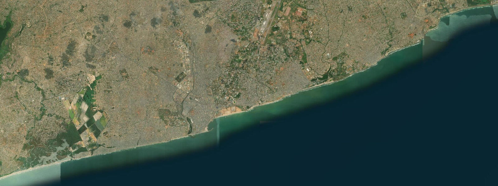
Accra is the capital and commercial hub of Ghana, a city of 2.5 million on the Gulf of Guinea that grew around the cluster of European trading forts built on the coast from the 17th century onward. The city's relationship with the sea is direct and functional: the Jamestown fishing harbour, operating since colonial times directly below the James Fort lighthouse, is one of the most active artisanal fishing landings in West Africa, with a fleet of wooden pirogues — locally called canoes regardless of their actual size — ranging from 6 m hand-paddled vessels to 14 m motorised craft with outriggers and crew of eight.
The tidal regime at Accra is mixed semidiurnal with a spring range of 1.1–1.4 m. The Gulf of Guinea tidal pattern is influenced by the geometry of the continental shelf and the equatorial position: two cycles per day, with moderate diurnal inequality, and a spring range notably smaller than the open Atlantic coast to the north. The range is sufficient to be operationally significant for the fishing fleet and for the shore-fishing access along Accra's rocky coastal sections, but it does not produce the dramatic tidal-flat exposures seen on higher-range coasts.
At Jamestown harbour, the fishing operation runs on a tidal schedule that has been refined over generations. Canoes launch in the late afternoon or evening on the flooding tide, timing departure so the outgoing ebb carries them offshore toward the productive grounds. The catch is landed 5–8 hours later, on the return flooding tide, in the mid-morning. The landing is a coordinated event: the canoe runs through the surf zone stern-first — a technique specific to the surf-landing coasts of Ghana and neighbouring countries — guided by crew members who have jumped into the chest-deep water to hold the hull. Buyers assemble on the beach above the high-water mark, and the fish moves from boat to market in under 30 minutes.
Labadi Beach (La Pleasure Beach) is Accra's main urban beach, 6 km east of Jamestown along the coastal road. The beach is wide, sandy, and backed by the upmarket La Mada Hotel and a strip of weekend bars and food stalls. Entrance fee applies. On weekends, the beach is crowded from 11:00 onward; arriving before 10:00 gives the best swimming conditions: the sea is calmer in the morning before the onshore wind builds, and at mid-tide the beach gradient is at its most forgiving for wading. The current at Labadi runs laterally — longshore drift carries water westward along this section of coast. Swimmers should note that the drift current is persistent and strong enough to displace a swimmer 50 m laterally in 10 minutes; staying near the flags and not swimming north of the marked zone is the practical guidance.
The coastal upwelling from June through September is the defining oceanographic event on the Accra coast. Cold water rises to the surface, sea temperatures drop from 28°C to 22–24°C, and the atmospheric moisture differential creates the Accra coast's characteristic overcast weather during this period (the 'little harmattan' is sometimes used for this cool, grey season, though it is distinct from the Saharan Harmattan of December–February). The upwelling period is the peak fishing season: the cold, nutrient-rich water supports large aggregations of yellowfin tuna, skipjack, and sardinella close to shore, within range of the Jamestown fleet.
For shore anglers, the rocky headlands at Christiansborg Castle (now Osu Castle, the seat of the Ghanaian presidency) and the rock shelf at the James Fort lighthouse base are the most accessible structured fishing positions in the city. The ebb tide concentrates snapper, barracuda, and trevally along these rocky edges. The fishing community at Jamestown is willing to show visiting anglers the productive spots, and the informal knowledge of tidal windows and productive grounds that circulates in the harbour is more accurate than anything written.
The Accra Arts Centre and the Makola Market in central Accra are the two main craft and commerce hubs; neither is tide-dependent, but both are best visited in the early morning before the heat and crowds build. The Kwame Nkrumah Memorial Park, adjacent to the waterfront near the port, provides context for understanding Ghana's post-independence history from its founding president's perspective.
All tide predictions for Accra come from the Open-Meteo Marine gridded model. Timing accuracy is ±45 minutes; height accuracy is ±0.3 m above Chart Datum.
Tide questions about Accra
Quick answers to the most common questions about tide times, range, and water access at Accra.
What is the tidal range at Accra and how does it compare to the Atlantic coast further north?
Accra's spring tidal range is 1.1–1.4 m — roughly half that of the Cape Verde Islands or Senegal's Atlantic coast. The Gulf of Guinea's enclosed geometry and the equatorial position reduce the tidal amplitude relative to the open Atlantic. Neap range drops to 0.4–0.6 m. The 1.1–1.4 m spring range is sufficient to affect fishing operations and rocky-shore access but does not produce dramatic tidal-flat exposures. The main coastal forcing variable for beach conditions at Accra is the offshore swell and the persistent longshore drift current, not tidal amplitude.
How does the Jamestown fishing fleet operate relative to the tide?
Jamestown canoes typically launch in the late afternoon or evening on a flooding tide, using the subsequent ebb to carry them offshore toward the fishing grounds. The return landing occurs 5–8 hours later on the return flood, in the mid-morning. The stern-first surf landing — specific to this coast — involves crew members jumping overboard in chest-deep water to hold the hull as it passes through the breaking waves. The full landing-to-market process takes under 30 minutes. The peak landing activity between 08:00 and 11:00 is the best time to observe the harbour in operation.
What causes the cold sea temperatures along the Accra coast in June through September?
Coastal upwelling driven by the Guinea Current and seasonal wind patterns brings cold, deep water to the surface along the Gulf of Guinea coast from June through September. Sea temperatures drop from 28°C to 22–24°C, and the cool, moist atmospheric conditions create an overcast, grey character to the coast during this period. The cold water drives high fish productivity — this is the peak fishing season on the Accra coast. The cold season ends in October when sea temperatures return to their warm baseline and clearer skies return.
Is Labadi Beach safe for swimming?
Labadi Beach has lifeguard cover on weekends and public holidays, with marked swimming zones. The main hazard is the longshore drift current running westward, strong enough to displace a swimmer 50 m laterally in 10 minutes. Stay within the flagged zone and do not swim in the red-flag sections. The safest swimming is in the morning before the onshore wind builds, at mid-tide when the beach gradient is most gradual. June through September brings the cold upwelling season — sea temperatures drop to 22–24°C, and water clarity can be reduced by the upwelled nutrients.
Where do shore anglers fish in Accra?
The rocky headlands at Osu Castle (Christiansborg) and the rock shelf at the base of the James Fort lighthouse in Jamestown are the most accessible structured shore fishing positions. The ebb tide concentrates snapper, barracuda, and trevally at these rocky points. The longshore current is strong at exposed headlands and requires heavier tackle to keep bait in position. The Jamestown fishing community informally shares knowledge of productive windows and spots; approaching captains at the harbour in the early morning (between landings) is the best way to get specific local guidance.
7-day tide table — Accra
Heights relative to MSL. Predictions: Open-Meteo Marine (MeteoFrance SMOC, 0.08° grid) — heights relative to MSL (not chart datum / LAT). Model-derived.
| Day | Type | Time | Height |
|---|---|---|---|
| Sat 27 Jun | Low | 00:00 | 0.1m |
| High | 02:02 | 0.3m | |
| Low | 07:22 | -0.3m | |
| High | 13:46 | 0.4m | |
| Low | 20:13 | -0.6m | |
| Sun 28 Jun | High | 02:40 | 0.3m |
| Low | 08:02 | -0.4m | |
| High | 14:24 | 0.5m | |
| Low | 20:50 | -0.7m | |
| Mon 29 Jun | High | 03:15 | 0.4m |
| Low | 08:46 | -0.4m | |
| High | 14:55 | 0.5m | |
| Low | 21:21 | -0.7m | |
| Tue 30 Jun | High | 03:50 | 0.4m |
| Low | 22:00 | -0.8m | |
| Wed 01 Jul | High | 04:25 | 0.4m |
| Low | 10:00 | -0.4m | |
| High | 16:02 | 0.5m | |
| Thu 02 Jul | Low | 10:43 | -0.4m |
| High | 16:35 | 0.5m | |
| Low | 23:07 | -0.7m | |
| Fri 03 Jul | High | 05:43 | 0.5m |
| Low | 11:20 | -0.4m | |
| High | 17:10 | 0.5m | |
| Low | 23:00 | -0.7m |