Poti tide times
Poti tide forecast — heights relative to MSL.
Today's tide times for Poti
Tide times at Poti on Saturday, 27 June 2026: first low tide at 04:00am, first high tide at 08:00am. Sunrise 05:38am, sunset 08:53pm.
Tide chart for Poti
24-hour cosine-interpolated curve around the present moment. Heights relative to MSL. Predictions: Predictions: Open-Meteo Marine (MeteoFrance SMOC, 0.08° grid).
Sun, moon and conditions on Sat 27 Jun
Snapshot at build time — refreshes daily. Sea state from Open-Meteo Marine.
Highs and lows next 7 days
Every predicted high and low for the next week, with the daily tidal coefficient (0–120; higher = bigger swing, > 95 means stronger currents).
Other spots nearby
The three closest curated TideTurtle locations to Poti, measured by great-circle distance.
Today's solunar windows
Solunar tradition: major periods are the ≈3h windows around moon transit and opposition; minor are ≈2h around moonrise and moonset. Pair with the local tide stage and wind for the best read.
About tides at Poti
A short guide to the coastline at Poti — geography, sea state, and what the tide is actually doing under your feet.
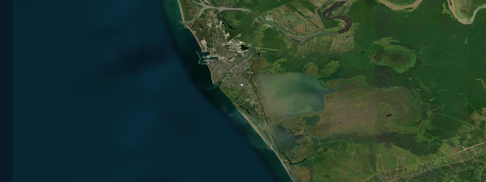
Poti is Georgia's primary commercial port on the Black Sea, 75 km north of Batumi, at the mouth of the Rioni River — the largest river in the Caucasus. The city is defined by this geography: the freshwater plume of the Rioni discharges directly into the Black Sea here, creating a brackish transition zone that extends several kilometres offshore and strongly influences the nearshore environment. The port itself handles container, bulk, and Ro-Ro cargo, and is one of the key logistics nodes for the South Caucasus transit corridor linking Turkey and Azerbaijan. This is not a resort destination. It is a working port city surrounded by lowland forest and wetland.
Water level at Poti is governed by the same principles as the rest of the Georgian Black Sea coast: the astronomical tide is under 10 cm — negligible. Wind setup and atmospheric pressure are the controlling variables, with sustained onshore southwesterlies adding 20–30 cm and offshore winds removing the same. The Rioni River discharge adds a separate freshwater signal: spring snowmelt from the Greater and Lesser Caucasus drives peak river flow in April–June, when the Rioni can discharge 1,200–1,800 cubic metres per second at the mouth. This creates a visible freshwater plume extending 5–10 km offshore, with salinity dropping from the Black Sea mean of 17–18 ppt to under 5 ppt in the river mouth zone. The plume suppresses coastal water temperature by 3–5 °C relative to the surrounding sea in the spring flood period.
For anglers, Poti is one of the most productive locations on the Georgian coast. The Rioni estuary is a feeding ground for Black Sea species that exploit the nutrient-rich freshwater input: mullet (particularly thick-lipped grey mullet) concentrate in the river mouth and the shallow lagoon system behind the port. Black Sea trout — the local brown trout subspecies (Salmo labrax) — enter the lower Rioni on autumn and spring runs. The Paliastomi Lake, 5 km south of Poti and connected to the sea by a narrow channel, holds catfish, carp, and pike alongside the migratory marine species that use the channel. Wind-driven water level changes have some influence on the estuary: an onshore wind that raises the sea level by 20–30 cm backs up the river mouth and slows the outflow, increasing the depth in the estuary channels.
Kayakers should be aware of the shipping traffic at Poti. The approach channels to the commercial port are active and buoyed; small craft must stay well clear of the main fairway. The coast north and south of the city is more accessible for paddling, though the low-lying swampy shoreline offers no landing points for 5–10 km in either direction. The river mouth itself — where the Rioni meets the sea — is navigable by kayak but the current on a spring snowmelt discharge is 3–5 knots in the main channel, requiring care.
For photographers, Poti is raw material rather than a polished subject. The port infrastructure, the river mouth, the wetlands — all offer industrial and natural photography at the interface of a major river and an enclosed sea. The Kolkheti National Park, immediately south of the city, protects the Colchic rainforest and the Paliastomi wetland system; the park's coastal boardwalk provides access to the lake edge and the sea-channel connection.
Swimming is not recommended near the Rioni mouth. The freshwater plume carries silt, river debris, and elevated bacterial counts particularly during high-flow periods. The beaches 3–5 km north of the city, away from the immediate river influence, are cleaner. Sea temperature at Poti tracks the Batumi curve with a 1–2 °C depression in spring due to the cold river discharge.
All tide predictions for Poti come from the Open-Meteo Marine gridded model. Timing accuracy is ±45 minutes; height accuracy is ±0.3 m above Chart Datum. The astronomical tidal signal is under 10 cm here; wind-driven water level changes dominate and are not captured by the tide prediction.
Tide questions about Poti
Quick answers to the most common questions about tide times, range, and water access at Poti.
Is Poti a good place to swim, and how does the Rioni River affect water quality?
Swimming is not recommended near the Rioni River mouth at Poti. The freshwater plume carries suspended silt, river debris, and elevated bacterial loads particularly during spring snowmelt (April–June), when the river discharges 1,200–1,800 cubic metres per second. The plume extends 5–10 km offshore and drops salinity from the Black Sea norm of 17–18 ppt to under 5 ppt at the river mouth. Beaches 3–5 km north of the city, clear of the immediate estuary influence, are significantly cleaner. Sea temperature near the plume is 3–5 °C lower than the surrounding Black Sea in spring due to the cold mountain-fed river water.
What fish species can anglers catch at Poti?
Poti is one of the most productive fishing locations on the Georgian coast. The Rioni estuary concentrates thick-lipped grey mullet year-round; they are most accessible on the shallower edges of the river mouth on calm days when the sea is not pushing water back up the channel. Black Sea trout (Salmo labrax) run the lower Rioni in autumn (October–November) and spring (March–April). Paliastomi Lake, 5 km south, holds catfish, carp, and pike alongside migratory marine species entering through the sea-connecting channel. Bluefish runs in September–October reach Poti as they do Batumi. Wind-driven water level rises that slow the river outflow can concentrate mullet in the estuary shallows.
How does the Rioni River discharge affect the coastal environment at Poti?
The Rioni is the Caucasus's largest river, and its spring snowmelt flood (April–June) discharges 1,200–1,800 cubic metres per second at the Poti mouth. This creates a visible freshwater plume extending 5–10 km into the Black Sea, suppressing salinity, lowering water temperature by 3–5 °C, and carrying suspended sediment that colours the nearshore water brown. The plume is most extensive and intense in May. By August, low-flow conditions reduce the plume to a narrow band at the river mouth. The freshwater discharge is a biological asset — it drives the estuary productivity that makes Poti waters so productive for mullet and migratory fish.
Can kayakers paddle around Poti and what are the hazards?
Kayaking near Poti requires care due to commercial shipping traffic in the port approach channels. The main fairway is marked with buoys; small craft must maintain a wide clearance. The Rioni River mouth is paddleable but spring snowmelt current reaches 3–5 knots in the main channel — feasible for experienced paddlers going upstream but a serious obstacle for novices. The low-lying wetland coast north and south of the city offers no landing points for extended stretches. The Kolkheti National Park south of Poti includes navigable lagoon channels suitable for calm-water kayaking away from the port zone; park management can provide permits and route advice.
Does the Black Sea have tides at Poti, and what drives water level changes?
The astronomical tidal range at Poti is under 10 cm — negligible by any practical standard. The Black Sea's near-enclosed geometry prevents the gravitational tide wave from building to a significant amplitude. Water level at Poti is driven primarily by wind: sustained onshore southwesterlies add 20–30 cm of setup; offshore winds remove the same. The Rioni River discharge adds a secondary signal in spring, when high flow can raise the water level in the estuary channel by 0.2–0.5 m above the coastal sea level. Tide tables here are orientation data only. Weather forecasts from Georgian Hydromet (meteo.gov.ge) are the relevant planning tool for water level.
7-day tide table — Poti
Heights relative to MSL. Predictions: Open-Meteo Marine (MeteoFrance SMOC, 0.08° grid) — heights relative to MSL (not chart datum / LAT). Model-derived.
| Day | Type | Time | Height |
|---|---|---|---|
| Sat 27 Jun | Low | 04:00 | -0.4m |
| High | 08:00 | -0.4m | |
| Sun 28 Jun | — | ||
| Mon 29 Jun | — | ||
| Tue 30 Jun | — | ||
| Wed 01 Jul | — | ||
| Thu 02 Jul | — | ||
| Fri 03 Jul | Low | 19:00 | -0.5m |