Batumi Botanical Garden Coast tide times
Batumi Botanical Garden Coast tide forecast — heights relative to MSL.
Today's tide times for Batumi Botanical Garden Coast
Tide times at Batumi Botanical Garden Coast on Saturday, 4 July 2026: first low tide at 08:00pm. Sunrise 05:43am, sunset 08:51pm.
Tide chart for Batumi Botanical Garden Coast
24-hour cosine-interpolated curve around the present moment. Heights relative to MSL. Predictions: Predictions: Open-Meteo Marine (MeteoFrance SMOC, 0.08° grid).
Sun, moon and conditions on Sat 04 Jul
Snapshot at build time — refreshes daily. Sea state from Open-Meteo Marine.
Highs and lows next 7 days
Every predicted high and low for the next week, with the daily tidal coefficient (0–120; higher = bigger swing, > 95 means stronger currents).
Other spots nearby
The three closest curated TideTurtle locations to Batumi Botanical Garden Coast, measured by great-circle distance.
Today's solunar windows
Solunar tradition: major periods are the ≈3h windows around moon transit and opposition; minor are ≈2h around moonrise and moonset. Pair with the local tide stage and wind for the best read.
About tides at Batumi Botanical Garden Coast
A short guide to the coastline at Batumi Botanical Garden Coast — geography, sea state, and what the tide is actually doing under your feet.
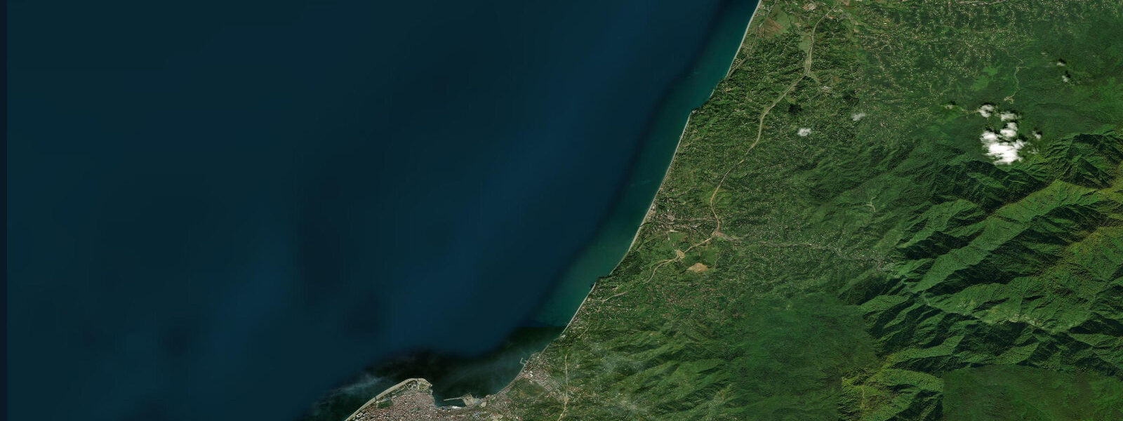
The coast north of Batumi city, from the Mtsvane Kontskhi (Green Cape) headland to the Botanical Garden cliff edge, is the most scenic stretch of the Georgian Black Sea shore accessible from Batumi without a long drive. The Batumi Botanical Garden — founded in 1912 and occupying 113 hectares of south-facing hillside above the Black Sea — is the anchor attraction: subtropical plants from four continents grow on terraced gardens that descend from 100 m elevation to the cliff edge, and paths through the collections lead eventually to the coast, with views south to the Batumi skyline and the towers of the new development on the seafront. The garden's lower section ends above a pebble beach accessible by a path from the garden's coastal gate.
The Green Cape itself, the headland that terminates the coast road north of the botanical garden, is a modest limestone and clay promontory with a lighthouse, a café, and the characteristic Adjaran vegetation — dense subtropical understorey of laurel, rhododendron, and box growing to the cliff edge. The sea below the cape is deep close to shore, and the water clarity here is noticeably better than in the Batumi harbour area to the south, where river inputs from the Chorokhi River affect turbidity.
The Black Sea at this location is microtidal: mean astronomical range 0.1 to 0.2 m. As at all points on the Black Sea, the tidal signal is negligible relative to the meteorological drivers of water level. Wind, seiche, and Black Sea storm surge determine the water level at the cape and garden coast far more than the moon. Summer conditions are typically calm — the prevailing summer wind here is a light sea breeze from the northwest or southwest — and the Black Sea surface temperature at this latitude reaches 24 to 25°C by August. The pebble beach at the garden's coastal gate is swimmable from June through September.
The Adjara highlands visible from the garden coast rise steeply from the shoreline behind Batumi — from sea level to 3,000 m within 50 km. The interaction of the maritime climate and the mountain barrier produces one of the wettest environments in the Caucasus (Batumi averages over 2,500 mm of precipitation annually), and the subtropical forest on the slopes above the botanical garden is a direct consequence of that climatic combination. The garden itself is a living record of the botanical diversity that this Colchic refugium environment supports.
Predictions on this page come from Open-Meteo Marine, a gridded global ocean model. At the 0.1 to 0.2 m astronomical range of the Georgian Black Sea coast, the model's typical accuracy (plus or minus 45 minutes on timing, 0.2 to 0.3 m on height) equals or exceeds the total tidal signal. The Chorokhi River discharge 3 km south can affect the turbidity and current patterns in this nearshore zone after heavy rainfall.
Tide questions about Batumi Botanical Garden Coast
Quick answers to the most common questions about tide times, range, and water access at Batumi Botanical Garden Coast.
When is the next high tide at Batumi Botanical Garden?
The hero block at the top of this page shows the next predicted high in local Georgia Standard Time (GET, UTC+4). Astronomical tide range is 0.1 to 0.2 m — imperceptible at the beach. Water-level conditions here are driven by Black Sea wind and seiche, not the astronomical tide. The beach access at the botanical garden's coastal gate is determined by weather and swell, not by the tide table. The garden is open daily; check the Batumi Botanical Garden website for seasonal hours and entry fees.
What is the tidal range at this coast?
Mean astronomical range is 0.1 to 0.2 m — the standard for the entire Black Sea. The basin has minimal tidal exchange with the Mediterranean through the Turkish Straits. Wind and seiche dominate water-level variation. Autumn and winter northwesterly storms produce the most significant surge events on the Georgian coast; summer is generally calm. The Chorokhi River plume from Batumi harbour 3 km south can affect nearshore water clarity and current near the garden coast after heavy upstream rainfall.
Where do these tide predictions come from?
Open-Meteo Marine, a free gridded global ocean model. For the Black Sea coast's 0.1 to 0.2 m astronomical range, the model's typical uncertainty (plus or minus 45 minutes, 0.2 to 0.3 m) is comparable to or larger than the total signal. The predictions are most useful as a background tidal rhythm reference. For weather and sea-state information on the Georgian coast, the Environment and Climate Change Department of Georgia publishes the authoritative bulletins.
Is there beach access at the Batumi Botanical Garden?
Yes. The botanical garden has a coastal access path that leads to a pebble beach below the cliff at the garden's seaward edge. The beach is accessible through the garden's coastal gate (garden entry fee applies). The path descends steeply from the lower garden terraces; footwear with grip is advisable on the path and on the pebble foreshore. The beach is uncrowded relative to the Batumi city seafront, and the water clarity is better due to distance from the Chorokhi River mouth. Swimmable from June through September.
Is this safe to use for navigation?
No. TideTurtle is a planning tool for recreational coastal activity, not a navigation resource. The Batumi port and approaches carry commercial traffic and require standard chart navigation. The Georgian Maritime Transport Agency and the relevant Black Sea navigational charts are the authoritative sources for vessel operations in Georgian waters. Open-Meteo Marine gridded predictions do not replace authoritative navigation sources.
7-day tide table — Batumi Botanical Garden Coast
Heights relative to MSL. Predictions: Open-Meteo Marine (MeteoFrance SMOC, 0.08° grid) — heights relative to MSL (not chart datum / LAT). Model-derived.
| Day | Type | Time | Height |
|---|---|---|---|
| Sat 04 Jul | Low | 20:00 | -0.4m |
| Sun 05 Jul | High | 01:10 | -0.3m |
| Mon 06 Jul | Low | 21:00 | -0.4m |
| Tue 07 Jul | — | ||
| Wed 08 Jul | — | ||
| Thu 09 Jul | — | ||
| Fri 10 Jul | High | 19:00 | -0.4m |