Moorea tide times
Moorea tide forecast — heights relative to MSL.
Today's tide times for Moorea
Tide times at Moorea on Friday, 26 June 2026: first high tide at 02:00pm, first low tide at 05:10pm. Sunrise 06:29am, sunset 05:34pm.
Tide chart for Moorea
24-hour cosine-interpolated curve around the present moment. Heights relative to MSL. Predictions: Predictions: Open-Meteo Marine (MeteoFrance SMOC, 0.08° grid).
Sun, moon and conditions on Fri 26 Jun
Snapshot at build time — refreshes daily. Sea state from Open-Meteo Marine.
Highs and lows next 7 days
Every predicted high and low for the next week, with the daily tidal coefficient (0–120; higher = bigger swing, > 95 means stronger currents).
Other spots nearby
The three closest curated TideTurtle locations to Moorea, measured by great-circle distance.
Today's solunar windows
Solunar tradition: major periods are the ≈3h windows around moon transit and opposition; minor are ≈2h around moonrise and moonset. Pair with the local tide stage and wind for the best read.
Cycle dates near Moorea
Next spring tide on Wed 01 Jul (range 0.3m). Last neap on Fri 26 Jun.
Spring tides cluster around new and full moons (biggest swings). Neap tides land on quarter moons (smallest swings). See the spring tide and neap tide glossary entries for the why.
About tides at Moorea
A short guide to the coastline at Moorea — geography, sea state, and what the tide is actually doing under your feet.
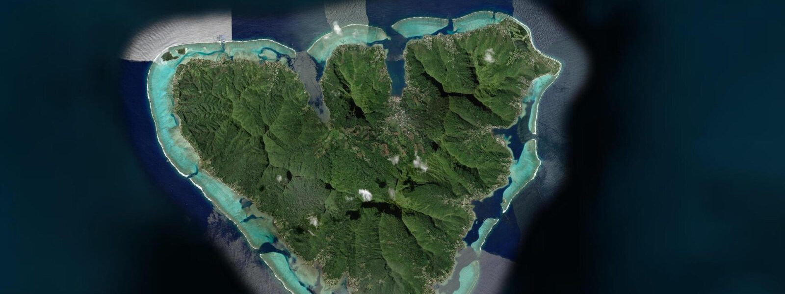
Moorea sits 17 kilometres west of Tahiti across the Sea of the Moon — a passage that the Aremiti ferry crosses in 30 minutes. From the air Moorea's profile is a broken shark's tooth: the island's volcanic origins expressed in the twin bays, Cook's Bay and Opunohu Bay, that cut 3–4 kilometres inland from the north coast, surrounded by mountains that peak at 1,207 m on Mount Tohiea. The barrier reef encircles the island with a handful of passes; the lagoon is wider on the north and west sides, where the main resorts and dive centres operate.
The tidal range at Moorea follows the Society Islands pattern: spring range 0.4–0.5 m, mixed semidiurnal. The two daily high waters and two daily low waters are unequal; the full spring range is compressed into a pattern where the highest water is 0.3 m above Chart Datum and the lowest is 0.1 m below. For the practical user, the 0.4 m swing matters most on the reef flat and in the heads of the two bays, where water depth over coral or sand dictates whether a paddle board can navigate without grounding.
Cook's Bay and Opunohu Bay define Moorea for boaters. Both are entered from the north through barrier reef passes — Cook's Bay Pass serves the ferry terminal at Vaiare and the charter fleet; Opunohu Bay Pass is quieter and more scenic. Pass currents in both run 1.0–2.0 knots outbound when ENE trades are sustained, reversing only briefly around astronomical high water. The bay heads are calm regardless of ocean swell — the passage geometry is too enclosed for swell to penetrate.
For divers, Moorea has a documented humpback whale population that uses the lagoon for breeding and calving from July to October. The whales enter through the passes and move between the bays and the outer lagoon. Tidal state influences whale positioning indirectly: outbound pass current in the afternoon pushes the whales toward the inner bay anchorages; incoming or slack water in the morning allows them to feed in the deeper water near the pass mouths. Dive operators run specific whale-watching snorkel trips during this season; conditions are most productive on calm mornings at or after high water.
For kayakers, Moorea's lagoon is excellent and varied. The 60-kilometre perimeter paddle is a two-day circuit with camping possible on beach pull-outs on the south coast. The most scenic single-day section is the north coast between the two bay passes — approximately 15 km round trip from Cook's Bay — with the mountain profile as a backdrop for the full passage. The inner bay paddle from the Cook's Bay ferry quay to the head of the bay is 4 km in flat, protected water, suitable for beginners. Tidal current in the main lagoon channel adds 0.2–0.4 knots to or against the passage depending on direction and tidal state.
For families, the beach at Temae on the northeast corner of the island is the best public sand beach: wide, shallow, and reef-protected. At low water the inner reef flat shallows to 0.4–0.6 m over the coral-sand bottom — ideal wading depth for children. At high spring water the same flat deepens to 0.8–1.0 m. The snorkelling off the reef edge at the corner of the Temae flat is reliable year-round, with visibility of 10–20 m in calm conditions.
Anglers target the pass edges for trevally and wahoo, and the outer ocean drop-off for yellowfin tuna. The Cook's Bay Pass ebb carries baitfish out of the bay at dusk; this concentration draws trevally that can be caught from the channel bank on jigs or live bait from a small boat anchored off the buoys. The inner bay anchorage at the head of Cook's Bay holds a permanent population of mullet and juvenile snapper that respond to bread or small bait from the quay.
Photographers have two signature views: the sunrise shot of the twin peaks from the north coast road above the barrier reef, and the in-water whale encounter during the July-October season. The north coast road shot is best from 05:45 to 07:00, when the first light catches the upper flanks of Tohiea and Mouaroa without overexposing the lagoon below. A 200 mm telephoto from the road pulls the mountains against the reef and ocean background without requiring a boat.
All tide predictions for Moorea come from the Open-Meteo Marine gridded model. Timing accuracy is ±45 minutes; height accuracy is ±0.3 m above Chart Datum.
Tide questions about Moorea
Quick answers to the most common questions about tide times, range, and water access at Moorea.
What is the tidal range at Moorea and how does it affect access to the reef flat?
Moorea's spring tidal range is 0.4–0.5 m, mixed semidiurnal. On the reef flat at Temae beach and along the north coast, this range shifts water depth by 0.3–0.5 m over the shallowest coral and sand areas. At low neap water, exposed coral heads in 0.3–0.4 m require careful navigation by kayak and SUP. At high spring water, those same heads have 0.7–0.9 m of cover — comfortable snorkelling depth. The model predictions carry ±45 minutes timing and ±0.3 m height uncertainty; always allow extra margin over the shallowest reef areas rather than relying on exact predicted depths.
When do humpback whales visit Moorea and how do tides affect where they are in the lagoon?
Humpback whales use Moorea's lagoon for breeding and calving from July through October, entering through the barrier reef passes from the open Pacific. Outbound pass currents in the afternoon push the whales toward the protected inner bays; mornings at or after high water, when pass flow is slowest, allow the whales to range toward the deeper outer lagoon near the pass mouths. Dive operators offering snorkel encounters typically depart at 07:00–08:00 to catch this morning window. Sightings are not guaranteed by tidal state — whale position also depends on feeding, socialising, and mother-calf bonding behaviour that overrides tidal patterns.
How do you kayak between Cook's Bay and Opunohu Bay and what are the conditions?
The paddle between Cook's Bay and Opunohu Bay along Moorea's north coast is approximately 7 km one way, within the reef-enclosed lagoon. The route passes resort pontoons and reef heads at 0.5–2.0 m depth. ENE trade winds create a beam-to-quartering chop of 0.2–0.4 m on the exposed northern section between the two bay mouths — manageable for intermediate paddlers in sea kayaks or large-volume SUPs. The lagoon channel between the two passes runs a tidal current of 0.2–0.4 knots; plan to paddle the exposed section with the wind at the back (east to west) in the morning before the trades build. Return in the late afternoon when wind typically drops.
What is the best beach for families at Moorea and what tidal conditions are ideal?
Temae beach on the northeast corner is Moorea's best public beach: wide, sandy, and sheltered by the barrier reef. The inner reef flat here is 0.4–0.6 m deep at low water and 0.8–1.0 m at high water — both manageable for children who can stand. The higher-water neap conditions offer the most comfortable wading: deep enough to swim, shallow enough for confident non-swimmers. The reef edge snorkelling 100–150 m from shore is accessible on any tidal state but most comfortable at high water when the swim out does not involve navigating shallow coral heads. Sunscreen not rated reef-safe should be avoided — Moorea's reef is a protected area.
Where is the best fishing at Moorea and what conditions produce results?
The Cook's Bay Pass channel edge at dusk is the top shore-accessible fishing location at Moorea — the ebb current carries baitfish out of the bay, and giant trevally of 3–8 kg follow. Anchor a small boat 30 m off the south channel buoy and cast jigs or live bait into the current seam at the 60-minute window centred on the outbound peak flow. For offshore fishing, the drop-off to oceanic depth begins 1–2 km outside each pass; yellowfin tuna and mahi-mahi are caught trolling year-round at these depths, most productively in the early morning (06:00–09:00). The head of Cook's Bay holds mullet and juvenile snapper accessible from the quay with basic gear at any tidal state.
7-day tide table — Moorea
Heights relative to MSL. Predictions: Open-Meteo Marine (MeteoFrance SMOC, 0.08° grid) — heights relative to MSL (not chart datum / LAT). Model-derived.
| Day | Type | Time | Height |
|---|---|---|---|
| Fri 26 Jun | High | 14:00 | 0.7m |
| Low | 17:10 | 0.6m | |
| Sat 27 Jun | High | 23:50 | 0.8m |
| Sun 28 Jun | Low | 06:00 | 0.6m |
| High | 11:50 | 0.8m | |
| Low | 18:00 | 0.6m | |
| Mon 29 Jun | High | 00:10 | 0.8m |
| Low | 06:10 | 0.6m | |
| High | 12:10 | 0.8m | |
| Tue 30 Jun | — | ||
| Wed 01 Jul | Low | 06:50 | 0.6m |
| High | 13:00 | 0.8m | |
| Low | 19:00 | 0.6m | |
| Thu 02 Jul | High | 01:00 | 0.8m |
| Low | 07:00 | 0.6m | |
| High | 13:15 | 0.8m | |