Alexandria tide times
Alexandria tide forecast — heights relative to MSL.
Today's tide times for Alexandria
Tide times at Alexandria on Wednesday, 29 July 2026: first low tide at 05:00pm, first high tide at 11:10pm. Sunrise 06:14am, sunset 07:58pm.
Tide chart for Alexandria
24-hour cosine-interpolated curve around the present moment. Heights relative to MSL. Predictions: Predictions: Open-Meteo Marine (MeteoFrance SMOC, 0.08° grid).
Sun, moon and conditions on Wed 29 Jul
Snapshot at build time — refreshes daily. Sea state from Open-Meteo Marine.
Highs and lows next 7 days
Every predicted high and low for the next week, with the daily tidal coefficient (0–120; higher = bigger swing, > 95 means stronger currents).
Other spots nearby
The three closest curated TideTurtle locations to Alexandria, measured by great-circle distance.
Today's solunar windows
Solunar tradition: major periods are the ≈3h windows around moon transit and opposition; minor are ≈2h around moonrise and moonset. Pair with the local tide stage and wind for the best read.
Cycle dates near Alexandria
Next spring tide on Sun 02 Aug (range 0.2m). Last neap on Wed 29 Jul. Next neap on Fri 31 Jul.
Spring tides cluster around new and full moons (biggest swings). Neap tides land on quarter moons (smallest swings). See the spring tide and neap tide glossary entries for the why.
About tides at Alexandria
A short guide to the coastline at Alexandria — geography, sea state, and what the tide is actually doing under your feet.
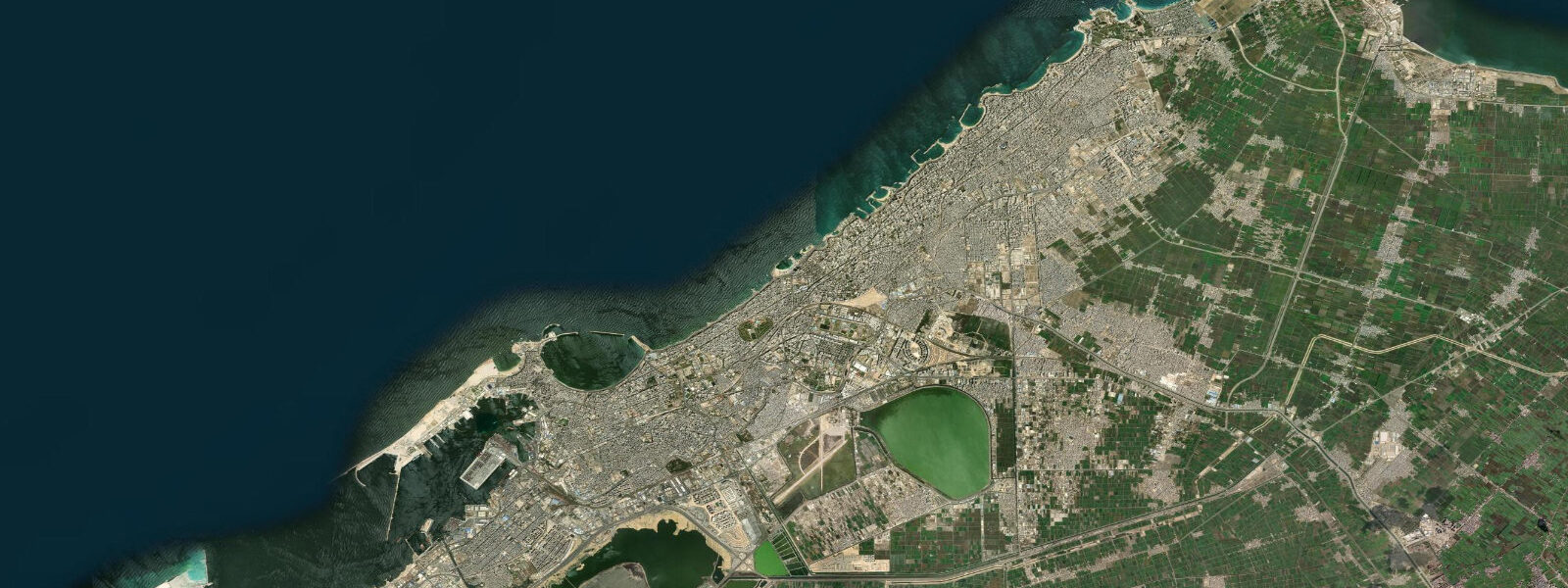
Alexandria spreads along the eastern Mediterranean coast of Egypt where the Nile delta gives way to a long limestone shelf that runs west toward Marsa Matruh and the Libyan border. The city's geography is set by two harbours and the curved Corniche between them. The Eastern Harbour, the natural curve of water in front of the city centre, holds the small fishing fleet at Anfoushi and the Citadel of Qaitbay on the old Pharos peninsula at the harbour mouth — the fortress built in the 1480s on the foundation of the ancient lighthouse, one of the Seven Wonders of the ancient world.
The Western Harbour, larger and protected by long breakwaters, handles the commercial port traffic that has been Alexandria's economic engine for two thousand years. Between them, the Corniche sweeps east past Stanley Bridge, the arched promenade structure over Stanley Beach, and continues toward Sidi Gaber, Glymenopoulo, and the Montaza palace gardens. East of Montaza the coast turns into the long sandy stretch toward Abu Qir Bay, where the Nile delta begins and where the Battle of the Nile in 1798 played out across the bay's outer roadstead.
West of the Citadel of Qaitbay, the Corniche bends past the Anfoushi fishing-boat harbour and the smaller swimming bays at El Mandara before the coast straightens and runs west past Agami toward the limestone-shelf beaches at Sidi Krir and Marina El Alamein. This is microtidal Mediterranean coast. The astronomical tide range at Alexandria is roughly 25 to 30 cm in mean conditions; even the largest spring tides rarely push beyond 35 cm.
The Mediterranean is nearly enclosed — the Strait of Gibraltar at its western end is too narrow to transmit much of the Atlantic tidal energy, and by the time the residual signal reaches the eastern basin off Egypt the astronomical tide is essentially negligible. What moves the water along the Corniche, into the Eastern Harbour, against Stanley Bridge, and over the limestone reef shelves at Glymenopoulo is wind and atmospheric pressure. A winter storm crossing the Mediterranean — the Cyprus and Levantine lows that develop between October and March — can push surge along the Alexandria coast 30 to 50 cm above the predicted level, several times the entire predicted tide range, and in the opposite direction in the wake of the same system.
That distinction is operationally important: for the small-boat fishing fleet at Anfoushi, the harbour-front swimming culture at Stanley Beach and Mandara, the long-line fishermen working the limestone reef west of Agami, and the port-pilotage operations at the Western Harbour, the weather forecast and the synoptic pressure pattern matter much more than the predicted tide. The Egyptian Hydrographic Department operates the gauge network along the Egyptian Mediterranean coast and publishes the authoritative sea-level and surge data — the source of record for any operation that depends on precise water level. The longshore current along the Alexandria coast runs predominantly west to east, driven by the Levantine basin circulation and modulated by the prevailing wind, and that current keeps the long beaches at Glymenopoulo and Mandara in their familiar shape year on year despite the absence of a meaningful tidal flush.
Predictions on this page come from Open-Meteo Marine, a gridded global ocean model. The model estimates tidal height across a geographic grid rather than from harmonic analysis at a calibrated gauge. 3 metres on height.
On a microtidal coast with mean range under 30 cm, that height uncertainty equals or exceeds the entire predicted astronomical signal. Use the model rhythm to know when high water and low water roughly fall, and weight the Egyptian Hydrographic Department real-time gauge and surge forecasts heavily for any actual planning that turns on precise water level.
Tide questions about Alexandria
Quick answers to the most common questions about tide times, range, and water access at Alexandria.
When is the next high tide at Alexandria?
The hero block at the top of this page shows the next predicted high at Alexandria in local Egypt Standard Time (EET, UTC+2, no DST). The astronomical tide range at Alexandria is small — about 25 to 30 cm in mean conditions — so the 'high' and 'low' labels describe a very small water-level difference. What actually drives water level along the Alexandria Corniche, in the Eastern Harbour, and around the Citadel of Qaitbay is wind and atmospheric pressure. The Egyptian Hydrographic Department publishes authoritative sea-level and surge forecasts for the Egyptian Mediterranean coast — check them for any activity that depends on precise water level.
Why is the tide range so small at Alexandria?
The Mediterranean is nearly enclosed. The Strait of Gibraltar at its western end is too narrow to transmit much of the Atlantic tidal energy, and the eastern Mediterranean basin off Egypt sits at the far end of that already-attenuated signal. The astronomical tide reaching Alexandria is reduced to a mean range of 25 to 30 cm. The Mediterranean's own resonance generates a small residual tide, but it is easily swamped by wind-driven setup. Winter Cyprus and Levantine low-pressure systems regularly push water levels 30 to 50 cm above or below the predicted line — several times the entire predicted tide range.
Where do these tide predictions come from?
Open-Meteo Marine, a free gridded global ocean model. The model estimates tidal height from oceanographic equations applied across a geographic grid rather than from harmonic analysis of a dedicated Alexandria gauge record. Accuracy is typically within plus or minus 45 minutes on timing and within roughly 0.2 to 0.3 metres on height. On a microtidal coast like Alexandria, the model's height uncertainty equals or exceeds the entire predicted astronomical signal. For authoritative Egyptian Mediterranean coast tide and surge data, the Egyptian Hydrographic Department is the source of record.
When can I swim safely at Stanley Beach and the Eastern Harbour?
The summer season from May through October brings calm Mediterranean conditions to the Alexandria coast and consistent swimming weather along Stanley Beach, Mandara, and the Eastern Harbour swimming bays. The autumn and winter months from November through March bring the Mediterranean low-pressure systems and frequent storm surge along the Corniche — water levels and sea state can change quickly with the synoptic pattern. The astronomical tide is too small to matter for swimming planning. Check the wind and wave forecast and the Egyptian Hydrographic Department surge bulletins, not the predicted tide table, for storm-season swimming decisions.
Is this safe to use for navigation?
No. For port pilotage at the Alexandria Western Harbour, the Eastern Harbour fishing-boat basin at Anfoushi, or any vessel operation along the Egyptian Mediterranean coast, use the Egyptian Hydrographic Department authoritative tide and surge tables and Egyptian Maritime Affairs and Safety Authority Notices to Mariners. Open-Meteo Marine gridded predictions do not replace gauge-calibrated harmonic data for navigational use, and on a microtidal storm-driven coast the actual water level frequently differs from the predicted level by a larger margin than the entire astronomical tide.
8-day tide table — Alexandria
Heights relative to MSL. Predictions: Open-Meteo Marine (MeteoFrance SMOC, 0.08° grid) — heights relative to MSL (not chart datum / LAT). Model-derived.
| Day | Type | Time | Height |
|---|---|---|---|
| Wed 29 Jul | Low | 17:00 | -0.4m |
| High | 23:10 | -0.2m | |
| Thu 30 Jul | Low | 05:00 | -0.3m |
| High | 11:10 | -0.1m | |
| Fri 31 Jul | Low | 18:00 | -0.4m |
| Sat 01 Aug | High | 00:10 | -0.2m |
| Low | 18:50 | -0.4m | |
| Sun 02 Aug | High | 12:50 | -0.2m |
| Low | 19:10 | -0.4m | |
| Mon 03 Aug | High | 01:10 | -0.2m |
| Low | 07:00 | -0.4m | |
| High | 13:10 | -0.2m | |
| Low | 19:45 | -0.4m | |
| Tue 04 Aug | — | ||
| Wed 05 Aug | High | 02:00 | -0.2m |