Manta, Ecuador tide times
Manta, Ecuador tide forecast — heights relative to MSL.
Today's tide times for Manta, Ecuador
Tide times at Manta, Ecuador on Saturday, 4 July 2026: first high tide at 06:03am, first low tide at 12:06pm, second high tide at 06:03pm. Sunrise 06:25am, sunset 06:29pm.
Tide chart for Manta, Ecuador
24-hour cosine-interpolated curve around the present moment. Heights relative to MSL. Predictions: Predictions: Open-Meteo Marine (MeteoFrance SMOC, 0.08° grid).
Sun, moon and conditions on Sat 04 Jul
Snapshot at build time — refreshes daily. Sea state from Open-Meteo Marine.
Highs and lows next 7 days
Every predicted high and low for the next week, with the daily tidal coefficient (0–120; higher = bigger swing, > 95 means stronger currents).
Other spots nearby
The three closest curated TideTurtle locations to Manta, Ecuador, measured by great-circle distance.

Today's solunar windows
Solunar tradition: major periods are the ≈3h windows around moon transit and opposition; minor are ≈2h around moonrise and moonset. Pair with the local tide stage and wind for the best read.
Cycle dates near Manta, Ecuador
Next spring tide on Sat 04 Jul (range 2.0m). Last neap on Fri 03 Jul. Next neap on Tue 07 Jul.
Spring tides cluster around new and full moons (biggest swings). Neap tides land on quarter moons (smallest swings). See the spring tide and neap tide glossary entries for the why.
About tides at Manta, Ecuador
A short guide to the coastline at Manta, Ecuador — geography, sea state, and what the tide is actually doing under your feet.
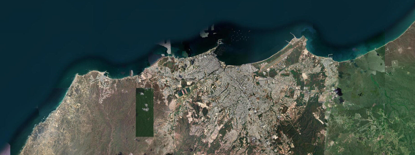
Manta is Ecuador's principal fishing port and Pacific maritime hub — a working city of 250,000 people where the tuna-fishing fleet operates from one of the largest fishing harbours in South America, and artisanal fishers at Tarqui Beach land catch on the same beach where tourists walk. The contrast defines Manta: a productive, functional port economy operating alongside a beach tourism sector, the two sharing shoreline in a way that few places manage without conflict.
The tidal regime at Manta is Pacific semidiurnal with a spring range of approximately 2.0 to 2.5 metres — the same regime as the rest of Ecuador's Pacific coast, with two clear highs and two lows per day. The 2.0 to 2.5 m range produces a visibly wider and narrower beach through the day and a current at the harbour entrance and the river mouth south of the fishing port that is significant enough to plan boat operations around. The predicted incoming tide (flood phase) is when current runs into the port from the southwest; the ebb flows out to the west-northwest.
Tarqui Beach, on the south side of the Manta headland below the main commercial district, is the artisanal fishing beach. The catch comes in from around 09:00, when the offshore pangas return from overnight and pre-dawn trips; the fish are sorted and sold directly on the beach, with pelicans and frigate birds competing for scraps in the immediate vicinity of the boats. The scene is practical and unsentimental. At low tide — the 2.0 to 2.5 m spring low exposing the full sand flat — the beach is wide, the boats are hauled further up, and the fish handling area is expansive. At high tide, the water approaches the seawall and the available beach narrows.
Murciélago Beach, on the north side of the headland, is Manta's recreational swimming and surf beach. The orientation (northwest-facing) receives less direct Pacific swell than south-facing Tarqui, and the break is gentler on most days. The swimming beach runs 1.5 km in front of the hotel strip; the 2.0 to 2.5 m tidal range means the walk from the high-water mark to the water's edge changes by 50 to 80 m through the day on the gently sloping beach.
Whale watching is the marine activity that draws most visitors with a specific ecological interest. Humpback whales migrate northward from their Antarctic feeding grounds through Ecuadorian waters from June through September (peak July–August), and the Manta coast is one of the most reliable observation areas on the Ecuador Pacific. The offshore seamount topography concentrates the whales in predictable zones; licensed whale-watching operators out of Manta's Tarqui Beach run 4-hour morning tours, departing on the outgoing tide when sea state is calmest. Breaching, fin-slapping, and mother-calf pairs are all documented regularly.
The MUCE (Museo de las Culturas del Ecuador Antiguo) in Manta's civic centre holds one of Ecuador's most significant pre-Columbian collections from the Manta culture, which dominated Ecuador's Pacific coast from approximately 500 CE to the Spanish conquest. The Manta people were accomplished maritime traders and navigators; the museum's balsa-sailing canoe reconstructions and the extensive ceramic collection are among Ecuador's best pre-Columbian displays.
Anglers in Manta target two primary zones. The artisanal boats out of Tarqui work the inshore reef structure for pargo (snapper), mero (grouper), and carite on the incoming tide, returning before the afternoon Pacific wind picks up. Charter boats out of the main harbour target offshore mahi-mahi and wahoo in the current lines 20 to 50 km offshore, with larger pelagics — blue marlin, striped marlin — concentrated around the offshore banks in the August–November season.
Predictions on this page come from Open-Meteo Marine, a global gridded ocean model. Accuracy is ±45 minutes on timing and ±0.2 to 0.3 metres on height. INOCAR (Ecuadorian Naval Oceanographic Institute) publishes the authoritative tidal tables for Manta and the Manabí coast.
Tide questions about Manta, Ecuador
Quick answers to the most common questions about tide times, range, and water access at Manta, Ecuador.
When is the next high tide at Manta?
The predicted next high tide at Manta is shown at the top of this page in Ecuador Standard Time (ECT, UTC-5). Spring range is approximately 2.0 to 2.5 metres — Pacific semidiurnal. The tidal cycle visibly changes the beach width at Tarqui and Murciélago by 50–80 m between high and low. Predictions come from Open-Meteo Marine (gridded, ±45 min / ±0.2–0.3 m); INOCAR publishes the authoritative harmonic tables for the Ecuadorian Pacific coast.
When is the humpback whale watching season at Manta?
Humpback whales migrate through Ecuadorian Pacific waters from June through September, peaking in July and August. Licensed whale-watching operators out of Manta run morning tours from Tarqui Beach. The most productive windows are the calmer morning hours before the Pacific afternoon wind builds; outgoing tide in the morning typically produces the smoothest sea state. Advance booking in July–August is recommended as tour capacity fills.
What happens at Tarqui Beach every morning?
Tarqui Beach is Manta's artisanal fishing landing. From around 09:00, pangas return from overnight and pre-dawn trips and land catch directly on the beach. The fish are sorted, iced, and sold on the spot — or to the fish market vendors immediately adjacent. Pelicans and frigatebirds attend every landing. At the predicted low tide, the full sand flat is exposed and the landing zone extends; at high tide the boats come further up the beach. It is one of the few places in Ecuador where the working fishing economy is directly visible at beach level without a tour.
What are the best tide conditions for swimming at Murciélago Beach?
Murciélago Beach's 2.0 to 2.5 m tidal range means the waterline moves 50–80 m through the day. The lower half of the tidal cycle exposes the widest sand area and the gentlest water entry — the most comfortable conditions for casual swimming. At high water, the beach is narrower and the surf breaks closer to the hotel area. The morning hours (before the Pacific afternoon wind) produce the calmest surface conditions regardless of tide state.
Is this safe to use for navigation?
No. TideTurtle is a planning tool, not a nautical almanac. Navigation into Manta's commercial fishing harbour, along the approaches from the west, and around the inshore reef structures requires current INOCAR charts and the relevant Ecuadorian nautical publications. The 2.0–2.5 m tidal range produces significant current at the harbour entrance. Open-Meteo Marine predictions are not a substitute for authoritative harmonic data for any vessel operation.
7-day tide table — Manta, Ecuador
Heights relative to MSL. Predictions: Open-Meteo Marine (MeteoFrance SMOC, 0.08° grid) — heights relative to MSL (not chart datum / LAT). Model-derived.
| Day | Type | Time | Height |
|---|---|---|---|
| Sat 04 Jul | High | 06:03 | 1.4m |
| Low | 12:06 | -0.4m | |
| High | 18:03 | 1.2m | |
| Sun 05 Jul | Low | 00:16 | -0.6m |
| High | 06:40 | 1.4m | |
| Low | 12:48 | -0.4m | |
| High | 18:46 | 1.2m | |
| Mon 06 Jul | Low | 00:56 | -0.5m |
| High | 07:19 | 1.4m | |
| Low | 13:35 | -0.3m | |
| High | 19:33 | 1.2m | |
| Tue 07 Jul | Low | 01:38 | -0.4m |
| High | 08:01 | 1.4m | |
| Low | 14:24 | -0.3m | |
| High | 20:26 | 1.1m | |
| Wed 08 Jul | Low | 02:27 | -0.3m |
| High | 08:52 | 1.4m | |
| Low | 15:18 | -0.4m | |
| High | 21:26 | 1.1m | |
| Thu 09 Jul | Low | 03:26 | -0.3m |
| High | 09:50 | 1.3m | |
| Low | 16:18 | -0.4m | |
| High | 22:33 | 1.1m | |
| Fri 10 Jul | Low | 04:33 | -0.3m |
| High | 10:52 | 1.3m | |
| Low | 17:26 | -0.5m |