Avarua, Cook Islands tide times
Avarua, Cook Islands tide forecast — heights relative to MSL.
Today's tide times for Avarua, Cook Islands
Tide times at Avarua, Cook Islands on Friday, 3 July 2026: first high tide at 02:00pm, first low tide at 05:50pm, second high tide at 11:55pm. Sunrise 07:17am, sunset 06:09pm.
Tide chart for Avarua, Cook Islands
24-hour cosine-interpolated curve around the present moment. Heights relative to MSL. Predictions: Predictions: Open-Meteo Marine (MeteoFrance SMOC, 0.08° grid).
Sun, moon and conditions on Fri 03 Jul
Snapshot at build time — refreshes daily. Sea state from Open-Meteo Marine.
Highs and lows next 7 days
Every predicted high and low for the next week, with the daily tidal coefficient (0–120; higher = bigger swing, > 95 means stronger currents).
Other spots nearby
The three closest curated TideTurtle locations to Avarua, Cook Islands, measured by great-circle distance.
Today's solunar windows
Solunar tradition: major periods are the ≈3h windows around moon transit and opposition; minor are ≈2h around moonrise and moonset. Pair with the local tide stage and wind for the best read.
Cycle dates near Avarua, Cook Islands
Next spring tide on Thu 09 Jul (range 0.6m). Last neap on Fri 03 Jul. Next neap on Tue 07 Jul.
Spring tides cluster around new and full moons (biggest swings). Neap tides land on quarter moons (smallest swings). See the spring tide and neap tide glossary entries for the why.
About tides at Avarua, Cook Islands
A short guide to the coastline at Avarua, Cook Islands — geography, sea state, and what the tide is actually doing under your feet.
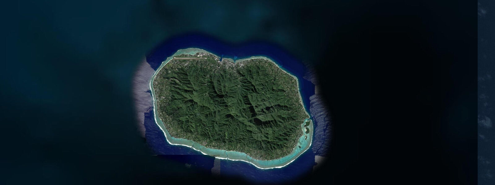
Avarua is the capital of the Cook Islands — a small waterfront town on Rarotonga's north coast holding the country's parliament, central market, and the island's main harbour. With a population of roughly 5,000, it is the commercial centre of a self-governing nation in free association with New Zealand, spread across 15 islands scattered across 2.2 million square kilometres of the South Pacific.
The tidal regime at Avarua is mixed semidiurnal with a spring range of 0.5 to 0.8 metres. Two unequal highs and two unequal lows occur each day. That range is small — among the lower quarter globally — which means Avarua's harbour approach conditions are driven more by swell state and wind than by tidal height. The fringing reef on Rarotonga's north coast sits 100 to 300 metres offshore of Avarua, with the harbour channel cut through the reef as the main boat access. Tidal water moves through this passage on the flood and ebb; the harbour inside the reef is calmer and significantly less tidal than the open lagoon channel between reef and shore. Tide data for Avarua comes from Open-Meteo Marine, a global gridded ocean model. Accuracy is typically ±45 minutes on timing and ±0.2 to 0.3 metres on height — at Avarua's small tidal range, that height uncertainty of ±0.2 to 0.3 metres represents a substantial fraction of the range itself, so predictions here should be treated as indicative rather than precise.
Black Rock (Turou) at the western edge of Avarua, on the coast road toward Arorangi, is the traditional departure point for the souls of Cook Islanders leaving for the spirit world — a site of cultural significance woven into oral history and still treated as such by the local community. The basalt outcrop sits at the shoreline; at high water it is surrounded by water on three sides and the wave wash reaches the base of the rock. At low water there is 1.0 to 1.5 metres of exposed reef flat between the rock and the open water. The site is photographed at high water for the dramatic ocean exposure; it is accessible by foot from the coast road at any tidal state.
Avarua Harbour is a working port receiving supply vessels, the inter-island passenger ferry (Maeva Express), and fishing boats. The ferry to Aitutaki and the outer islands departs from the main wharf on a schedule that accounts for weather windows rather than strict tidal timing — the harbour approach is deep enough to handle the ferry at any state of the 0.5 to 0.8 metre range. Small charter fishing boats read the tide primarily for reef-edge fishing: at high water the passes through the north reef are navigable at maximum depth; at low water the inner reef shelf shallows to 0.3 to 0.8 metres and boat passage is limited to the main harbour channel.
For photographers, the Avarua market at dawn is the primary subject — a covered produce and craft market operating from early morning on weekdays, at its fullest on Saturday. The harbour with supply ships against the reef backdrop is the secondary subject; light is best in the morning with the sun tracking north behind the photographer. Black Rock at high water photographed from the coast road gives a clean ocean composition without foreground reef clutter. None of these subjects is tide-dependent beyond the Black Rock high-water window.
Swimming from the north Rarotonga shore near Avarua is limited by the reef and the shallow inner lagoon, which is partially obstructed by coral rubble at low water. The beach inside the reef is an enjoyable walk at any tide; swimming depth over the sand improves by 0.4 to 0.6 metres from low to high water on springs. For proper swimming, most residents head to Muri Beach or the western coast, where the lagoon is deeper and cleaner. The snorkel ground directly inside the north reef — accessible by wading across the shallow inner flat at high water — has live coral and reef fish, but visibility can be reduced after rain when runoff from Rarotonga's central mountains reaches the lagoon through the stream mouths that cut the reef.
Fishing from the Avarua wharf and the reef edge targets reef snapper, trevally, and the occasional wahoo on a falling tide when bait is pushed seaward through the harbour pass. Charter boats operating from Avarua reach the FAD (fish aggregating device) buoys 10 to 12 nautical miles offshore for mahi-mahi, yellowfin tuna, and marlin — trips that depart at dawn and return by early afternoon, independent of the tidal cycle except for the harbour exit at low water when the main channel is at minimum depth.
Tide questions about Avarua, Cook Islands
Quick answers to the most common questions about tide times, range, and water access at Avarua, Cook Islands.
What is the tidal range at Avarua and does it affect the harbour approach?
Avarua experiences mixed semidiurnal tides with a spring range of only 0.5 to 0.8 metres — small enough that harbour approach conditions are driven more by swell state and wind than tidal height. The main harbour channel through the north reef is deep enough to handle the inter-island ferry and supply vessels at any state of the tide. Small fishing and charter boats read the tide primarily for reef-edge access: the inner reef shelf shallows to 0.3 to 0.8 metres at low water springs, limiting boat passage to the main channel. Tide data here comes from Open-Meteo Marine — rated ±45 minutes on timing, ±0.2 to 0.3 metres on height — which at Avarua's small range means height predictions should be treated as indicative.
What is Black Rock and when is it best visited?
Black Rock (Turou) on the western edge of Avarua is the traditional departure point for Cook Islander souls leaving for the spirit world — a site of oral-historical and cultural significance still respected by the local community. The basalt outcrop sits at the shoreline; at high water it is surrounded by water on three sides with wave wash reaching its base. At low water there is 1.0 to 1.5 metres of exposed reef flat between the rock and the open ocean. High water gives the most dramatic visual composition and is the standard photography window. The site is accessible by foot from the coast road at any tidal state; treat it with the same respect as any cultural landmark.
Can I snorkel directly from the shore near Avarua?
Snorkelling from the Avarua shoreline is possible at high water when the inner reef flat has enough depth to swim over without contact. The approach requires wading across a shallow rubble flat to reach the better coral — reef-safe footwear is recommended. Visibility can drop after rain as stream runoff from Rarotonga's central mountains reaches the lagoon through the reef passes. For consistently good snorkelling, Muri Beach on the southeast coast (a 20-minute drive) has a deeper, cleaner lagoon and four offshore motus that shelter the water. The north coast near Avarua is a secondary snorkel option at best.
When does the Avarua market operate and is timing tide-dependent?
The Avarua central market operates from early morning on weekdays, with the largest market day on Saturday starting around 06:00. Produce, fish, craft, and clothing vendors fill the covered and open-air sections by 07:00. The market is not tide-dependent — it runs regardless of tidal state. The adjacent harbour is busiest in the early morning when fishing boats return and the market is fully active; the combination makes a 06:30 to 08:30 Saturday visit the most useful for food shopping and photography. The produce market winds down by midday on Saturday; craft stalls run longer.
What offshore fishing is available from Avarua and does tide timing matter?
Charter boats from Avarua access the FAD (fish aggregating device) buoys 10 to 12 nautical miles offshore for mahi-mahi, yellowfin tuna, and marlin — trips that are offshore long enough to be tide-independent for the main fishing. The harbour exit at low water is the one tidal constraint: at 0.3 to 0.4 metres in the main channel on a spring low, draft clearance for larger charter cats requires careful navigation. Reef-edge fishing from small boats targets trevally, snapper, and wahoo on the falling tide as bait pushes through the harbour pass — the two hours after the high water peak is the standard reef-edge session.
8-day tide table — Avarua, Cook Islands
Heights relative to MSL. Predictions: Open-Meteo Marine (MeteoFrance SMOC, 0.08° grid) — heights relative to MSL (not chart datum / LAT). Model-derived.
| Day | Type | Time | Height |
|---|---|---|---|
| Fri 03 Jul | High | 14:00 | 0.8m |
| Low | 17:50 | 0.4m | |
| High | 23:55 | 0.9m | |
| Sat 04 Jul | Low | 06:00 | 0.4m |
| High | 12:07 | 0.9m | |
| Low | 18:21 | 0.4m | |
| Sun 05 Jul | High | 12:52 | 0.9m |
| Low | 19:00 | 0.4m | |
| Mon 06 Jul | High | 01:10 | 0.9m |
| Low | 19:38 | 0.4m | |
| Tue 07 Jul | High | 01:50 | 0.9m |
| Low | 08:04 | 0.4m | |
| High | 14:15 | 0.9m | |
| Wed 08 Jul | Low | 08:50 | 0.4m |
| High | 15:04 | 0.9m | |
| Low | 21:00 | 0.4m | |
| Thu 09 Jul | High | 03:15 | 0.9m |
| Low | 09:47 | 0.4m | |
| High | 16:00 | 0.9m | |
| Low | 21:55 | 0.4m | |
| Fri 10 Jul | High | 04:20 | 0.9m |
| Low | 10:50 | 0.4m | |
| High | 13:00 | 0.5m |