Buenaventura Bay tide times
Buenaventura Bay tide forecast — heights relative to MSL.
Today's tide times for Buenaventura Bay
Tide times at Buenaventura Bay on Sunday, 21 June 2026: first low tide at 01:48, first high tide at 08:06, second low tide at 14:24, second high tide at 20:27. Sunrise 05:59, sunset 18:20.
Tide chart for Buenaventura Bay
24-hour cosine-interpolated curve around the present moment. Heights relative to MSL. Predictions: Predictions: Open-Meteo Marine (MeteoFrance SMOC, 0.08° grid).
Sun, moon and conditions on Sun 21 Jun
Snapshot at build time — refreshes daily. Sea state from Open-Meteo Marine.
Highs and lows next 7 days
Every predicted high and low for the next week, with the daily tidal coefficient (0–120; higher = bigger swing, > 95 means stronger currents).
Other spots nearby
The three closest curated TideTurtle locations to Buenaventura Bay, measured by great-circle distance.
Today's solunar windows
Solunar tradition: major periods are the ≈3h windows around moon transit and opposition; minor are ≈2h around moonrise and moonset. Pair with the local tide stage and wind for the best read.
Cycle dates near Buenaventura Bay
Last spring tide on Sat 20 Jun (range 2.7m). Next spring tide on Fri 26 Jun (range 2.0m). Next neap on Thu 25 Jun.
Spring tides cluster around new and full moons (biggest swings). Neap tides land on quarter moons (smallest swings). See the spring tide and neap tide glossary entries for the why.
About tides at Buenaventura Bay
A short guide to the coastline at Buenaventura Bay — geography, sea state, and what the tide is actually doing under your feet.
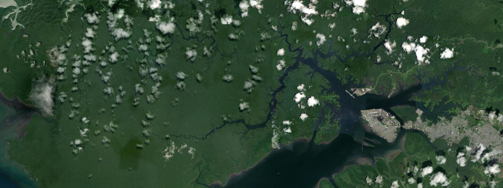
Buenaventura Bay is Colombia's main Pacific port city and the country's busiest port by cargo volume — roughly 60% of Colombia's Pacific trade moves through Buenaventura. The city occupies Cascajal Island at the inner end of the bay; the bay stretches approximately 30 km from the port to the open Pacific, funnelling through a narrows that creates the most significant tidal current on the Colombian Pacific coast.
The tidal regime at Buenaventura is macrotidal mixed semidiurnal. Spring range at Buenaventura Port is approximately 4.0–5.0 m above Chart Datum — one of the largest ranges in South America north of Patagonia. DIMAR (Dirección General Marítima) operates the official tide gauge at Buenaventura Port and publishes Colombian Pacific tide tables; Buenaventura is the primary reference station for the Colombian Pacific coast. Two highs and two lows occur per day with significant diurnal inequality; the larger daily high can exceed the smaller by 1.0–1.5 m on certain lunar phases.
The narrows between the outer and inner sections of Buenaventura Bay concentrates the tidal prism as the bay narrows from approximately 5 km width at the outer entrance to 1–2 km at the main channel through Cascajal Island. Tidal current through the narrows runs 2.0–3.0 knots at springs; commercial vessels navigate the narrows under pilotage on the most favourable tide phase. The current reversal at slack water (within 20–30 minutes of the predicted high or low) is the preferred transit window for small vessels.
The inner bay around Cascajal Island has an active mangrove fringe; the mangrove channels behind the city are a productive ecosystem for juvenile fish and a feeding area for herons, egrets, and occasional caimans. Kayaking in the inner mangrove channels is possible from Playa Piñal (the closest beach to the city centre) at high water when the channels are full; at low water the inner mangrove channels become too shallow for paddling. The Playa Piñal itself is on the bay side of Cascajal Island; the water is turbid from the river discharge and the port traffic.
Buenaventura is the departure point for the lanchas to Juanchaco and Ladrilleros on the open Pacific coast. The bay crossing from the city dock to the open coast takes 2–2.5 hours; departures are in the morning and conditions are calmer at that time. DIMAR publishes official Colombian Pacific tide tables and maritime safety information for the bay and coast. Predictions here: Open-Meteo Marine, ±45 min / ±0.2–0.3 m.
Buenaventura's city centre on Cascajal Island has been subject to significant urban renewal investment over the past decade; the Malecón del Pacífico boardwalk runs along the bay-facing north side of the island and is the primary public waterfront space. The view from the Malecón takes in the inner bay and the mangrove channels to the east; at low water the inner bay shallows and the mangrove prop-root systems are exposed. At high water the mangroves are flooded to canopy level and the tide-dependent birdlife — herons, egrets — moves from the prop roots to the higher branches.
Buenaventura's social and economic context is an important part of understanding the city's coastal character. The city has historically had high rates of violence and displacement; significant improvements in security since the mid-2010s have allowed the waterfront development and tourism infrastructure investment that has changed the Malecón and the port area. The Afro-Colombian community that makes up the majority of Buenaventura's population has deep roots in the Chocó Pacific coast; the traditional fishing and coastal livelihood practices of this community remain active alongside the modern port economy. The Pacific mangrove ecosystem around Buenaventura Bay represents one of the most extensive intact mangrove forests on the Pacific coast of South America; the tidal exchange that sustains it makes it one of the most productive nursery habitats in the Colombian Pacific.
Tide questions about Buenaventura Bay
Quick answers to the most common questions about tide times, range, and water access at Buenaventura Bay.
What is the tidal range at Buenaventura, and how does it affect the port?
Spring range at Buenaventura Port is approximately 4.0–5.0 m above Chart Datum — macrotidal. The port handles large commercial vessels on a 24-hour schedule; the port approach channel is maintained at sufficient depth for the largest vessels at all tide states. The stronger effect is felt in the inner anchorage and the smaller dock facilities, where depth at spring low tide is significantly less than at high water. DIMAR operates the official tide gauge at the port and publishes Colombian Pacific tide tables; port operations use official DIMAR data. This page is not for navigation. The port authority (Sociedad Portuaria Regional de Buenaventura) manages vessel scheduling around the tidal cycle; the main berths are on the outer, deeper channel side of Cascajal Island.
Where do the tide predictions on this page come from?
Open-Meteo Marine, a free gridded global ocean model. Accuracy is typically ±45 minutes on timing and ±0.2–0.3 m on height. DIMAR (Dirección General Marítima) operates the official tide gauge at Buenaventura Port and publishes Colombian Pacific tide tables; Buenaventura is the primary reference station for the Colombian Pacific coast. For navigation in Buenaventura Bay and port, use DIMAR data. This page is not for navigation. DIMAR's Buenaventura gauge has one of the longest continuous sea-level records on the Pacific coast of South America.
Is it safe to kayak in the Buenaventura Bay mangrove channels?
The inner mangrove channels behind Cascajal Island are accessible by kayak from Playa Piñal at high water; the channels are 0.5–2.0 m deep at high water and productive for bird observation. At low water the inner channels drain to shallow mud and are inaccessible to kayaks. The main bay channel carries commercial port traffic; kayaking in the shipping channel is prohibited and dangerous. Stay in the inner mangrove channels well clear of the commercial fairway. Afternoon wind across the bay can make the return paddle more strenuous; start in the morning. The inner mangrove channels at Playa Piñal are within the Malecón del Pacífico development zone; access by kayak requires coordination with the Malecón management.
How do I book a lancha to Juanchaco or Ladrilleros from Buenaventura?
Lanchas (motorised boats) to Juanchaco and Ladrilleros depart from the Buenaventura municipal boat dock (Muelle Turístico). Multiple operators run daily services; the earliest departures leave at 07:00–08:00 and take 2–2.5 hours. Buy tickets at the dock on the day or through accommodation in Juanchaco/Ladrilleros who can arrange pre-booking. The crossing goes through the inner bay channels and out through the bay entrance to the open Pacific coast; conditions in the outer bay and coast are rougher in the afternoon when swell and sea breeze are combined. The Muelle Turístico departs from the northern waterfront of Cascajal Island; confirm the specific dock coordinates with your lancha operator.
What is the tidal current like in Buenaventura Bay narrows?
The main channel narrows as the bay approaches Cascajal Island from the outer entrance; tidal current in the narrows runs 2.0–3.0 knots at springs. Commercial vessels navigate under pilotage on the most favourable tide phase; small vessels transit within 20–30 minutes of slack water (at or near the predicted high or low) to avoid the strongest current. The current reversal at slack is sharp — from 2+ knots to near-zero in about 15 minutes; the slack window is brief. Lanchas to the open coast transit the narrows as part of their regular crossing; the operators time their runs accordingly. The narrows between outer and inner Buenaventura Bay is the most significant tidal current hazard for recreational vessels in the Colombian Pacific; transit at slack water.
7-day tide table — Buenaventura Bay
Heights relative to MSL. Predictions: Open-Meteo Marine (MeteoFrance SMOC, 0.08° grid) — heights relative to MSL (not chart datum / LAT). Model-derived.
| Day | Type | Time | Height |
|---|---|---|---|
| Sun 21 Jun | Low | 01:48 | -0.9m |
| High | 08:06 | 1.9m | |
| Low | 14:24 | -0.6m | |
| High | 20:27 | 1.6m | |
| Mon 22 Jun | Low | 02:43 | -0.7m |
| High | 09:02 | 1.7m | |
| Low | 15:21 | -0.5m | |
| High | 21:27 | 1.4m | |
| Tue 23 Jun | Low | 03:32 | -0.5m |
| High | 10:00 | 1.6m | |
| Low | 16:19 | -0.4m | |
| High | 22:33 | 1.2m | |
| Wed 24 Jun | Low | 04:33 | -0.3m |
| High | 10:58 | 1.5m | |
| Low | 17:27 | -0.4m | |
| High | 23:42 | 1.2m | |
| Thu 25 Jun | Low | 05:39 | -0.3m |
| High | 11:55 | 1.5m | |
| Low | 18:21 | -0.4m | |
| Fri 26 Jun | High | 00:36 | 1.2m |
| Low | 06:33 | -0.3m | |
| High | 12:46 | 1.5m | |
| Low | 19:16 | -0.5m | |
| Sat 27 Jun | High | 13:32 | 1.5m |
| Low | 18:00 | -0.1m |