Xiamen tide times
Xiamen tide forecast — heights relative to MSL.
Today's tide times for Xiamen
Tide times at Xiamen on Saturday, 27 June 2026: first low tide at 08:00am, first high tide at 09:33am, second low tide at 04:04pm, second high tide at 10:43pm. Sunrise 05:21am, sunset 06:59pm.
Tide chart for Xiamen
24-hour cosine-interpolated curve around the present moment. Heights relative to MSL. Predictions: Predictions: Open-Meteo Marine (MeteoFrance SMOC, 0.08° grid).
Sun, moon and conditions on Sat 27 Jun
Snapshot at build time — refreshes daily. Sea state from Open-Meteo Marine.
Highs and lows next 7 days
Every predicted high and low for the next week, with the daily tidal coefficient (0–120; higher = bigger swing, > 95 means stronger currents).
Other spots nearby
The three closest curated TideTurtle locations to Xiamen, measured by great-circle distance.
Today's solunar windows
Solunar tradition: major periods are the ≈3h windows around moon transit and opposition; minor are ≈2h around moonrise and moonset. Pair with the local tide stage and wind for the best read.
Cycle dates near Xiamen
Next spring tide on Wed 01 Jul (range 4.2m). Last neap on Sat 27 Jun.
Spring tides cluster around new and full moons (biggest swings). Neap tides land on quarter moons (smallest swings). See the spring tide and neap tide glossary entries for the why.
About tides at Xiamen
A short guide to the coastline at Xiamen — geography, sea state, and what the tide is actually doing under your feet.
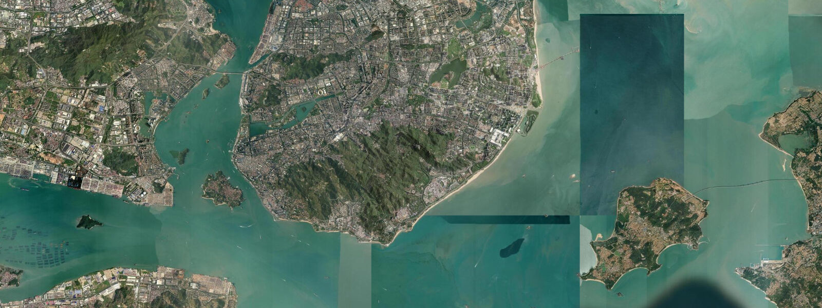
Xiamen sits on an island in southern Fujian, connected to the mainland by bridges and separated from Gulangyu Island by a tidal strait 600 m wide. Spring tidal range in Xiamen Bay is approximately 4.5 m above MLLW, and the bay's semi-enclosed geometry produces two unequal tidal cycles each day. The strait between Xiamen Island and Gulangyu runs faster on the ebb than the flood — ferry operators and kayakers both account for that asymmetry.
Gulangyu Island was designated a UNESCO World Heritage Site in 2017 for its International Settlement architecture: a dense mix of Victorian colonial buildings, Fujian vernacular structures, and early 20th-century villas built by merchants, missionaries, and consulates from a dozen countries. The island is car-free, accessed only by ferry, and the ferry crossing itself is worth timing around the tidal current. At peak ebb, the strait runs at 2–3 knots, and the ferries angle noticeably to hold their line. The small beach on Gulangyu's south side shrinks substantially on a rising spring tide — visit at low water for the full beach and exposed rock platforms.
The tidal flats between Xiamen Island's western shore and Zhangzhou on the mainland are some of the most extensive in Fujian. At low water, the flat spans several kilometres, and it is layered with oyster culture: rows of staked wooden frames carrying oyster clusters that hang below the waterline at high tide and are harvested by hand at low water. The oysters grown here are Crassostrea gigas, the Pacific oyster, and they go into local restaurants on the same day they are pulled. Walking the flats is possible during the lowest spring tides but requires rubber boots — the substrate alternates between firm sand and soft grey mud.
Hulishan Cannon Fort on Xiamen Island's southern headland dates from the Qing Dynasty and was built to command the sea approach. Two German-manufactured Krupp cannons from 1894 remain on the gun platforms, facing the tidal strait. The fort is above the tidal zone, but the coastline immediately below it is a mix of rocky reef and sandy beach exposed at low water, accessible by staircase for intertidal exploration.
The coastal ring road around Xiamen Island is a cycling and running route with consistent tidal views. The western stretch, facing the Zhangzhou tidal flats, passes several informal fishing platforms where locals use lift nets on the incoming tide. The nets are lowered on the ebb, baited, and raised when the incoming current concentrates fish over the platform. Timing the coastal ride to coincide with high water on the western side gives views of the oyster frames just submerged, with the current flowing visibly between them.
Kayaking in Xiamen Bay is well-established, and the bay's relative shelter from oceanic swell makes it accessible to intermediate paddlers. The main navigation consideration is the tidal current, which becomes significant in the strait channels on spring tides. Launching from the eastern beaches on a flood tide and returning on the ebb is a standard routing approach. The Xiamen–Kinmen (Quemoy) sea boundary sits a few kilometres to the east — kayakers must stay clear of restricted waters.
Intertidal birdwatching on the Xiamen tidal flats has a dedicated following. The bay is on the East Asian–Australasian Flyway, and the western mud flats attract significant numbers of spoon-billed sandpiper, black-faced spoonbill, and other threatened species during spring and autumn migration. The black-faced spoonbill roosts on the oyster frames at high tide.
For photographers and naturalists, the combination of a working tidal culture — oyster farms, ferry crossings, fishing lift-nets — and significant migratory birdlife makes Xiamen Bay one of the most productive intertidal destinations on the Fujian coast. Tidal predictions here use the Open-Meteo Marine gridded model (±45 minutes on timing, ±0.3 m on height). Not for navigation.
Tide questions about Xiamen
Quick answers to the most common questions about tide times, range, and water access at Xiamen.
What is the tidal range in Xiamen Bay?
Spring tidal range in Xiamen Bay is approximately 4.5 m above MLLW (Mean Lower Low Water). The bay experiences semidiurnal tides with diurnal inequality — two highs and two lows each day, but of unequal heights. Neap tides reduce the range to roughly 1.5–2 m. The tidal strait between Xiamen Island and Gulangyu Island experiences noticeable currents on spring tides, particularly on the ebb. Boaters and kayakers should account for a 2–3 knot current through the strait at peak ebb on spring tides.
When is the best time to visit the tidal flats for birdwatching in Xiamen?
April–May and September–October are the migration windows on the East Asian–Australasian Flyway. The western Xiamen tidal flats host threatened species including spoon-billed sandpiper and black-faced spoonbill — the latter roosts on oyster frames and rocky islets as the tide rises. The 2–3 hours around low water expose the greatest area of feeding habitat. Birds concentrate on the mid-flat at low water and retreat to roost on elevated structures at high tide. The Xiamen Egret Nature Reserve on the northern part of the island provides formal birdwatching access with viewing platforms overlooking the flat.
How does the ferry to Gulangyu Island interact with the tidal current?
The public ferry crossing from Xiamen Island to Gulangyu runs approximately 600 m across a tidal strait. On spring ebb tides, the current runs at 2–3 knots, and ferries visibly angle into the current to maintain a straight track across the strait. Crossing time varies by about 2–3 minutes between slack and peak-current conditions. The tourist ferry operates a separate route and berths on the island's eastern side. Neither ferry is dangerous in normal conditions, but kayakers and paddleboarders crossing the strait should time their crossing around slack water.
Can I walk on the Xiamen oyster flats at low tide?
The tidal flats between Xiamen Island's western shore and the Zhangzhou coast are accessible on foot during the lowest spring tides, but public access is informal and the substrate is not uniformly firm. Rubber boots are essential — the flat alternates between compact sand and deep soft mud, and sections around active oyster culture areas are often deliberately avoided by casual walkers. The oyster frames are working aquaculture infrastructure; do not disturb the stock or equipment. The most accessible section for flat walking is south of Haicang Bridge, where the flat is firmer and the tide drains more predictably.
What is Gulangyu Island and why is it a UNESCO World Heritage Site?
Gulangyu is a small, car-free island in Xiamen Bay designated a UNESCO World Heritage Cultural Landscape in 2017. Its significance lies in the physical record of its International Settlement period (1903–1941), when it hosted consulates and residences from 13 countries alongside Fujian merchant families. The result is a dense architectural mix — Victorian colonial, Baroque, Art Deco, and Fujian vernacular styles — largely intact and still inhabited. The island is also known as Piano Island from the concentration of piano schools established during the settlement era. Access is by ferry from Xiamen only.
8-day tide table — Xiamen
Heights relative to MSL. Predictions: Open-Meteo Marine (MeteoFrance SMOC, 0.08° grid) — heights relative to MSL (not chart datum / LAT). Model-derived.
| Day | Type | Time | Height |
|---|---|---|---|
| Sat 27 Jun | Low | 08:00 | 1.4m |
| High | 09:33 | 1.8m | |
| Low | 16:04 | -1.4m | |
| High | 22:43 | 2.0m | |
| Sun 28 Jun | Low | 04:32 | -0.4m |
| High | 10:14 | 1.8m | |
| Low | 16:50 | -1.7m | |
| High | 23:21 | 2.1m | |
| Mon 29 Jun | Low | 05:17 | -0.6m |
| High | 10:56 | 1.8m | |
| Low | 17:28 | -1.8m | |
| Tue 30 Jun | High | 00:00 | 2.1m |
| Low | 05:55 | -0.6m | |
| High | 11:32 | 1.9m | |
| Low | 18:03 | -2.0m | |
| Wed 01 Jul | High | 00:34 | 2.1m |
| Low | 06:27 | -0.7m | |
| High | 12:08 | 2.0m | |
| Low | 18:38 | -2.0m | |
| Thu 02 Jul | High | 01:07 | 2.2m |
| Low | 07:00 | -0.7m | |
| High | 12:43 | 2.0m | |
| Low | 19:10 | -2.0m | |
| Fri 03 Jul | High | 01:41 | 2.2m |
| Low | 07:32 | -0.8m | |
| High | 13:20 | 2.0m | |
| Low | 19:43 | -2.0m | |
| Sat 04 Jul | High | 02:14 | 2.2m |
| Low | 07:00 | -0.6m |