Praia tide times
Praia tide forecast — heights relative to MSL.
Today's tide times for Praia
Tide times at Praia on Saturday, 27 June 2026: first high tide at 05:45pm, first low tide at 11:43pm. Sunrise 06:06am, sunset 07:07pm.
Tide chart for Praia
24-hour cosine-interpolated curve around the present moment. Heights relative to MSL. Predictions: Predictions: Open-Meteo Marine (MeteoFrance SMOC, 0.08° grid).
Sun, moon and conditions on Sat 27 Jun
Snapshot at build time — refreshes daily. Sea state from Open-Meteo Marine.
Highs and lows next 7 days
Every predicted high and low for the next week, with the daily tidal coefficient (0–120; higher = bigger swing, > 95 means stronger currents).
Other spots nearby
The three closest curated TideTurtle locations to Praia, measured by great-circle distance.
Today's solunar windows
Solunar tradition: major periods are the ≈3h windows around moon transit and opposition; minor are ≈2h around moonrise and moonset. Pair with the local tide stage and wind for the best read.
Cycle dates near Praia
Next spring tide on Thu 02 Jul (range 0.9m). Next neap on Mon 29 Jun.
Spring tides cluster around new and full moons (biggest swings). Neap tides land on quarter moons (smallest swings). See the spring tide and neap tide glossary entries for the why.
About tides at Praia
A short guide to the coastline at Praia — geography, sea state, and what the tide is actually doing under your feet.
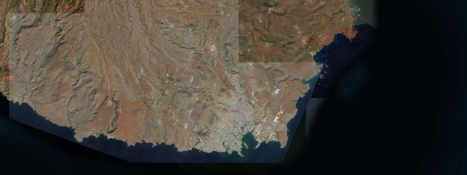
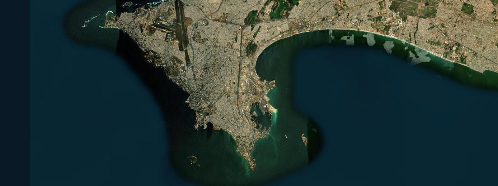
Praia is the capital and largest city of Cape Verde, built on the southern coast of Santiago island — the largest island in the archipelago and, uniquely, the one with enough agricultural land to sustain a substantial population without the food imports the other islands depend on. The city occupies a dramatic site: the historic Plateau district (Platô) sits 60 m above the Atlantic on a flat-topped mesa, its cliff edges dropping directly to the rocky shoreline below, with the working port and Prainha beach wedged between the base of the plateau and the sea.
The tidal regime at Praia is fully Atlantic, mixed semidiurnal, with a spring range of approximately 2.3 m — the largest of the three Cape Verde places covered here, reflecting Santiago's more southerly position and the local bathymetry. The difference between a spring high and a spring low water here is significant: beaches that read as narrow strips at high tide open to wide, flat expanses at low water. Prainha, the main accessible beach in the city, nearly doubles in usable width between high and low water on spring tides.
For inter-island ferry connections, Praia is the main southern hub. The ferry terminal at the port handles connections to Fogo (1.5 hours, the active volcano island visible from Praia on clear days), Brava, Maio, and the occasional run to São Vicente in the Barlavento group. The port also handles the bulk cargo and fuel vessels that supply the Sotavento islands. Departure times are set by the ferry operator rather than by tidal state — the approaches are deep enough that a 2.3 m range does not restrict port entry.
The Plateau district is the city's historic, administrative, and commercial core. The Sucupira market, on the lower edge of the Platô, is Cape Verde's largest market: electronics, clothing, household goods, and food stalls spread across several city blocks in partly covered arcade, partly open air. The adjacent produce section carries the full range of Santiago's agricultural output — papaya, mango, plantain, cassava, and the grogue (sugar cane spirit) that is Santiago's most noted product. The views from the Plateau cliff edge — north to the island interior, south over the Atlantic toward Fogo — are the standard orientation point for first-time visitors.
For paddlers, the bay south of the port has relatively sheltered water inside the breakwater. The tidal range of 2.3 m on springs means that the intertidal zone on the rocky shoreline below the Plateau cliffs covers and uncovers a vertical 2.3 m of volcanic rock — at spring low water, extensive rocky shelves are exposed along the cliff base, accessible on foot from Prainha beach for approximately 400 m east. These shelves hold sea urchins, octopus, and small reef fish in the pools.
The Harmattan arrives December through March from the Saharan interior. At 14.9°N, Praia is closer to the source than Mindelo — visibility drops to 2–3 km in the worst events, and the dust requires wiping camera lenses repeatedly. The south coast of Santiago sits slightly away from the main NE trade wind axis, providing a degree of shelter; the north coast, directly exposed, is rougher and less developed.
Anglers working the Praia waterfront use the rocky points and the breakwater structures at the port entrance. The ebb tide concentrates amberjack, barracuda, and various snapper species at the breakwater tip as current drains over the rocky bottom east of the port. Offshore, Santiago sits in productive Cape Verde bluefin tuna and marlin territory — the deep Atlantic channel between Santiago and Fogo, 60 km wide, is among the best big-game fishing waters in the archipelago. Charter boats operate from the port for half-day and full-day offshore sessions.
Photographers at Praia work two compositions: the Plateau cliffs from beach level at low tide, where the full 60 m mesa edge is visible with traditional houses on top; and the wide Prainha beach at spring low water, volcanic sand extending to the watermark with the plateau as backdrop. Families find Prainha practical — the gently shelving bottom is safe for wading, and the 2.3 m spring range produces calmer run-up at low water when waves reach flat wet sand rather than the steeper upper beach. Water temperature stays 22–25°C year-round.
All tide predictions for Praia come from the Open-Meteo Marine gridded model. Timing accuracy is ±45 minutes; height accuracy is ±0.3 m above Chart Datum.
Tide questions about Praia
Quick answers to the most common questions about tide times, range, and water access at Praia.
What is the tidal range at Praia and how does it affect the beach?
Praia has a spring tidal range of approximately 2.3 m, the largest in the Cape Verde Islands. Prainha beach nearly doubles in usable width between high water and low water on spring tides. At spring low water, volcanic rock shelves east of the beach are exposed for 400 m along the cliff base, accessible on foot. Neap range drops to roughly 1.0 m. The consistent swell run-up on the beach is gentler at low water when waves break on the flat sandy section rather than the steeper upper beach.
What inter-island ferry connections run from Praia?
Praia is the main southern ferry hub for Cape Verde. Regular services run to Fogo (approximately 1.5 hours), Brava, and Maio. Less frequent connections go to the Barlavento islands including São Vicente. The ferry terminal is at the port below the Plateau district. Schedules shift seasonally and are affected by weather during the heavy trade-wind period (November–April) — check current timetables with ISCV (Cabo Verde Fast Ferry) on arrival. Fogo's volcanic cone is visible from Praia on clear days, providing a visual reference for the crossing direction.
What is grogue and where can I find it in Praia?
Grogue is Cape Verde's traditional sugarcane spirit, distilled in small-batch alembic stills on Santiago island (and, to a lesser extent, on Santo Antão). The spirit is unaged and clear, typically 40–50% ABV, with a raw, agricole-style character that reflects the island's volcanic soil. Aged versions (pontche, with honey and lemon) are also produced. The Sucupira market on the Plateau carries grogue from multiple distillers; the interior agricultural valleys of Santiago — accessible by taxi for a half-day excursion — have working distilleries where production can be observed during the harvest season (roughly July through October).
Is the Harmattan worse in Praia than in Mindelo?
Praia sits at 14.9°N, roughly 200 km south of Mindelo, closer to the Saharan Harmattan source. The dust events can be more concentrated in Praia, with visibility dropping to 2–3 km in the heaviest events between December and March. The Harmattan affects the south coast of Santiago, where Praia sits, and can last 3–7 days per event. It does not significantly affect sea conditions or ferry operations, but it substantially changes light quality for photography and can cause respiratory irritation for sensitive individuals during peak events.
Where do anglers fish in Praia?
Shore anglers work the port breakwater and the rocky points east of Prainha beach on the ebb tide, targeting amberjack, barracuda, and snapper that congregate where the current drains over the rocky bottom. The extensive intertidal volcanic shelves exposed at low water hold octopus accessible to free divers. Offshore, the deep channel between Santiago and Fogo is well-regarded Cape Verde bluefin tuna and blue marlin territory. Charter boats operate from the main port; bookings are made through the marina office or direct contact with local operators who moor at the commercial quay.
7-day tide table — Praia
Heights relative to MSL. Predictions: Open-Meteo Marine (MeteoFrance SMOC, 0.08° grid) — heights relative to MSL (not chart datum / LAT). Model-derived.
| Day | Type | Time | Height |
|---|---|---|---|
| Sat 27 Jun | High | 17:45 | 0.1m |
| Low | 23:43 | -0.5m | |
| Sun 28 Jun | High | 06:10 | 0.2m |
| Low | 12:18 | -0.5m | |
| Mon 29 Jun | High | 06:48 | 0.3m |
| Low | 13:00 | -0.5m | |
| High | 19:03 | 0.2m | |
| Tue 30 Jun | Low | 00:57 | -0.5m |
| High | 19:36 | 0.2m | |
| Wed 01 Jul | Low | 01:35 | -0.6m |
| High | 08:02 | 0.4m | |
| Low | 14:15 | -0.5m | |
| High | 20:15 | 0.2m | |
| Thu 02 Jul | Low | 02:10 | -0.6m |
| High | 08:36 | 0.4m | |
| Low | 14:55 | -0.5m | |
| High | 20:50 | 0.2m | |
| Fri 03 Jul | Low | 02:46 | -0.5m |
| High | 09:13 | 0.4m |