Silver Sands tide times
Silver Sands tide forecast — heights relative to MSL.
Today's tide times for Silver Sands
Tide times at Silver Sands on Saturday, 4 July 2026: first high tide at 05:18am, first low tide at 11:50am, second high tide at 06:20pm. Sunrise 05:36am, sunset 06:28pm.
Tide chart for Silver Sands
24-hour cosine-interpolated curve around the present moment. Heights relative to MSL. Predictions: Predictions: Open-Meteo Marine (MeteoFrance SMOC, 0.08° grid).
Sun, moon and conditions on Sat 04 Jul
Snapshot at build time — refreshes daily. Sea state from Open-Meteo Marine.
Highs and lows next 7 days
Every predicted high and low for the next week, with the daily tidal coefficient (0–120; higher = bigger swing, > 95 means stronger currents).
Other spots nearby
The three closest curated TideTurtle locations to Silver Sands, measured by great-circle distance.
Today's solunar windows
Solunar tradition: major periods are the ≈3h windows around moon transit and opposition; minor are ≈2h around moonrise and moonset. Pair with the local tide stage and wind for the best read.
Cycle dates near Silver Sands
Last spring tide on Fri 03 Jul (range 0.6m). Next spring tide on Thu 09 Jul (range 0.6m). Next neap on Mon 06 Jul.
Spring tides cluster around new and full moons (biggest swings). Neap tides land on quarter moons (smallest swings). See the spring tide and neap tide glossary entries for the why.
About tides at Silver Sands
A short guide to the coastline at Silver Sands — geography, sea state, and what the tide is actually doing under your feet.
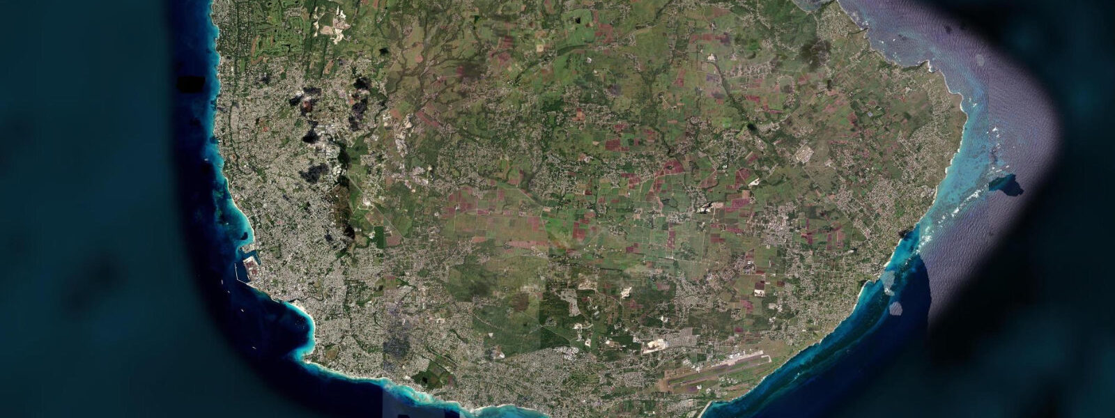
Silver Sands sits at the southern tip of Barbados in Christ Church parish, adjacent to South Point and the lighthouse that marks the island's southernmost extent. The beach is technically on the Caribbean side of the island but close enough to the South Point headland that the trade winds, accelerating around the tip of the land, hit the bay at consistent and elevated speed. Wind readings of 15 to 25 knots from the east-northeast are the norm from December through May; the summer months from June through October see lighter but still consistent winds from the southeast.
7 metres — makes Silver Sands the regional capital of kitesurfing and windsurfing in Barbados and one of the recognised kite destinations in the eastern Caribbean. The Silver Sands resort area includes several kite schools and rental operations; the beach is the place in Barbados to learn kitesurfing, and the intermediate to advanced riders can be watched working the flat-water sections inside the reef or jumping in the chop outside. The South Point reef itself is a reef structure that breaks the swell before it reaches the lagoon, creating the flat-water conditions preferred for kite riding.
The reef is also a dive site — accessible by boat from Oistins or Bridgetown — with a mix of staghorn coral, sea fans, and the invertebrate communities that inhabit the rubble zones. South Point Lighthouse, built in the 1850s, stands on the headland above the beach and is now automated but still operational. The lighthouse grounds are accessible; the view from the headland takes in both the Atlantic to the east and the Caribbean to the west on the same horizon, with the transition visible in sea state.
The beach at Silver Sands is one of the widest and least developed on the south coast; the same winds that make it ideal for kite sports make it uncomfortable for beach relaxing without a windbreak. Families with children and non-kiting sun-seekers tend to prefer the more sheltered beaches east of Oistins at Miami Beach or at Inch Marlow. The Silver Sands area has a mix of self-catering villas (popular with kitesurfers staying a week or more) and the larger Silver Sands Resort hotel.
The residential neighbourhood behind the beach is quiet. Predictions on this page come from Open-Meteo Marine, a gridded global ocean model. 3 metres on height — model-derived, not from a local gauge.
The Caribbean Institute of Meteorology and Hydrology (CIMH) is the regional hydrometeorological reference authority for Barbados.
Tide questions about Silver Sands
Quick answers to the most common questions about tide times, range, and water access at Silver Sands.
Why is Silver Sands good for kitesurfing?
Three factors combine. First, the trade winds accelerate around South Point headland and produce reliable 15 to 25 knot speeds from December through May — consistent enough that kite schools can operate year-round with high confidence in conditions. Second, the South Point reef breaks the Atlantic swell before it reaches the lagoon, creating flat water suitable for beginners learning to ride without fighting waves. Third, the small Caribbean tidal range (0.5 to 0.7 metres spring) means the flat-water lagoon is consistently usable across the full tidal cycle without the conditions changing significantly between high and low water.
Can beginners learn to kitesurf at Silver Sands?
Yes — Silver Sands is one of the better places in the eastern Caribbean to learn. Several licensed kite schools operate on the beach with certified IKO instructors. The learning progression starts with ground training on the beach, then body dragging in the flat-water lagoon, then board start. The flat-water conditions inside the reef keep the learning environment manageable. A full beginner course runs 6 to 9 hours over 3 days. Book in advance in January and February when the beach is at peak capacity. The minimum age for lessons is typically 14; the minimum physical requirement is the ability to swim 200 metres.
What else is at Silver Sands besides kitesurfing?
The South Point Lighthouse headland is a 10-minute walk and provides one of the best views on the island — Atlantic on one side, Caribbean on the other. Oistins Fish Fry, 3 kilometres east, is the most famous Friday night event in Barbados. Miami Beach (Silver Rock Beach), 2 kilometres east along the south coast road, is a calmer beach suitable for swimming. Snorkelling in the shallower sections of the South Point reef can be reached by swimming from the southern end of the beach. The residential neighbourhood behind Silver Sands is quiet and the self-catering villas there are popular with surfers and kite riders who want to stay a week.
What is the tidal range at Silver Sands?
Silver Sands is on the Caribbean-facing south coast of Barbados. Spring tidal range is approximately 0.5 to 0.7 metres — microtidal by global standards. The dominant influences on water level are wind-driven Caribbean swell and the small astronomical tide. The flat-water lagoon inside the South Point reef is usable at all states of tide; the lagoon depth changes by less than a metre between high and low water at spring tides, and the difference between spring and neap conditions is small enough to be irrelevant for water sports planning.
Is Silver Sands suitable for swimming?
The lagoon inside the reef at Silver Sands is shallow and calm enough to swim in when the kite traffic is low — early morning before the kite schools open is the best window. At any other time of day in the trade wind season, the beach is active with kite traffic and the downwind zones in the water need to be treated as hazardous. Non-kiting swimmers should use the adjacent Miami Beach (Silver Rock) 2 kilometres east, which has a calmer beach and no kite traffic. The open water outside the South Point reef is exposed to ocean swell and tidal stream and should not be treated as a swimming beach.
7-day tide table — Silver Sands
Heights relative to MSL. Predictions: Open-Meteo Marine (MeteoFrance SMOC, 0.08° grid) — heights relative to MSL (not chart datum / LAT). Model-derived.
| Day | Type | Time | Height |
|---|---|---|---|
| Sat 04 Jul | High | 05:18 | 0.5m |
| Low | 11:50 | -0.1m | |
| High | 18:20 | 0.5m | |
| Sun 05 Jul | Low | 00:00 | 0.1m |
| High | 05:55 | 0.5m | |
| Low | 12:21 | -0.0m | |
| High | 18:54 | 0.5m | |
| Mon 06 Jul | Low | 00:54 | 0.1m |
| High | 06:45 | 0.4m | |
| Low | 13:10 | 0.0m | |
| Tue 07 Jul | High | 07:54 | 0.4m |
| Low | 14:00 | 0.1m | |
| High | 20:18 | 0.5m | |
| Wed 08 Jul | Low | 03:15 | 0.0m |
| High | 09:15 | 0.3m | |
| Low | 14:50 | 0.1m | |
| High | 21:18 | 0.5m | |
| Thu 09 Jul | Low | 04:18 | -0.0m |
| High | 22:18 | 0.5m | |
| Fri 10 Jul | Low | 05:42 | -0.1m |
| High | 19:00 | 0.2m |