Al Muharraq tide times
Al Muharraq tide forecast — heights relative to MSL.
Today's tide times for Al Muharraq
Tide times at Al Muharraq on Saturday, 4 July 2026: first low tide at 03:00am, first high tide at 07:39am, second low tide at 01:25pm, second high tide at 07:17pm. Sunrise 04:49am, sunset 06:34pm.
Tide chart for Al Muharraq
24-hour cosine-interpolated curve around the present moment. Heights relative to MSL. Predictions: Predictions: Open-Meteo Marine (MeteoFrance SMOC, 0.08° grid).
Sun, moon and conditions on Sat 04 Jul
Snapshot at build time — refreshes daily. Sea state from Open-Meteo Marine.
Highs and lows next 7 days
Every predicted high and low for the next week, with the daily tidal coefficient (0–120; higher = bigger swing, > 95 means stronger currents).
Other spots nearby
The three closest curated TideTurtle locations to Al Muharraq, measured by great-circle distance.

Today's solunar windows
Solunar tradition: major periods are the ≈3h windows around moon transit and opposition; minor are ≈2h around moonrise and moonset. Pair with the local tide stage and wind for the best read.
Cycle dates near Al Muharraq
Last spring tide on Sat 04 Jul (range 1.5m). Next neap on Mon 06 Jul.
Spring tides cluster around new and full moons (biggest swings). Neap tides land on quarter moons (smallest swings). See the spring tide and neap tide glossary entries for the why.
About tides at Al Muharraq
A short guide to the coastline at Al Muharraq — geography, sea state, and what the tide is actually doing under your feet.
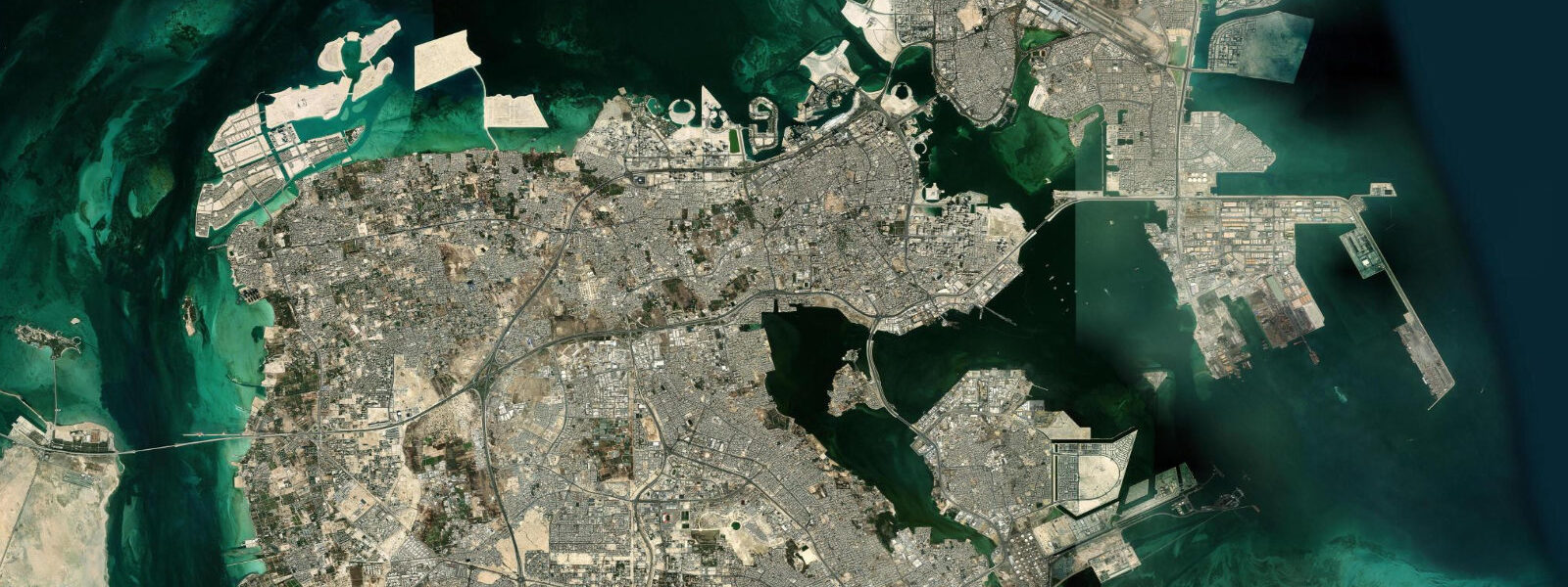
Al Muharraq is Bahrain's second city and the historic heart of the Gulf's pearl-diving culture. Until the early 20th century, it was the more important of the two main islands in Bahrain — larger, closer to the pearl banks, and the seat of the Al Khalifa ruling family before the administrative focus shifted to Manama on the main island. The Pearl Road — a UNESCO World Heritage route through the old city — connects the historic merchant houses, diving equipment stores, and waterfront areas that defined the pearl trade's physical infrastructure.
Muharraq is connected to Bahrain's main island by the King Fahd Causeway (the newer bridge) and the older Muharraq Causeway. The coastal approach to Muharraq from the north takes in the view of the traditional dhow-building yard at Arad — one of the few remaining active dhow construction operations in the Gulf.
Tide predictions for Al Muharraq come from Open-Meteo Marine's global model. Timing accuracy ±45 minutes, height accuracy ±0.2 to 0.3 metres. The Gulf at Muharraq exhibits the characteristic mixed semidiurnal pattern with significant diurnal inequality; spring range runs approximately 1.5 to 2.5 metres. The tidal flat around the northern and eastern shores of Muharraq Island is extensive — at low spring tide the flat can extend 200 to 400 metres from the shoreline, exposing the muddy Gulf bottom. This flat was the working environment of the pearl divers: boats anchored on the flat at low water while divers worked the oyster beds below.
The pearl diving season ran from June through September — the hottest months, with water temperatures above 30°C. Divers made multiple breath-hold dives per day to 10 to 20 metres, collected pearl oysters (Pinctada radiata) by hand, and surfaced to be hauled up by ropes. The industry was the economic foundation of the Gulf coast from Kuwait to Oman. Japanese cultured pearls, commercially available from the mid-1920s, made the natural Gulf pearl trade uneconomical within a decade; by the mid-1930s it had effectively collapsed.
The Pearl Road heritage route covers approximately 3.5 kilometres through the old city of Muharraq. Key stops include the restored Sh. Isa bin Ali House (the residence of the late 19th-century ruler), traditional coffeehouse architecture, and the waterfront Bu Maher Fort, which dates to the early 19th century and overlooks the pearl diving anchorage. The route is walkable; the best time is early morning or after 16:00 to avoid midday heat.
For water users, the coast around Muharraq has the tidal flat character typical of the shallow Gulf. Swimming off the northeastern shore at mid-tide and above provides 1.5 to 2.0 metres of depth over the flat; at low spring tide much of the near-shore area is less than 0.5 metres deep. Bahrain International Airport is immediately adjacent to Muharraq's western shore.
The Bu Maher Fort at the northwestern tip of Muharraq faces the sea and the Manama skyline simultaneously. Built in the early 19th century to defend the pearl-diving anchorage from naval attack, it is the maritime bookend of the Pearl Road heritage trail. The restored fort structure has information panels on the pearl trade and the military context of the coastal defences. Standing at the fort's seaward wall with the view of Manama's contemporary skyline across the water — glass towers and hotels built on land reclaimed from the same Gulf that the fort defended — provides a compressed version of Bahrain's 200-year economic transformation.
The Al Muharraq souk and old merchant quarter, behind the waterfront, retains more intact traditional architecture than most of the Gulf region. The narrow wind-tower houses — built with barjeel towers to funnel sea breeze into the interior — are the functional predecessors of air conditioning. Several are open to the public as part of the Pearl Road heritage circuit; the Sh. Isa bin Ali House is the most complete restoration and gives a full picture of the spatial organisation of a wealthy pearl-merchant household.
For tidal biology at Muharraq's northern flat, the spring low-tide exposure creates a rich intertidal zone. The exposed mud and sand support ghost crabs, fiddler crabs, and the mudskipper (Boleophthalmus), an amphibious fish that moves across the tidal flat surface using modified pectoral fins. Flamingos feed on the exposed flat from October through April, and the heron-egret community is active year-round at the tideline.
Tide questions about Al Muharraq
Quick answers to the most common questions about tide times, range, and water access at Al Muharraq.
What is the tidal range at Al Muharraq?
Al Muharraq is on the northeast coast of Bahrain in the shallow Persian Gulf. Mixed semidiurnal tides with significant diurnal inequality; spring range approximately 1.5 to 2.5 metres. The extensive tidal flat around Muharraq's northern and eastern shores means the low spring tide exposes 200 to 400 metres of seabed. Tide predictions use Open-Meteo Marine's global model, with ±45 minutes timing accuracy and ±0.2 to 0.3 metres height accuracy. Shamal wind events can add 0.5 to 0.8 metres of surge to the tidal prediction on the exposed northern Gulf coast.
What is the Pearl Road UNESCO World Heritage route?
The Pearl Road (Al-Qaysariyya Souq and surrounding area) is a UNESCO World Heritage Site inscribed in 2012 under the designation 'Pearling, Testimony of an Island Economy'. The 3.5-kilometre route through old Muharraq connects the merchant and pearl merchant houses, the waterfront anchorage, storehouses for pearl-diving equipment, and religious buildings associated with the trade. The route represents the complete built environment of a Gulf pearling town as it existed before the industry's collapse. Key buildings are restored and accessible; the route is waymarked. The full walk takes 2 to 3 hours. Start at the Bu Maher Fort waterfront.
Can I see dhow building at Muharraq?
The Arad dhow-building yard, on the southern approach to Muharraq near the Arad fort, is one of the few remaining active traditional boat construction operations in Bahrain. The yard builds and repairs traditional wooden boats using methods that have changed little over centuries. It is not a formal tourist attraction but visitors can observe the work from the road. The best observation is in the morning when the workers are active. The boats built and maintained here include traditional Gulf fishing dhows and the larger baggalas and sambooqs; the variety on the yard at any one time depends on the season and current orders.
How did pearl diving work in the Gulf?
Gulf pearl diving operated on a share system coordinated by the boat captain (nakhouda). Divers wore nose clips (fatam) and descended to 10 to 20 metres on a weighted line, spending 60 to 90 seconds on the bottom collecting oysters before being hauled up by a tender on the surface. A skilled diver made 50 to 60 dives per day. Boats anchored on the pearl banks for weeks at a time; food was minimal and conditions harsh. Divers were frequently in debt to the nakhouda for advance wages; the debt-bondage element of the system was a persistent social issue. The season ran June through September, during the hottest months of the Gulf summer.
How do I get to Al Muharraq from Manama?
Al Muharraq is connected to Manama by two causeways — the main Muharraq Causeway (Sheikh Khalifa Bin Salman Highway) and the newer King Fahd road link. The drive takes 10 to 15 minutes from central Manama. Bahrain International Airport, located on the western shore of Muharraq Island, is the entry point for most international visitors — which means arriving travellers are already on Muharraq before reaching Manama. The old city Pearl Road starting point at Bu Maher Fort is on the northern waterfront; GPS navigation is the reliable approach to the trailhead.
8-day tide table — Al Muharraq
Heights relative to MSL. Predictions: Open-Meteo Marine (MeteoFrance SMOC, 0.08° grid) — heights relative to MSL (not chart datum / LAT). Model-derived.
| Day | Type | Time | Height |
|---|---|---|---|
| Sat 04 Jul | Low | 03:00 | -0.2m |
| High | 07:39 | 1.0m | |
| Low | 13:25 | 0.1m | |
| High | 19:17 | 1.1m | |
| Sun 05 Jul | Low | 01:51 | -0.3m |
| High | 08:11 | 1.0m | |
| Low | 14:05 | -0.0m | |
| High | 20:00 | 1.0m | |
| Mon 06 Jul | Low | 02:34 | -0.4m |
| High | 08:54 | 0.9m | |
| Low | 14:50 | -0.1m | |
| High | 20:46 | 0.9m | |
| Tue 07 Jul | Low | 03:06 | -0.4m |
| High | 09:34 | 0.9m | |
| Wed 08 Jul | Low | 03:50 | -0.3m |
| High | 10:16 | 0.9m | |
| Low | 16:36 | -0.2m | |
| High | 22:42 | 0.8m | |
| Thu 09 Jul | Low | 04:46 | -0.2m |
| High | 11:07 | 0.9m | |
| Low | 17:36 | -0.2m | |
| High | 23:48 | 0.8m | |
| Fri 10 Jul | Low | 05:54 | -0.1m |
| High | 12:06 | 0.8m | |
| Low | 18:50 | -0.4m | |
| Sat 11 Jul | High | 01:10 | 0.7m |