
Manama tide times
Manama tide forecast — heights relative to MSL.
Today's tide times for Manama
Tide times at Manama on Friday, 3 July 2026: first low tide at 04:06am, first high tide at 12:45pm, second low tide at 03:54pm, second high tide at 07:54pm. Sunrise 04:49am, sunset 06:34pm.
Tide chart for Manama
24-hour cosine-interpolated curve around the present moment. Heights relative to MSL. Predictions: Predictions: Open-Meteo Marine (MeteoFrance SMOC, 0.08° grid).
Sun, moon and conditions on Fri 03 Jul
Snapshot at build time — refreshes daily. Sea state from Open-Meteo Marine.
Highs and lows next 7 days
Every predicted high and low for the next week, with the daily tidal coefficient (0–120; higher = bigger swing, > 95 means stronger currents).
Other spots nearby
The three closest curated TideTurtle locations to Manama, measured by great-circle distance.
Today's solunar windows
Solunar tradition: major periods are the ≈3h windows around moon transit and opposition; minor are ≈2h around moonrise and moonset. Pair with the local tide stage and wind for the best read.
Cycle dates near Manama
Last spring tide on Fri 03 Jul (range 0.7m). Next neap on Sat 04 Jul.
Spring tides cluster around new and full moons (biggest swings). Neap tides land on quarter moons (smallest swings). See the spring tide and neap tide glossary entries for the why.
About tides at Manama
A short guide to the coastline at Manama — geography, sea state, and what the tide is actually doing under your feet.
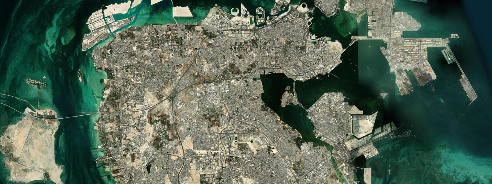
Manama sits on the northern tip of Bahrain Island, looking across the shallow waters of the Persian Gulf toward the Saudi Arabian coast, to which it has been connected by the 25-kilometre King Fahd Causeway since 1986. The city is low and flat — the highest natural point on Bahrain Island is barely 122 metres, and much of the northern coastline where Manama spreads has been reclaimed from the sea. The tidal flats that once extended broadly north of the city have been mostly displaced by reclamation, but significant flat areas remain south and east, and they are ecologically productive.
The Persian Gulf tidal regime at Manama is mixed semidiurnal. Spring tides produce a range of approximately 1.5 to 2.5 metres — among the larger ranges in the Gulf, the result of the Gulf's own resonant response to the Indian Ocean tidal forcing. The two daily tides are unequal in height; on some days the difference between the two highs reaches 0.5 to 0.8 metres. At low spring water, the tidal flats south of Manama expose for several hundred metres, and this exposure drives significant flamingo feeding activity.
Greater flamingo winter on the Bahrain tidal flats in numbers that reach 1,500 to 3,000 birds in peak years. The flats southeast of Manama, around Tubli Bay, are the main concentration area. The flamingos feed on the invertebrates and algal matter exposed at low tide; the best viewing window is the two hours either side of low water on a falling spring tide, when the birds are most actively feeding in the shallows. The Tubli Bay area is accessible by car; the birds are typically visible from the road embankments without requiring any specialist access.
Qal'at al-Bahrain — the Bahrain Fort — sits 5 kilometres west of central Manama on the northern coast. The site is UNESCO World Heritage, listed for its significance as the ancient capital of Dilmun, a civilisation that traded with Mesopotamia from the 3rd millennium BC. The fort itself is a later Portuguese construction (16th century) built over layered occupation going back 4,500 years. The museum at the site is well-curated and the fort's position on a low rise above the Gulf allows a view over the tidal flat and anchorage that gives a sense of why this site was strategically held for so long.
The Pearl Monument — a roundabout landmark in the centre of Manama — references Bahrain's pearl diving heritage. The original Pearl Roundabout was a different structure and was demolished in 2011; the current Pearl Monument on the Financial Harbour waterfront is a replacement, but the icon it references is genuine: Bahrain was the centre of the global natural pearl trade for millennia, and the collapse of the industry in the 1930s when the Japanese cultured pearl market displaced natural pearls was an economic shock the country spent decades recovering from.
The Suq al-Qaysariyya, the traditional covered market, operates near the old town area. Gold, spices, fabrics, and electronics share space in the lanes. The gold market is substantial — Bahrain has historically been a trading centre and the gold suq reflects that.
The Bahrain World Trade Center on the King Faisal Highway is a pair of sail-shaped towers with three horizontal wind turbines spanning between them at floors 29, 36, and 43. The turbines are functional, not decorative. On the waterfront below, the Corniche promenade runs along the northern coast — a popular walking route in the cooler months (November through March) when temperatures drop to 15-22°C.
For anglers, the tidal flats and breakwaters around the northern coast produce rabbitfish, bream, and occasional Spanish mackerel. The outgoing tide concentrates fish against structure; the last two hours of the ebb are typically most productive.
The northern Manama waterfront has undergone successive reclamation projects — the Financial Harbour development, the Reef Island project, and various marina expansions have pushed the coastline north by hundreds of metres in some sections. The original shoreline of Manama is now well inland of the current waterfront. The Corniche promenade that runs along the northern shore is built on this reclaimed land, and the tidal flats that historically spread broadly north of the city have been substantially reduced by the accumulated reclamation. The remaining productive tidal flats are concentrated to the south and east, particularly around Tubli Bay, where the flamingo concentrations reflect the ecological value of what has not yet been reclaimed.
Predictions on this page come from Open-Meteo Marine, a gridded global ocean model. Accuracy is typically within plus or minus 45 minutes on timing and 0.2 to 0.3 metres on height — model-derived, not from a local gauge. The authoritative source for tidal data in Bahrain is the Bahrain Meteorological Service.
Tide questions about Manama
Quick answers to the most common questions about tide times, range, and water access at Manama.
What is the tidal range at Manama?
Manama experiences one of the larger tidal ranges in the Persian Gulf — spring tides produce approximately 1.5 to 2.5 metres between high and low water. The regime is mixed semidiurnal, meaning two tide cycles per day with the heights of successive highs and lows often differing significantly. The diurnal inequality (difference between the two daily high tides) can reach 0.5 to 0.8 metres around the solstices. Neap tides reduce the range to roughly 0.6 to 1.0 metres. The extensive tidal flats around Manama and Tubli Bay are exposed and flooded by this cycle, driving the feeding behaviour of the wintering flamingo flocks.
Where can I see flamingos near Manama?
Greater flamingo winter on the tidal flats around Tubli Bay, southeast of Manama. Numbers reach 1,500 to 3,000 birds at peak, typically November through March. The birds feed actively on the invertebrates and algal matter exposed at low tide — the best viewing window is the two hours either side of low water on a spring tide, when the flat is maximally exposed and the birds are spread across the shallows. The flats are accessible by road; viewing from the embankments along the Tubli Bay perimeter is straightforward without specialist access. Bring binoculars — the birds often feed 200 to 400 metres from the shore edge.
What is Qal'at al-Bahrain and is it worth visiting?
Qal'at al-Bahrain (Bahrain Fort) is a UNESCO World Heritage Site 5 kilometres west of central Manama. The fort is a Portuguese 16th-century construction built over 4,500 years of continuous occupation — the site was the ancient capital of Dilmun, which traded copper and pearls with Mesopotamia from the 3rd millennium BC. The layered archaeology beneath the Portuguese structure spans Dilmun, Kassite, Achaemenid, Greek, Parthian, and Islamic periods. The on-site museum is genuinely well done. The fort's position on a low coastal rise gives views over the tidal flat that explain the strategic logic of the location. Allow two to three hours.
What is the best time of year to visit Manama for coastal activities?
November through March is the comfortable window. Temperatures drop to 15-22°C, humidity is low, and the Corniche promenade and tidal flat areas are pleasant for walking. April and October are transitional — warm but manageable. May through September is harsh: temperatures exceed 38°C with high humidity, and outdoor time in the middle of the day is uncomfortable and potentially hazardous. Flamingo watching peaks in December and January. Fishing is best in the cooler months when fish are actively feeding in the shallower waters rather than retreating to deeper, cooler zones.
Can I see the King Fahd Causeway to Saudi Arabia from Manama?
The King Fahd Causeway is not visible from central Manama — it departs from the western coast of Bahrain Island, approximately 25 kilometres from the city centre, and the Saudi landfall is beyond the visual horizon. From the northern Manama Corniche, on a clear day, the Saudi Arabian coast is faintly visible to the northwest. The causeway itself can be seen from its own access roads and bridge structure. The 25-kilometre crossing takes approximately 30 minutes by car. From the northern waterfront, the shipping traffic in the northern Gulf anchorage is more visible — bulk carriers and tankers waiting at anchor are a permanent feature of the view.
8-day tide table — Manama
Heights relative to MSL. Predictions: Open-Meteo Marine (MeteoFrance SMOC, 0.08° grid) — heights relative to MSL (not chart datum / LAT). Model-derived.
| Day | Type | Time | Height |
|---|---|---|---|
| Fri 03 Jul | Low | 04:06 | -0.0m |
| High | 12:45 | 0.6m | |
| Low | 15:54 | 0.5m | |
| High | 19:54 | 0.7m | |
| Sat 04 Jul | Low | 16:42 | 0.5m |
| High | 20:38 | 0.7m | |
| Sun 05 Jul | Low | 05:00 | 0.0m |
| High | 21:20 | 0.6m | |
| Mon 06 Jul | Low | 05:36 | -0.1m |
| High | 12:00 | 0.4m | |
| Low | 18:00 | 0.3m | |
| High | 22:10 | 0.5m | |
| Tue 07 Jul | Low | 06:12 | -0.1m |
| High | 12:15 | 0.5m | |
| Low | 18:50 | 0.3m | |
| High | 23:00 | 0.5m | |
| Wed 08 Jul | Low | 06:38 | 0.1m |
| Thu 09 Jul | High | 00:06 | 0.5m |
| Low | 07:38 | 0.2m | |
| High | 13:06 | 0.6m | |
| Low | 21:06 | 0.2m | |
| Fri 10 Jul | High | 01:15 | 0.4m |