Sorrento, VIC tide times
Sorrento, VIC tide forecast — heights relative to MSL.
Today's tide times for Sorrento, VIC
Tide times at Sorrento, VIC on Sunday, 21 June 2026: first low tide at 10:00, first high tide at 16:02, second low tide at 21:57. Sunrise 07:38, sunset 17:07.
Tide chart for Sorrento, VIC
24-hour cosine-interpolated curve around the present moment. Heights relative to MSL. Predictions: Predictions: Open-Meteo Marine (MeteoFrance SMOC, 0.08° grid).
Sun, moon and conditions on Sun 21 Jun
Snapshot at build time — refreshes daily. Sea state from Open-Meteo Marine.
Highs and lows next 7 days
Every predicted high and low for the next week, with the daily tidal coefficient (0–120; higher = bigger swing, > 95 means stronger currents).
Other spots nearby
The three closest curated TideTurtle locations to Sorrento, VIC, measured by great-circle distance.
Today's solunar windows
Solunar tradition: major periods are the ≈3h windows around moon transit and opposition; minor are ≈2h around moonrise and moonset. Pair with the local tide stage and wind for the best read.
Cycle dates near Sorrento, VIC
Last spring tide on Sun 21 Jun (range 2.1m). Next neap on Sat 27 Jun.
Spring tides cluster around new and full moons (biggest swings). Neap tides land on quarter moons (smallest swings). See the spring tide and neap tide glossary entries for the why.
About tides at Sorrento, VIC
A short guide to the coastline at Sorrento, VIC — geography, sea state, and what the tide is actually doing under your feet.
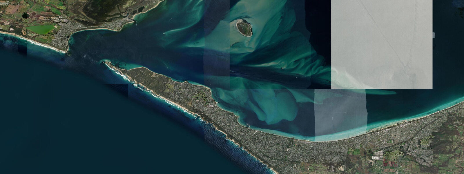
Sorrento sits on the Mornington Peninsula at Point Nepean, adjacent to the narrow entrance channel of Port Phillip Bay — one of the most hydraulically active stretches of water in Australia. That entrance, known as the Rip, is a 1.2-kilometre gap between Point Nepean and Point Lonsdale across which the entire tidal exchange of a 1,930-square-kilometre bay is forced twice a day. Spring tidal currents through the Rip reach 6 to 8 knots, among the strongest recorded in Australian coastal waters. The result is a water surface that can be violently rough in the Rip passage itself even on days when the bay inside and the open Bass Strait outside are both calm.
Mean tidal range inside Port Phillip at Sorrento is approximately 0.8 metres — relatively moderate — but the restricted entrance dramatically amplifies current speed. The physics are straightforward: a large volume of water forced through a narrow gap produces fast flow, and Port Phillip is a large bay through a very small hole. The Victorian tide gauge at Point Lonsdale is the primary reference for the Rip entrance; the Bureau of Meteorology (BoM) publishes authoritative predictions.
The Rip historically claimed many ships. The Eliza went down in 1839; over the following decades several dozen vessels were lost in the passage before the construction of lighthouses and the development of pilot boat services began reducing the toll. The region around Point Nepean is now a national park, and the walking tracks at the tip of the peninsula give views directly over the entrance from the clifftops.
The Sorrento to Queenscliff car and passenger ferry crosses the Rip daily, linking the Mornington Peninsula to the Bellarine Peninsula. The crossing is roughly 40 minutes and navigates the entrance channel; passengers see the Rip's current behaviour from deck at close range. The ferry operates on a timetable and is subject to cancellation in extreme conditions.
The Sorrento foreshore on the bay side has calm sheltered beach swimming — the water inside Port Phillip is protected from Bass Strait swell. The ocean side, on the Bass Strait coast of the peninsula, has exposed surf beaches. The contrast between the two sides of the peninsula, separated by 2 kilometres, is one of the more striking coastal geographies in southern Australia.
Predictions on this page come from Open-Meteo Marine, a global gridded ocean model accurate to within approximately ±45 minutes on timing and ±0.2–0.3 metres on height. For authoritative Australian tidal predictions, consult the Bureau of Meteorology at bom.gov.au.
Tide questions about Sorrento, VIC
Quick answers to the most common questions about tide times, range, and water access at Sorrento, VIC.
What is the tidal range at Sorrento?
Inside Port Phillip Bay at Sorrento, mean tidal range is approximately 0.8 metres — moderate. However, the 1.2-kilometre-wide Rip entrance between Point Nepean and Point Lonsdale concentrates the tidal exchange of the entire 1,930-square-kilometre bay, producing spring tidal currents of 6 to 8 knots through the channel. The Rip's behaviour is driven by the tidal cycle; the BoM Point Lonsdale tide gauge is the authoritative reference.
What is the Rip at Port Phillip Heads and why is it dangerous?
The Rip is the 1.2-kilometre entrance to Port Phillip Bay between Point Nepean and Point Lonsdale. All tidal water exchanged by the 1,930-square-kilometre bay flows through this gap twice daily, producing spring currents of 6 to 8 knots. In an opposing wind or sea, the current produces steep, confused waves. Historically the Rip claimed many ships; today it is managed by a pilot service and the entrance is marked, but small vessels should treat it with serious caution and time transits around slack water.
Can I take a ferry from Sorrento to Queenscliff?
Yes. The Sorrento to Queenscliff ferry links the Mornington Peninsula to the Bellarine Peninsula across the Port Phillip entrance. It carries both passengers and vehicles. The crossing takes approximately 40 minutes and travels through the Rip entrance channel — you see the current behaviour directly from the deck. The ferry operates on a timetable; check the operator's current schedule and book ahead in peak season. Services can be cancelled in severe conditions.
Where can I walk to see the Rip at Point Nepean?
Point Nepean National Park occupies the tip of the Mornington Peninsula. Walking and cycling tracks follow the old quarantine station road to the point, with clifftop lookouts directly above the entrance channel. The viewing platform near the point gives one of the best vantage points for watching the Rip current — most dramatic on spring tides when the flow is visible as a distinct current surface against the surrounding water. Distance from the Portsea visitor entry point to the tip is approximately 9 kilometres one way; return shuttles operate in peak season.
Are the tide predictions on this page suitable for navigation through the Rip?
No. Predictions here come from Open-Meteo Marine, a global ocean model providing indicative guidance only. The Rip is a Class 1 navigation hazard where current timing and peak speed are critical safety variables. For transit planning, use Bureau of Meteorology (BoM) authoritative tidal predictions at bom.gov.au, the official Port Phillip sea pilot service information, and current maritime forecasts. Never plan a Rip transit based on model predictions alone.
8-day tide table — Sorrento, VIC
Heights relative to MSL. Predictions: Open-Meteo Marine (MeteoFrance SMOC, 0.08° grid) — heights relative to MSL (not chart datum / LAT). Model-derived.
| Day | Type | Time | Height |
|---|---|---|---|
| Sun 21 Jun | Low | 10:00 | -1.0m |
| High | 16:02 | 1.1m | |
| Low | 21:57 | -0.9m | |
| Mon 22 Jun | High | 04:20 | 0.7m |
| Low | 10:00 | -0.9m | |
| High | 16:42 | 1.0m | |
| Low | 22:42 | -0.9m | |
| Tue 23 Jun | High | 05:16 | 0.8m |
| Low | 10:46 | -0.6m | |
| High | 17:21 | 0.9m | |
| Low | 23:27 | -0.9m | |
| Wed 24 Jun | High | 06:10 | 0.7m |
| Low | 11:36 | -0.5m | |
| High | 18:02 | 0.7m | |
| Thu 25 Jun | Low | 00:13 | -1.0m |
| High | 07:10 | 0.6m | |
| Low | 12:23 | -0.4m | |
| High | 18:46 | 0.5m | |
| Fri 26 Jun | Low | 00:58 | -0.9m |
| High | 08:10 | 0.5m | |
| Low | 13:15 | -0.3m | |
| High | 19:33 | 0.5m | |
| Sat 27 Jun | Low | 01:45 | -0.9m |
| High | 09:06 | 0.6m | |
| Low | 14:21 | -0.1m | |
| High | 20:25 | 0.5m | |
| Sun 28 Jun | Low | 02:27 | -0.7m |
| High | 09:00 | 0.8m |