Kakadu Coast tide times
Kakadu Coast tide forecast — heights relative to MSL.
Today's tide times for Kakadu Coast
Tide times at Kakadu Coast on Saturday, 27 June 2026: first high tide at 10:00, first low tide at 12:05, second high tide at 17:53. Sunrise 07:30, sunset 18:55.
Tide chart for Kakadu Coast
24-hour cosine-interpolated curve around the present moment. Heights relative to MSL. Predictions: Predictions: Open-Meteo Marine (MeteoFrance SMOC, 0.08° grid).
Sun, moon and conditions on Sat 27 Jun
Snapshot at build time — refreshes daily. Sea state from Open-Meteo Marine.
Highs and lows next 7 days
Every predicted high and low for the next week, with the daily tidal coefficient (0–120; higher = bigger swing, > 95 means stronger currents).
Other spots nearby
The three closest curated TideTurtle locations to Kakadu Coast, measured by great-circle distance.
Today's solunar windows
Solunar tradition: major periods are the ≈3h windows around moon transit and opposition; minor are ≈2h around moonrise and moonset. Pair with the local tide stage and wind for the best read.
Cycle dates near Kakadu Coast
Next spring tide on Wed 01 Jul (range 4.9m). Last neap on Sat 27 Jun. Next neap on Fri 03 Jul.
Spring tides cluster around new and full moons (biggest swings). Neap tides land on quarter moons (smallest swings). See the spring tide and neap tide glossary entries for the why.
About tides at Kakadu Coast
A short guide to the coastline at Kakadu Coast — geography, sea state, and what the tide is actually doing under your feet.
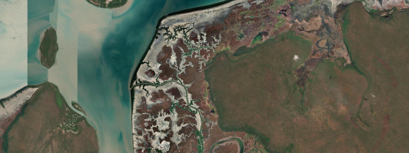
The coastal margin of Kakadu National Park fronts the Van Diemen Gulf on the western shore of the Northern Territory's Top End. This is not a well-known tourist coastline — there is no resort, no surf beach, and no boat ramp with a queue of trailers. What there is: an extraordinary tidal system where spring ranges reach approximately 5.5 m above Chart Datum, draining broad salt flats and mangrove estuaries that support one of the most diverse intertidal ecosystems in Australia.
The tides here are semidiurnal, and the landscape responds dramatically to the cycle. At high water, mangrove channels several metres deep carry water kilometres into the floodplain. At low water, the same channels become shallow mud runs between walls of pneumatophores — the finger-like mangrove roots that stand exposed in their thousands at low tide. The salt flats behind the mangroves are hypersaline, sun-baked, and almost completely flat, creating a visual contrast between the biological richness of the mangrove fringe and the apparent emptiness beyond it.
Kakadu's inland rock art is world-famous, but the Ubirr site at the edge of the Arnhem Land escarpment is directly tidal in the sense that the floodplain visible from the Ubirr lookout is inundated each wet season by a combination of monsoonal rain and tidal backwater from the South Alligator River estuary. The rock art at Ubirr depicts barramundi, sawfish, long-necked turtles, and other species that occupy the tidal zone — painted by people who read this landscape intimately over thousands of years.
Fishing on the Kakadu coast is done by boat, and the South Alligator River is the primary access point. The river name has nothing to do with alligators — the explorers who named it confused the large saltwater crocodiles for alligators. Barramundi and threadfin salmon are the target species. Threadfin salmon congregate near river mouths on the incoming tide, particularly in the early dry season (May–June) when run-off still colours the water and bait is abundant. Barramundi hold in the mangrove snags and drop-offs; they bite best at the tide change.
Migratory shorebirds use the Kakadu coast tidal flats as a key staging and refuelling area. From September through March, the exposed mud at low water hosts bar-tailed godwits, great knots, red-necked stints, and other species on their journeys between the Arctic and Australia. Bird surveys on the Van Diemen Gulf coast have recorded over 30 migratory species at peak times. Low tides at dawn in September and October are the priority window for birdwatchers.
All NT coastal and estuarine waters are saltwater crocodile habitat, and the Kakadu coast is home to a dense crocodile population — the national park's waterways have been closed to recreational swimming for decades, and that closure is absolute. Crocodile attacks in the park have been documented repeatedly. Access the coast and rivers here by boat and stay aboard or on clearly elevated banks. Do not wade in turbid water, do not clean fish at the water's edge, and do not approach the shoreline at night. Photography of the tidal system is best done from the Ubirr and Yellow Water cruise platforms, which are specifically designed for safe wildlife access.
The Yellow Water Wetlands (Ngurrungurrudjba) at the junction of Jim Jim Creek and the South Alligator River is a tidal and seasonal wetland accessible by guided boat cruise. Water levels here are influenced by both wet-season flooding and tidal movement up the South Alligator system. The cruise platform rises and falls with the water, and twice-daily departures are timed around morning and late-afternoon light.
Tidal predictions here use the Open-Meteo Marine gridded model (±45 minutes on timing, ±0.3 m on height). Not for navigation.
Tide questions about Kakadu Coast
Quick answers to the most common questions about tide times, range, and water access at Kakadu Coast.
What is the tidal range on the Kakadu coast?
Spring tidal range on the Van Diemen Gulf coast of Kakadu is approximately 5.5 m above Chart Datum. The range varies somewhat depending on position along the coast — the shallow, shelving nature of the gulf amplifies tidal energy, and the mangrove estuaries experience strong tidal currents on both flood and ebb. Neap tides reduce the range to roughly 2–3 m. The tidal cycle is semidiurnal with diurnal inequality, producing two unequal highs and two unequal lows each day. At peak ebb on a spring tide, tidal channels drain rapidly and small boats can ground within minutes on the exposed mud.
Can I swim in the water at Kakadu?
Swimming in the coastal and estuarine waters of Kakadu National Park is not permitted. All waterways, including the South Alligator River, the Van Diemen Gulf coastline, and all tidal creeks, are active saltwater crocodile habitat with a dense population. The park has a long-standing absolute swimming ban in these areas. Some inland freshwater pools within the park have managed swimming areas with crocodile monitoring — check current safety status at the park visitor centre before using any freshwater site, as crocodiles can move into these areas seasonally.
When do migratory shorebirds arrive on the Kakadu coast?
Migratory shorebirds begin arriving on the Kakadu tidal flats from late September, with numbers peaking through October and November on the southward migration from breeding grounds in Siberia, Alaska, and Arctic Canada. A second wave moves north again from February to April. Bar-tailed godwits, great knots, and red-necked stints are among the most numerous species. Low tides at dawn provide the best conditions — birds are actively feeding on exposed mud, and light is ideal for photography. The Van Diemen Gulf coastline and the South Alligator estuary mouth are the primary concentration points.
How do I fish the South Alligator River in Kakadu?
Boat access is the standard approach. The South Alligator River boat ramp off the Arnhem Highway is the main launch point. Barramundi hold in mangrove snags, rock bars, and channel drop-offs, with the tide change (an hour either side of high or low water) being the most productive window. Threadfin salmon concentrate near the river mouth on incoming tides in May and June. A Northern Territory recreational fishing licence is required. All fish must be handled and released or kept according to NT bag and size limits. Do not clean fish at the water's edge.
What does the Ubirr rock art tell us about the tidal environment?
The rock art at Ubirr, painted over thousands of years by Aboriginal artists, depicts barramundi, sawfish, long-necked turtles, file snakes, and other species that inhabit the tidal and seasonal wetland zone. The X-ray style art shows the internal anatomy of fish in precise detail, indicating deep ecological knowledge of the species that move through the tidal system. The floodplain visible from the Ubirr lookout is inundated annually by a combination of tidal backwater from the South Alligator estuary and wet-season rainfall — a tidal influence that has shaped this landscape and its human occupation for millennia.
7-day tide table — Kakadu Coast
Heights relative to MSL. Predictions: Open-Meteo Marine (MeteoFrance SMOC, 0.08° grid) — heights relative to MSL (not chart datum / LAT). Model-derived.
| Day | Type | Time | Height |
|---|---|---|---|
| Sat 27 Jun | High | 10:00 | 0.3m |
| Low | 12:05 | -0.4m | |
| High | 17:53 | 2.0m | |
| Sun 28 Jun | Low | 00:26 | -1.6m |
| High | 07:04 | 2.3m | |
| Low | 13:03 | -0.4m | |
| High | 18:46 | 2.0m | |
| Mon 29 Jun | Low | 01:12 | -1.8m |
| High | 07:49 | 2.5m | |
| Low | 13:51 | -0.6m | |
| High | 19:32 | 2.1m | |
| Tue 30 Jun | Low | 01:57 | -1.9m |
| High | 08:28 | 2.7m | |
| Low | 14:31 | -0.6m | |
| High | 20:11 | 2.3m | |
| Wed 01 Jul | Low | 02:37 | -2.0m |
| High | 09:07 | 2.8m | |
| Low | 15:12 | -0.8m | |
| High | 20:53 | 2.3m | |
| Thu 02 Jul | Low | 03:16 | -2.0m |
| High | 09:42 | 2.9m | |
| Low | 15:50 | -0.9m | |
| High | 21:31 | 2.4m | |
| Fri 03 Jul | Low | 03:52 | -2.0m |
| High | 10:14 | 2.9m | |
| Low | 16:24 | -1.0m | |
| High | 22:08 | 2.5m |