Béjaïa tide times
Béjaïa tide forecast — heights relative to MSL.
Today's tide times for Béjaïa
Tide times at Béjaïa on Saturday, 4 July 2026: first high tide at 01:00am. Sunrise 05:25am, sunset 08:02pm.
Tide chart for Béjaïa
24-hour cosine-interpolated curve around the present moment. Heights relative to MSL. Predictions: Predictions: Open-Meteo Marine (MeteoFrance SMOC, 0.08° grid).
Sun, moon and conditions on Sat 04 Jul
Snapshot at build time — refreshes daily. Sea state from Open-Meteo Marine.
Highs and lows next 7 days
Every predicted high and low for the next week, with the daily tidal coefficient (0–120; higher = bigger swing, > 95 means stronger currents).
Other spots nearby
The three closest curated TideTurtle locations to Béjaïa, measured by great-circle distance.
Today's solunar windows
Solunar tradition: major periods are the ≈3h windows around moon transit and opposition; minor are ≈2h around moonrise and moonset. Pair with the local tide stage and wind for the best read.
About tides at Béjaïa
A short guide to the coastline at Béjaïa — geography, sea state, and what the tide is actually doing under your feet.
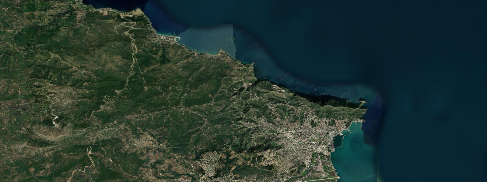
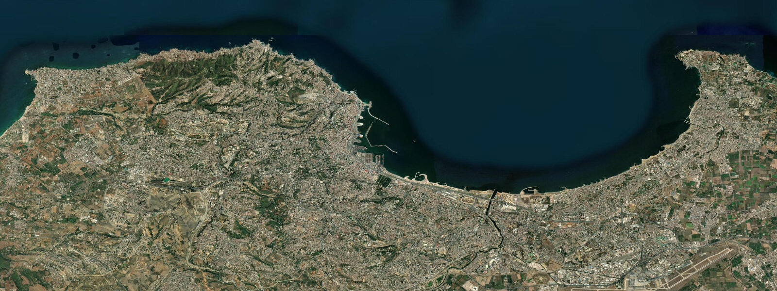
Béjaïa is a port city at the mouth of the Soummam River, on the coast of the Kabylie region of northern Algeria. The city sits where the river valley — one of the main agricultural corridors of Kabylie — opens to the Mediterranean between the Gouraya headland to the north and the Tazougart Cape to the east. The Gouraya massif rises sharply from the sea to 672 metres, creating one of the more dramatic coastal backdrops on the Algerian Mediterranean coast.
The harbour at Béjaïa is one of Algeria's significant commercial ports, handling hydrocarbons export (a pipeline from the Sahara terminates here), container traffic, and ferry services to Marseille and Genoa. The city is also the cultural capital of the Kabyle Berber heartland, and the combination of urban Kabylie culture, Mediterranean sea, and the Gouraya national park makes Béjaïa unusually layered for a North African coastal city.
Tide data for Béjaïa uses Open-Meteo Marine's global model. Timing accuracy ±45 minutes, height accuracy ±0.2 to 0.3 metres. The central Mediterranean at Béjaïa is nearly tideless: spring tidal range is 0.1 to 0.4 metres. As throughout the Algerian coast, wind setup and atmospheric pressure dominate actual water-level variability. The Soummam River mouth adds a seasonal freshwater influence: winter and spring rainfall in the Kabylie mountains pushes river discharge, temporarily raising estuary water levels above the tidal baseline.
The Gouraya National Park, directly north of the city, protects 2,080 hectares of coastal cliff and forest habitat. The park's coastline section includes the Corniche Kabyle — a cliff road that runs west from Béjaïa along the base of the Gouraya massif, with sea views from 200 to 400 metres above the water. The Bou Blal lighthouse, on the western headland, marks the approach to Béjaïa bay from the open Mediterranean.
For divers and snorkellers, the rocky limestone coast of the Gouraya provides some of the better underwater terrain on the central Algeria coast. The cliff-base habitat at 5 to 30 metres depth has grouper, sea bream, and the octopus and moray eel populations typical of the North African Mediterranean. The Soummam river plume can reduce visibility near the river mouth after rainfall; dive sites on the Gouraya headland to the northwest of the port avoid this problem.
The beaches east of Béjaïa port — particularly the long Tichi and Aokas strips — are the main family beach destinations, busy in July and August with Algerian domestic tourists. The Mediterranean here warms to 25 to 26°C at peak summer. The Corniche road provides a sequence of cliff-top viewpoints over the bay, usable as photography locations at sunrise or sunset.
The Gouraya massif provides one of the few sections of the Algerian Mediterranean coast where the mountain meets the sea directly, without an intervening coastal plain. The Corniche Kabyle — the cliff road along the Gouraya base — is one of Algeria's celebrated scenic drives, comparable to the coastal corniche roads of southern France and northern Morocco. The road passes through tunnels cut through limestone headlands and along ledges where the sea is visible hundreds of metres below. Several miradors (viewing platforms) are cut into the cliff face and provide photography positions over the Béjaïa bay.
The Soummam Valley behind Béjaïa is the main agricultural corridor of Kabylie, producing olives, figs, and grain. The river that drains it — the Soummam — carries seasonal loads of agricultural and urban runoff into the bay, particularly after winter rains. The river plume is the main variable affecting dive and snorkel visibility in the inner bay; sites on the Gouraya headland to the northwest of the port are consistently cleaner because they are upwind and upcurrent from the river input.
The Taskriout promontory, visible to the east of Béjaïa across the bay, is an archaeological site with Phoenician and Roman occupation layers. The pattern of Phoenician coastal settlement — every natural harbour on the North African coast, regardless of current development status — is reflected in the documented sites from Ghazaouet in the west to Annaba in the east. Béjaïa's position at the mouth of the Soummam Valley gave it exceptional importance as a trading post connecting the Mediterranean to the Kabylie interior.
Tide questions about Béjaïa
Quick answers to the most common questions about tide times, range, and water access at Béjaïa.
What is the tidal range at Béjaïa?
Béjaïa is on the central Algerian Mediterranean coast, where the astronomical tidal range is 0.1 to 0.4 metres — effectively microtidal. Wind setup and atmospheric pressure are the dominant drivers of actual water-level change; a 20 hPa pressure difference produces a 20-centimetre sea-level anomaly, comparable to the full tidal range. Tide data here uses Open-Meteo Marine's global model; at this scale, the ±0.2 to 0.3 metre height tolerance means the predictions are indicative. The Soummam River mouth has additional seasonal freshwater input in winter, temporarily modifying the bay water level and reducing salinity in the inner harbour.
Can I hike in the Gouraya National Park?
The Gouraya National Park has several marked hiking trails, most starting from the Béjaïa city edge or from car parks on the Corniche Kabyle road. The main summit trail to Gouraya peak (672 metres) takes 2 to 3 hours return from the lower trailheads. The Corniche road itself, accessible by car, provides viewpoints over the bay and sea without hiking. The park is home to Barbary macaques — macaques are visible near the summit and along the upper trails, particularly in the morning. The park is open year-round; the coolest hiking conditions are October through April. Summer heat above 35°C makes the exposed cliff section of the trail uncomfortable in the middle of the day.
Is there a ferry from Béjaïa to France or Italy?
Béjaïa operates seasonal ferry services to Marseille (France) and Genoa (Italy), typically from June through September for the peak Algerian diaspora summer travel period. Services may run year-round at reduced frequency. The ferry operator is typically the Algerian state ferry company ENTMV in partnership with European carriers. Crossing time to Marseille is approximately 20 to 22 hours; to Genoa around 22 to 24 hours. Booking in advance is essential for summer departures, which fill quickly. Check the current schedule and booking procedure with ENTMV or through Algerian travel agents before planning a crossing.
What is the diving like around Béjaïa?
The limestone cliff base and rocky reef habitat around the Gouraya headland provides some of the better diving terrain on the central Algerian coast. Typical sites are at 5 to 30 metres depth; species include grouper, various bream, saddled wrasse, octopus, and moray eels. Posidonia seagrass beds occupy the sandy patches at 5 to 15 metres. Visibility runs 10 to 20 metres in settled summer conditions; reduced after wind events or river discharge. Béjaïa has a small number of local dive clubs with equipment rental; contact clubs in the city or through the regional tourism office for current operators.
What is the cultural significance of Béjaïa?
Béjaïa is the historical and cultural centre of the Kabyle Berber heartland of northern Algeria. The Kabyle people are the largest Berber-speaking population in Algeria, and Béjaïa (historically known as Béjaïa under Berber rule, and Bougie under French colonialism) has been a centre of Amazigh cultural identity and language activism. The city was historically significant as a medieval trade centre — the mathematician Fibonacci visited Béjaïa in the 12th century and is credited with bringing Hindu-Arabic numerals to Europe from here. The old city walls, the Kasbah, and several Byzantine and medieval towers survive in the upper town.
7-day tide table — Béjaïa
Heights relative to MSL. Predictions: Open-Meteo Marine (MeteoFrance SMOC, 0.08° grid) — heights relative to MSL (not chart datum / LAT). Model-derived.
| Day | Type | Time | Height |
|---|---|---|---|
| Sat 04 Jul | High | 01:00 | -0.4m |
| Sun 05 Jul | Low | 07:00 | -0.5m |
| Mon 06 Jul | — | ||
| Tue 07 Jul | — | ||
| Wed 08 Jul | — | ||
| Thu 09 Jul | High | 02:00 | -0.3m |
| Low | 09:00 | -0.4m | |
| Fri 10 Jul | High | 18:00 | -0.2m |