Algiers tide times
Algiers tide forecast — heights relative to MSL.
Tide chart for Algiers
24-hour cosine-interpolated curve around the present moment. Heights relative to MSL. Predictions: Predictions: Open-Meteo Marine (MeteoFrance SMOC, 0.08° grid).
Sun, moon and conditions on Fri 03 Jul
Snapshot at build time — refreshes daily. Sea state from Open-Meteo Marine.
Highs and lows next 7 days
Every predicted high and low for the next week, with the daily tidal coefficient (0–120; higher = bigger swing, > 95 means stronger currents).
Other spots nearby
The three closest curated TideTurtle locations to Algiers, measured by great-circle distance.
Today's solunar windows
Solunar tradition: major periods are the ≈3h windows around moon transit and opposition; minor are ≈2h around moonrise and moonset. Pair with the local tide stage and wind for the best read.
About tides at Algiers
A short guide to the coastline at Algiers — geography, sea state, and what the tide is actually doing under your feet.
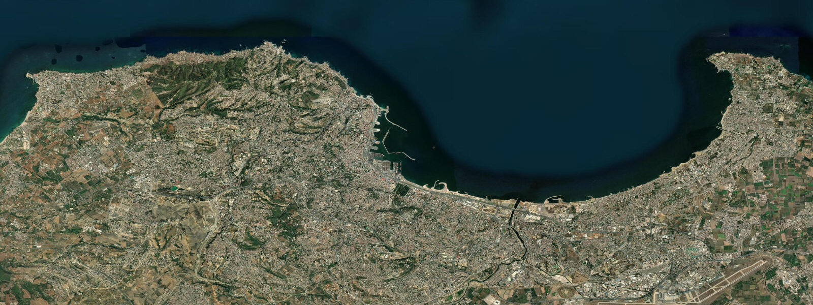
Algiers sits on a north-facing bay in the western Mediterranean, its white buildings climbing a hill from the harbour — the classic image of the city that the name Algiers (Al-Jazair, the Islands) captures from the original sandbar islets that were incorporated into the harbour works over centuries. The bay is curved and sheltered, with the Sahel hills rising steeply behind the city and the Mediterranean to the north.
The Mediterranean tidal regime at Algiers is microtidal. The Strait of Gibraltar attenuates the Atlantic tidal wave severely before it enters the Mediterranean basin; what remains at Algiers is a spring tidal range of approximately 0.15 to 0.25 metres — barely perceptible at the waterfront and irrelevant for most practical purposes. Water level variation here is dominated by atmospheric forcing: the Sirocco (Chehili), blowing hot and dusty from the Sahara, can push sea level up or down by 0.2 to 0.4 metres through the barometric inverse effect; northerly gales pile water against the coast in the opposite direction. The astronomical tide is background noise.
The Casbah of Algiers is a UNESCO World Heritage Site on the hillside above the old harbour. It is one of the finest surviving examples of an Ottoman-period urban medina — a dense, layered quarter of narrow lanes, vaulted passages, historic mosques, and Ottoman-era palaces (the Dar Aziza, the Dar Mustapha Pacha). The Casbah deteriorated significantly through the 20th century — much of the original housing stock is damaged or lost — but active restoration is under way. The upper Casbah, near the Citadel, retains significant architectural character. The harbour view from the upper Casbah gives the full panorama of the Bay of Algiers and the port below.
Port d'Alger is Algeria's busiest commercial port and the main ferry terminal for services to France (Marseille, Toulon) and Spain (Valencia, Alicante). The Algérie Ferries and SNCM-predecessor lines operate passenger and ro-pax services; crossing times to Marseille are approximately 24 hours. The port's scale is visible from the Corniche Algéroise — the coastal road running along the northern seafront east of the city, from which the container and passenger terminals are clearly seen.
The Martyrs' Monument (Maqam Echahid) dominates the Algiers skyline from its position on the hill above the city: three palm-leaf shaped concrete pylons rising 92 metres, completed in 1982 for the 20th anniversary of Algerian independence. It is visible from the bay and from most of the coastal road east of the city.
The main beach districts are east and west of the city centre. The beaches at Club des Pins (west, reserved access), Zeralda, and Moretti (east) attract summer crowds in July and August. The summer beach season at Algiers is intense — the Mediterranean reaches 25-27°C in August, the evenings are warm, and the beach infrastructure (clubs privés, food stalls, water sports) is fully deployed. The Corniche Algéroise is a summer evening promenade for the city's population.
For those watching the sea rather than swimming in it: the Bay of Algiers winter storms (November through February) produce short, steep Mediterranean wave trains driven by northerly gales. The harbour entrance breakwater and the Corniche Algéroise seawall provide viewing platforms for the wave action against the rocks; the microtidal regime means the water level is nearly constant and the storm surge effect is the main variable.
The Algiers fish market (marché des poissons) near the Casbah waterfront is one of the better morning destinations. The Mediterranean fish catch — sea bass (loup de mer), red mullet, bream, and various shellfish — is landed daily; the market is busiest from 07:00 to 09:00. The North African Mediterranean coast is a productive fishing zone and the species variety at an Algerian fish market reflects a different regime than the Atlantic coast markets further west. For those walking the Casbah in the morning, the fish market is a natural first stop on the downhill route from the upper quarter to the harbour.
Predictions on this page come from Open-Meteo Marine, a gridded global ocean model. Accuracy is typically within plus or minus 45 minutes on timing and 0.2 to 0.3 metres on height — model-derived, not from a local gauge. The authoritative source for tidal and marine data in Algeria is the Algerian National Institute of Meteorology (ONM) and the Algerian General Maritime Directorate.
Tide questions about Algiers
Quick answers to the most common questions about tide times, range, and water access at Algiers.
What is the tidal range at Algiers?
Algiers is in the Mediterranean, where tides are microtidal. The Strait of Gibraltar severely attenuates the Atlantic tidal wave entering the Mediterranean basin; the spring tidal range at Algiers is approximately 0.15 to 0.25 metres — barely visible at the waterfront. Water level variation is dominated by atmospheric pressure and wind rather than the astronomical tide. The Sirocco wind and winter northerly gales produce sea level changes of 0.2 to 0.4 metres that dwarf the tidal signal. For practical purposes — fishing, beach access, boating — the tide at Algiers is not a significant planning variable.
What is the Casbah of Algiers and is it safe to visit?
The Casbah is a UNESCO World Heritage Site — an Ottoman-period urban medina on the hillside above the old harbour. It is one of the best surviving examples of a historic North African medina, with narrow lanes, vaulted passages, 16th-17th century mosques, and Ottoman palaces. It has deteriorated through the 20th century and restoration is ongoing. The Casbah receives visitors and guided tours are available; independent navigation in the denser upper sections is possible but a guide helps with orientation and access to interiors. The upper Casbah near the Citadel retains the most architectural character. The city and tourist authorities are increasingly active in promoting safe access.
What ferry routes operate from Algiers to Europe?
Algiers is the main Algerian ferry port for services to France and Spain. Algérie Ferries and other operators run passenger and ro-pax vehicle-and-passenger services to Marseille (approximately 24 hours), Toulon (approximately 24 hours), and Valencia, Spain (approximately 24 hours). Services are most frequent in summer (June-September), when the Algerian diaspora in France makes the crossing for summer holidays. The port is visible from the Corniche Algéroise coastal road. Booking in advance is essential for summer crossings; capacity can be limited in peak July-August period.
When is the best time to visit Algiers beaches?
The Mediterranean beach season at Algiers runs June through September. The sea reaches 25-27°C in August; the evenings are warm and the beach clubs (clubs privés) at Zeralda and Moretti east of the city are fully operational. July and August are the busiest months, with the Algerian diaspora from France returning for summer. May and October are transitional — warm enough for the sea but quieter. The Corniche Algéroise is a year-round evening promenade destination. Winter (November-February) brings northerly gales and short, steep Mediterranean wave trains — interesting for coastal weather observation but not for swimming.
What is the Martyrs' Monument in Algiers?
The Martyrs' Monument (Maqam Echahid) is a 92-metre concrete structure on a hill above Algiers, built in 1982 for the 20th anniversary of Algerian independence from France. Its three palm-leaf shaped pylons are visible from the bay and from the Corniche coastal road east of the city. It commemorates the 1.5 million Algerians killed during the War of Independence (1954-1962). The monument contains a small museum and an eternal flame beneath the central arch. The hilltop position gives views over the entire Bay of Algiers and the city below. Entry is free; access by road from the city centre.
4-day tide table — Algiers
Heights relative to MSL. Predictions: Open-Meteo Marine (MeteoFrance SMOC, 0.08° grid) — heights relative to MSL (not chart datum / LAT). Model-derived.
| Day | Type | Time | Height |
|---|---|---|---|
| Fri 03 Jul | — | ||
| Sat 04 Jul | — | ||
| Sun 05 Jul | — | ||
| Mon 06 Jul | High | 00:00 | -0.4m |